ADVERTISEMENT

'Carina'-enhanced 'habagat' to dampen SONA — PAGASA

Published Jul 21, 2024 01:17 am

At A Glance

  • PAGASA said the southwest monsoon, or "habagat," may bring occasional moderate to intense rains and thunderstorms over the western portions of Luzon from Monday to Tuesday, July 23.
  • The possibility of hoisting Wind Signal No. 1 over extreme Northern Luzon and the northeastern portion of mainland Cagayan by Sunday evening or Monday is not ruled out, in anticipation of strong winds associated with tropical storm Carina.
  • Carina is expected to exit the country's area of responsibility by Wednesday, July 24.
IMG_3998.jpeg
(Photo from Pixabay)

Parts of Luzon, including Metro Manila where President Marcos’ third State of the Nation Address (SONA) will be held, may experience rain showers on Monday, July 22, due to the southwest monsoon enhanced by tropical storm “Carina” (international name: “Gaemi”).

The Philippine Atmospheric, Geophysical and Astronomical Services Administration (PAGASA) said on Sunday, July 21 that the southwest monsoon, or “habagat,” may bring occasional moderate to intense rains and thunderstorms over the western portions of Luzon from Monday to Tuesday, July 23.

Scattered rain showers and thunderstorms may affect Antique, Occidental Mindoro, Zambales, Bataan, Pangasinan, La Union, and the northern Palawan, including Cuyo, Calamian, and Kalayaan Islands.

Isolated rain showers or thunderstorms may also occur in Metro Manila, Oriental Mindoro, Marinduque, Romblon, the rest of Palawan, Cavite, Laguna, Batangas, the rest of Visayas, and Mindanao.

IMG_3997.jpeg
Satellite image of Tropical Storm Carina (international name “Gaemi”) (PAGASA/Facebook)

Signal No. 1 possible

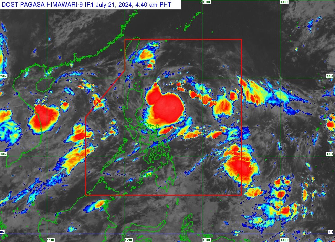
As of 4 a.m., PAGASA said Carina was located 490 kilometers east of Casiguran, Aurora, and has slightly intensified with maximum sustained winds of 75 kilometers per hour (kph) near the center and gusts of up to 90 kph.

It is currently moving west-northwestward at 10 kph and is less likely to make landfall.

However, its outer circulation may still affect some areas in eastern Luzon.

PAGASA said the possibility of hoisting Wind Signal No. 1 over extreme Northern Luzon and the northeastern portion of mainland Cagayan by Sunday evening or Monday is not ruled out, in anticipation of strong winds associated with the storm.

It added that moderate to heavy rains (50 to 100 millimeters) may affect the northeastern portion of mainland Cagayan and the eastern portion of Babuyan Islands by Monday.

On Tuesday, heavy to intense rains (100 to 200 millimeters) are expected in Batanes and moderate to heavy rains in Babuyan Islands.

Further intensification

PAGASA said Carina may steadily intensify over the next four days due to favorable environmental conditions.

It may become a severe tropical storm by Monday and a typhoon by Tuesday.

“Rapid intensification within the forecast period is possible,” PAGASA said.

Carina is projected to move generally northwestward over the Philippine Sea between Sunday and Monday, then shift northward by Tuesday.

Based on the track forecast, Carina is expected to remain far from the Philippine landmass and exit the country’s area of responsibility by Wednesday, July 24.

Related Tags

PAGASA Habagat SONA 2024 Tropical Storm Carina
ADVERTISEMENT
.most-popular .layout-ratio{ padding-bottom: 79.13%; } @media (min-width: 768px) and (max-width: 1024px) { .widget-title { font-size: 15px !important; } }

{{ articles_filter_1561_widget.title }}

.most-popular .layout-ratio{ padding-bottom: 79.13%; } @media (min-width: 768px) and (max-width: 1024px) { .widget-title { font-size: 15px !important; } }

{{ articles_filter_1562_widget.title }}

.most-popular .layout-ratio{ padding-bottom: 79.13%; } @media (min-width: 768px) and (max-width: 1024px) { .widget-title { font-size: 15px !important; } }

{{ articles_filter_1563_widget.title }}

{{ articles_filter_1564_widget.title }}

.mb-article-details { position: relative; } .mb-article-details .article-body-preview, .mb-article-details .article-body-summary{ font-size: 17px; line-height: 30px; font-family: "Libre Caslon Text", serif; color: #000; } .mb-article-details .article-body-preview iframe , .mb-article-details .article-body-summary iframe{ width: 100%; margin: auto; } .read-more-background { background: linear-gradient(180deg, color(display-p3 1.000 1.000 1.000 / 0) 13.75%, color(display-p3 1.000 1.000 1.000 / 0.8) 30.79%, color(display-p3 1.000 1.000 1.000) 72.5%); position: absolute; height: 200px; width: 100%; bottom: 0; display: flex; justify-content: center; align-items: center; padding: 0; } .read-more-background a{ color: #000; } .read-more-btn { padding: 17px 45px; font-family: Inter; font-weight: 700; font-size: 18px; line-height: 16px; text-align: center; vertical-align: middle; border: 1px solid black; background-color: white; } .hidden { display: none; }
function initializeAllSwipers() { // Get all hidden inputs with cms_article_id document.querySelectorAll('[id^="cms_article_id_"]').forEach(function (input) { const cmsArticleId = input.value; const articleSelector = '#article-' + cmsArticleId + ' .body_images'; const swiperElement = document.querySelector(articleSelector); if (swiperElement && !swiperElement.classList.contains('swiper-initialized')) { new Swiper(articleSelector, { loop: true, pagination: false, navigation: { nextEl: '#article-' + cmsArticleId + ' .swiper-button-next', prevEl: '#article-' + cmsArticleId + ' .swiper-button-prev', }, }); } }); } setTimeout(initializeAllSwipers, 3000); const intersectionObserver = new IntersectionObserver( (entries) => { entries.forEach((entry) => { if (entry.isIntersecting) { const newUrl = entry.target.getAttribute("data-url"); if (newUrl) { history.pushState(null, null, newUrl); let article = entry.target; // Extract metadata const author = article.querySelector('.author-section').textContent.replace('By', '').trim(); const section = article.querySelector('.section-info ').textContent.replace(' ', ' '); const title = article.querySelector('.article-title h1').textContent; // Parse URL for Chartbeat path format const parsedUrl = new URL(newUrl, window.location.origin); const cleanUrl = parsedUrl.host + parsedUrl.pathname; // Update Chartbeat configuration if (typeof window._sf_async_config !== 'undefined') { window._sf_async_config.path = cleanUrl; window._sf_async_config.sections = section; window._sf_async_config.authors = author; } // Track virtual page view with Chartbeat if (typeof pSUPERFLY !== 'undefined' && typeof pSUPERFLY.virtualPage === 'function') { try { pSUPERFLY.virtualPage({ path: cleanUrl, title: title, sections: section, authors: author }); } catch (error) { console.error('ping error', error); } } // Optional: Update document title if (title && title !== document.title) { document.title = title; } } } }); }, { threshold: 0.1 } ); function showArticleBody(button) { const article = button.closest("article"); const summary = article.querySelector(".article-body-summary"); const body = article.querySelector(".article-body-preview"); const readMoreSection = article.querySelector(".read-more-background"); // Hide summary and read-more section summary.style.display = "none"; readMoreSection.style.display = "none"; // Show the full article body body.classList.remove("hidden"); } document.addEventListener("DOMContentLoaded", () => { let loadCount = 0; // Track how many times articles are loaded const offset = [1, 2, 3, 4, 5, 6, 7, 8, 9, 10]; // Offset values const currentUrl = window.location.pathname.substring(1); let isLoading = false; // Prevent multiple calls if (!currentUrl) { console.log("Current URL is invalid."); return; } const sentinel = document.getElementById("load-more-sentinel"); if (!sentinel) { console.log("Sentinel element not found."); return; } function isSentinelVisible() { const rect = sentinel.getBoundingClientRect(); return ( rect.top < window.innerHeight && rect.bottom >= 0 ); } function onScroll() { if (isLoading) return; if (isSentinelVisible()) { if (loadCount >= offset.length) { console.log("Maximum load attempts reached."); window.removeEventListener("scroll", onScroll); return; } isLoading = true; const currentOffset = offset[loadCount]; window.loadMoreItems().then(() => { let article = document.querySelector('#widget_1690 > div:nth-last-of-type(2) article'); intersectionObserver.observe(article) loadCount++; }).catch(error => { console.error("Error loading more items:", error); }).finally(() => { isLoading = false; }); } } window.addEventListener("scroll", onScroll); });

Sign up by email to receive news.