


 Philippines
National
PAGASA: 'Aghon' to exit Philippine area of responsibility by May 29
Philippines
National
PAGASA: 'Aghon' to exit Philippine area of responsibility by May 29
PAGASA: 'Aghon' to exit Philippine area of responsibility by May 29


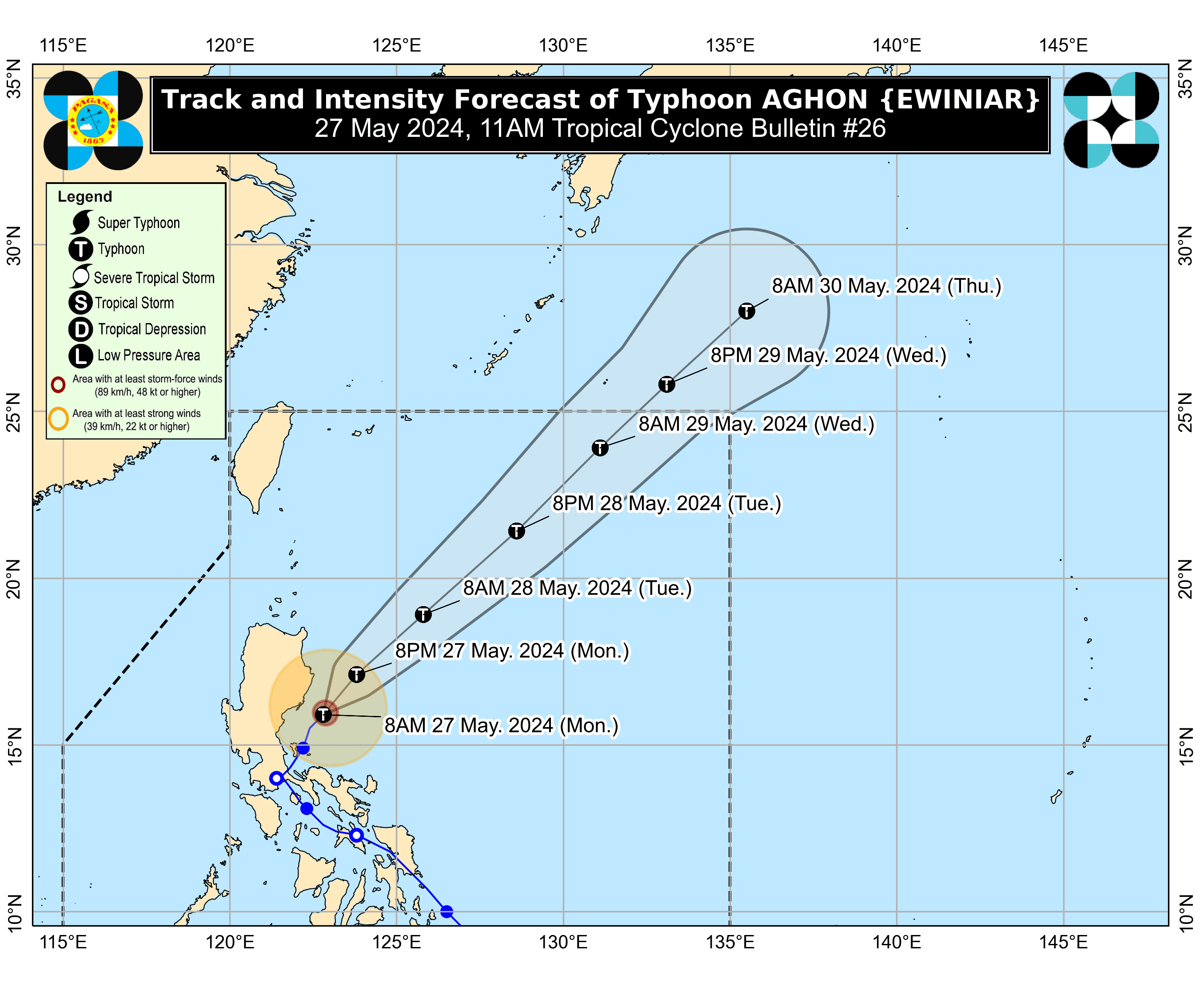
Typhoon “Aghon” (international name: Ewiniar) is expected to leave the Philippine area of responsibility (PAR) between Wednesday afternoon and evening, May 29.
In the tropical cyclone bulletin released at 11 a.m. on Monday, May 27, PAGASA said the typhoon will continue to move northeastward across the Philippine Sea before exiting the PAR.
Aghon made landfall in the Philippines nine times—in Homonhon Island and Giporlos in Eastern Samar at 11:20 p.m. on May 24 and 12:40 a.m. on May 25, respectively; Basiao and Cagduyong Island in Catbalogan, Samar at 4 a.m. and 5 a.m. on May 25, respectively; Batuan and Masbate City in Masbate province at 10:20 a.m. and 10:45 a.m. on May 25, respectively; Torrijos, Marinduque at 10 p.m. on May 25; Lucena City, Quezon at 4:30 a.m. on May 26; and Patnanungan, Quezon at 7 p.m. on May 26.
As of 10 a.m., Monday, the center of Aghon was located 100 kilometers southeast of Casiguran, Aurora.
It has maintained its maximum sustained winds of 140 kilometers per hour (kph) near the center, and gusts of up to 170 kph, while moving at a speed of 10 kph.
Wind warnings
PAGASA said tropical cyclone wind warnings remain in effect in some areas as Aghon continues to affect Luzon.
Signal No. 2 remains hoisted over the southeastern portion of Isabela and the northern portion of Aurora.
Meanwhile, Signal No. 1 is still in effect over the northeastern and southern portions of Isabela, the eastern portion of Quirino, the southern portion of Nueva Vizcaya, the rest of Aurora, the northern portion of Quezon including Polillo Islands, and the northwestern portion of Camarines Norte including Calaguas Islands.
Southwesterly wind flow
While typhoon Aghon moves away from the country, PAGASA said it may enhance the southwesterly wind flow, leading to moderate to heavy rains over Visayas and parts of MIMAROPA (Oriental Mindoro, Occidental Mindoro, Marinduque, Romblon, Palawan) in the next two days.
“Under these conditions, flooding and rain-induced landslides are likely, especially in areas that are highly or very highly susceptible to these hazards as identified in hazard maps and areas with significant antecedent rainfall,” PAGASA warned.
The prevalence of the southwesterly wind flow indicates the imminent arrival of the rainy season in the country.