


 Philippines
National
PAGASA: 'Aghon' slightly intensifies, lingers over Quezon province
Philippines
National
PAGASA: 'Aghon' slightly intensifies, lingers over Quezon province
PAGASA: 'Aghon' slightly intensifies, lingers over Quezon province


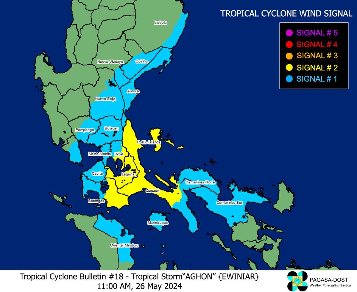
Tropical Cyclone Wind Signal No. 2 remains in effect over four areas in Southern Luzon, as tropical storm Aghon “meanders” over Quezon province.
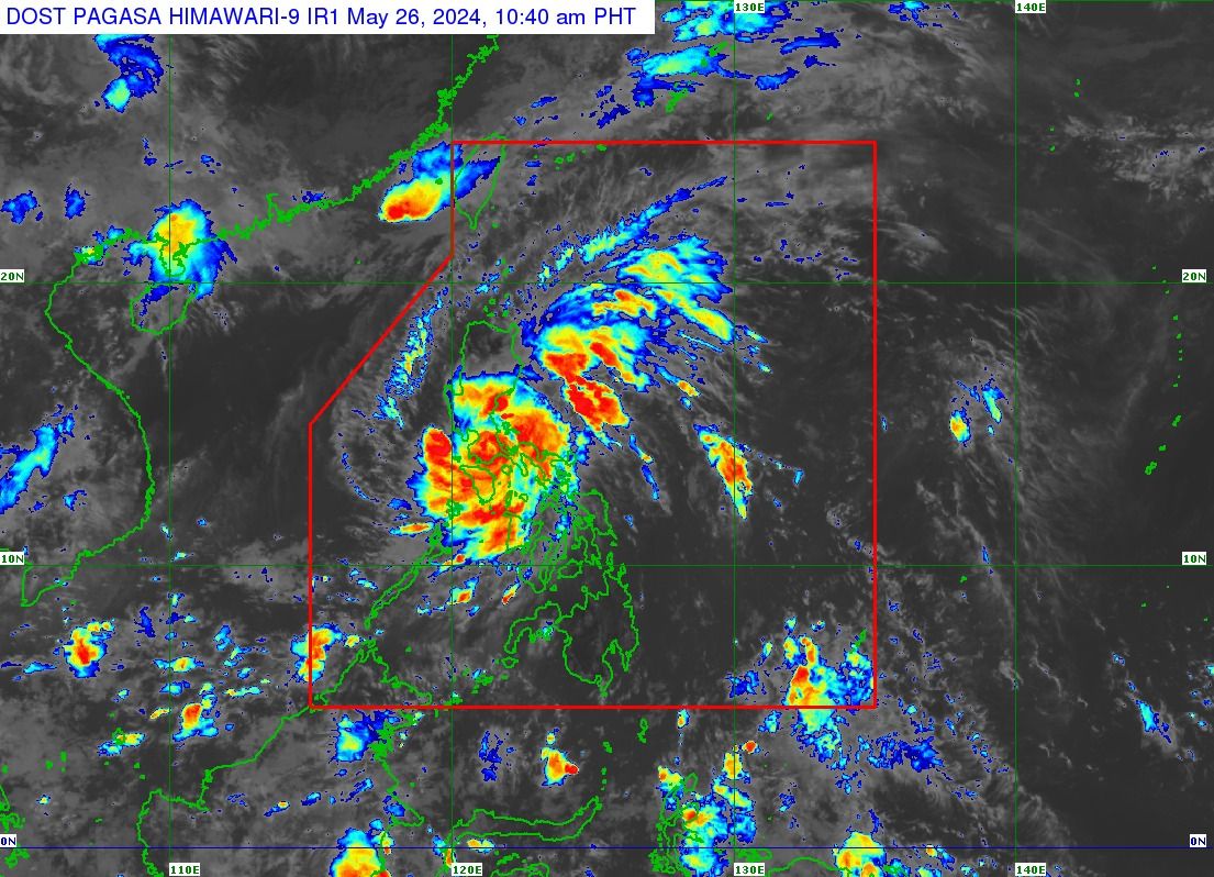
In the tropical cyclone bulletin released at 11 a.m., the Philippine Atmospheric, Geophysical and Astronomical Services Administration (PAGASA) located the center of tropical storm Aghon “in the vicinity of Sariaya, Quezon,” moving at a northwestward direction at a speed of 10 kph.
From 65 kilometers per hour (kph) maximum sustained winds and 90 kph of gusts, Aghon now has maximum sustained winds of 75 kph and gusts of up to 125 kph.
Severe winds, heavy rains
Due to Aghon’s severe winds, Signal No. 2 remains hoisted over the northern and central portions of Quezon, including Polillo Islands, Laguna, the eastern portion of Batangas, and the eastern portion of Rizal.
Meanwhile, Signal No. 1 is still in effect in the southeastern portion of Isabela, the southern portion of Quirino, the southern portion of Nueva Vizcaya, the eastern and southern portions of Nueva Ecija, the southern portion of Bataan, Aurora, the eastern portion of Pampanga, Bulacan, Metro Manila, the rest of Quezon, the rest of Rizal, Cavite, the rest of Batangas, the northern and central portions of Oriental Mindoro, Marinduque, the extreme northern portion of Romblon, Camarines Norte, and Camarines Sur
PAGASA said Quezon province may continue to experience intense rains, while Metro Manila, Aurora, the eastern portion of Bulacan, Rizal, Laguna, and Camarines Norte may have moderate to heavy rains with occasional intense rainfall until Monday noon, May 27.
Light to moderate rains with occasional heavy rains may also affect the eastern portion of Isabela, Nueva Ecija, the rest of Bulacan, the eastern portion of Pampanga, Cavite, Batangas, Oriental Mindoro, Occidental Mindoro, Romblon, Burias Island, the western portion of Camarines Sur, Cuyo Islands, Aklan, and Antique.
From Monday noon to Tuesday noon, May 28, light to moderate rains with occasional heavy rains may persist in the eastern portion of Isabela, the northern portion of Aurora, and the Polillo Islands.
PAGASA Weather Specialist Benison Estareja warned of flooding and rain-induced landslides, especially in areas that are “highly or very highly susceptible to these hazards” and in areas that experienced considerable rainfall for the past several days.
Gale, storm surge warnings
Estareja also said PAGASA has issued gale and storm surge warnings due to Aghon.
A gale warning has been issued due to “rough to very rough seas” along the coasts of Aurora, Marinduque, Quezon, including Polillo Island, southern Batangas, and northern Camarines Norte.
Moderate to rough seas may also affect the northern and eastern seaboards of Luzon, as well as the remaining seaboards of Bicol.
Likewise, Estareja said a storm surge warning was issued, advising residents along the coast to take extra precautions due to a “minimal to moderate risk of storm surge” expected in the next 24 hours.
Affected areas include eastern Cagayan, Isabela, Aurora, Camarines Norte, Camarines Sur, Albay, northern Masbate, Quezon, Romblon, Oriental Mindoro, Occidental Mindoro, Batangas, Cavite, Bulacan, Batangas, southern Zambales, and Metro Manila.
Estareja said Aghon made landfall eight times—in Homonhon Island and Giporlos in Eastern Samar (11:20 p.m., May 24 and 12:40 a.m., May 25, respectively); Basiao and Cagduyong Island in Catbalogan, Samar (4 a.m. and 5 a.m., May 25, respectively); Batuan and Masbate City in Masbate province (10:20 a.m. and 10:45 a.m., May 25, respectively; Torrijos, Marinduque (10 p.m., May 25); and Lucena City, Quezon (4:30 a.m., May 26).
He said Aghon may exit the Philippine area of responsibility by Wednesday, May 29.