


 Philippines
National
Signal No. 1 still up in 22 areas as 'Aghon' lingers over Luzon
Philippines
National
Signal No. 1 still up in 22 areas as 'Aghon' lingers over Luzon
Signal No. 1 still up in 22 areas as 'Aghon' lingers over Luzon


At A Glance
- Based on its track forecast, PAGASA anticipates Aghon to move northwestward or north-northwestward and make another landfall in mainland Quezon within the next 12 hours.
- Flooding and rain-induced landslides are likely, especially in areas that are highly or very highly susceptible to these hazards and in localities that have received significant amounts of rainfall for the past several days.
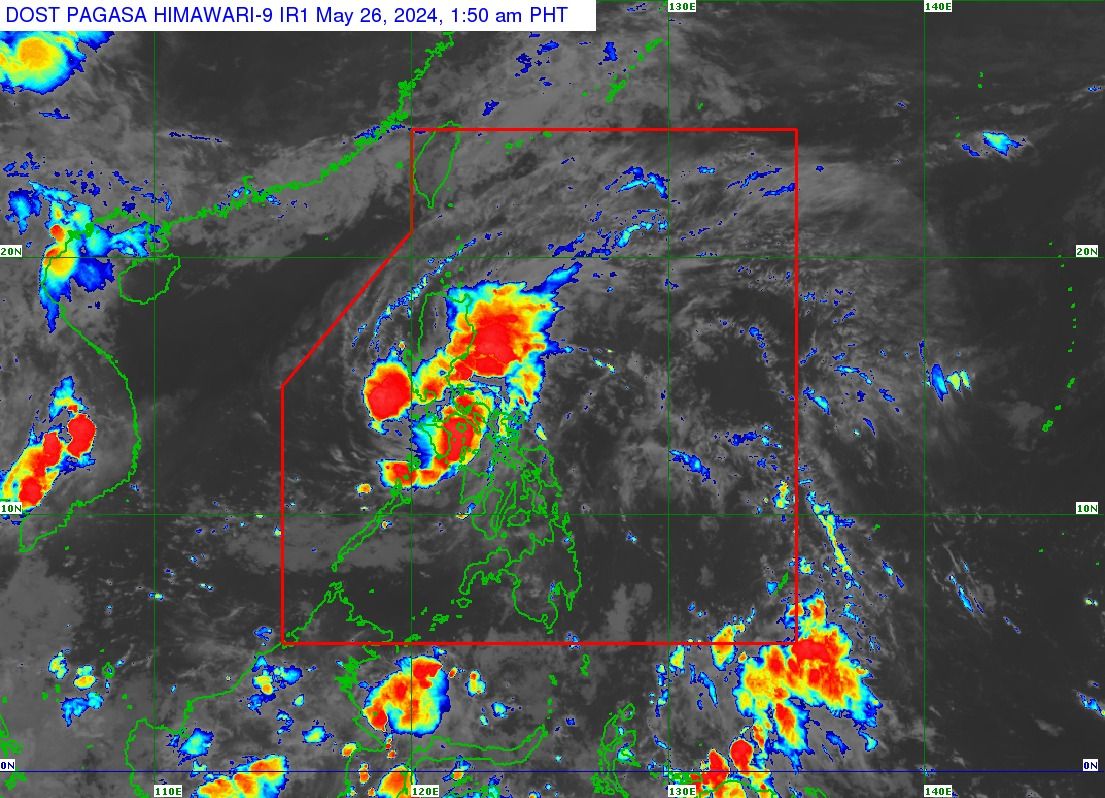
Tropical Cyclone Wind Signal No. 1 is still in effect over 22 areas, as tropical depression “Aghon” is expected to continue to move across Luzon on Sunday, May 26, said the Philippine Atmospheric, Geophysical and Astronomical Services Administration (PAGASA).
In the tropical cyclone bulletin issued at 2 a.m., Signal No. 1 remains hoisted over the southeastern portion of Isabela, the southern portion of Quirino, the southern portion of Nueva Vizcaya, the eastern and southern portions of Nueva Ecija, Aurora, the eastern portion of Pampanga, Bulacan, Metro Manila, Quezon, Rizal, Laguna, the eastern portion of Cavite, the eastern portion of Batangas, the northern portion of Oriental Mindoro, portions of Occidental Mindoro, Marinduque, Romblon, Camarines Norte, Camarines Sur, Catanduanes, Albay, and Burias Island.
“Minimal to minor impacts from strong winds are possible within any of the areas under Wind Signal No. 1,” PAGASA said.
It is still possible that the highest wind signal generated during Aghon's passage is Signal No. 2, it added.
Potential 8th landfall
As of 1 a.m., the center of Aghon was located “in the vicinity of Santa Cruz, Marinduque,” moving in a north-northwestward direction at a speed of 10 kilometers per hour (kph), while maintaining maximum sustained winds of 55 kph near the center and gusts of up to 90 kph.
Based on its track forecast, PAGASA anticipates Aghon to move northwestward or north-northwestward and make another landfall in mainland Quezon within the next 12 hours.
The tropical cyclone has already made landfall seven times—in Homonhon Island and Giporlos in Eastern Samar; Basiao and Cagduyong Island in Catbalogan, Samar; Batuan and Masbate City in Masbate province; and Torrijos, Marinduque.
Following its potential 8th landfall in Quezon province, Aghon is expected to start to veer north-northeastward and emerge over the waters east of Aurora by Sunday afternoon or evening.
Its track will shift northeastward for the remainder of the forecast period while gradually accelerating.
It is also projected to persist as a tropical depression while traversing Luzon in the next 12 hours, with an increasing chance of intensifying into a tropical storm within the same period.
Moreover, there is a likelihood of further intensification throughout the remaining forecast period, with the potential to peak at severe tropical storm or typhoon strength while within the PAR.
Rainy weather
PAGASA warned that Quezon province may continue to experience intense rainfall, while moderate to heavy rains with occasional intense downpours may persist over the southern portion of Aurora, the eastern portion of Bulacan, Rizal, Laguna, Marinduque, and Camarines Norte until Sunday evening.
Meanwhile, the rest of Aurora, Nueva Ecija, the rest of Bulacan, the eastern portion of Pampanga, Metro Manila, Cavite, Laguna, Batangas, Rizal, Oriental Mindoro, Occidental Mindoro, Romblon, Burias Island, and Camarines Sur may receive light to moderate rains with occasional heavy rainfall.
From Sunday evening to Monday evening, May 27, moderate to heavy rainfall with occasional intense rains may affect the eastern portion of Isabela, Aurora, the northern portion of Quezon including Polillo Islands, the eastern portions of Bulacan and Rizal, and Camarines Norte.
PAGASA said forecast rainfall is generally higher in elevated or mountainous areas.
Under these conditions, flooding and rain-induced landslides are likely, especially in areas that are highly or very highly susceptible to these hazards, as identified in hazard maps, and in localities that have received significant amounts of rainfall for the past several days.
PAGASA said Aghon may exit the Philippine area of responsibility by Wednesday, May 29.