ADVERTISEMENT

'Aghon' intensifies into storm; Signal No. 2 raised over parts of Quezon

Published May 25, 2024 11:11 pm
IMG_3809.jpeg
Satellite image of Tropical Storm Aghon (PAGASA)

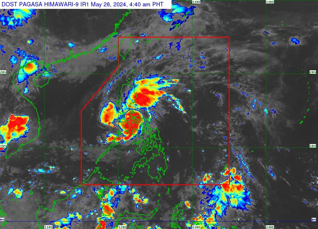
Some areas of Quezon province were placed under Tropical Cyclone Wind Signal No. 2 as Tropical Storm “Aghon” intensified on Sunday morning, May 26.

From a tropical depression, Aghon is now a storm, packing maximum sustained winds of 65 kilometers per hour (kph) near the center and gusts of up to 90 kph, based on the 5 a.m. tropical cyclone bulletin of the Philippine Atmospheric, Geophysical and Astronomical Services Administration (PAGASA).

Severe winds

Signal No. 2 was hoisted over the northern and central portions of Quezon including the Polillo Islands.

Signal No. 1 remains in effect in Metro Manila, the southeastern portion of Isabela, the southern portion of Quirino, the southern portion of Nueva Vizcaya, the eastern and southern portions of Nueva Ecija, Aurora, the eastern portion of Pampanga, Bulacan, the rest of Quezon, Rizal, Laguna, Cavite, Batangas, the northern portion of Oriental Mindoro, Marinduque, Romblon, Camarines Norte, Camarines Sur, the northern portion of Albay, and Burias Island.

“Minor to moderate impacts from strong winds are possible within any of the localities where Wind Signal No. 2 is hoisted [while] minimal to minor impacts from strong winds are possible within any of the areas under Wind Signal No. 1,” PAGASA said.

Potential 8th landfall

The center of Aghon was over the coastal waters of Lucena City, Quezon as of 4 a.m., moving in a northwestward direction at a speed of 10 kilometers per hour (kph). 

Based on its track forecast, PAGASA anticipates Aghon to make landfall in Quezon province within the next three hours.

Weather Specialist Daniel James Villamil said the tropical cyclone has already made landfall seven times—in Homonhon Island and Giporlos in Eastern Samar (11:20 p.m., May 24 and 12:40 a.m., May 25, respectively); Basiao and Cagduyong Island in Catbalogan, Samar (4 a.m. and 5 a.m., May 25, respectively); Batuan and Masbate City in Masbate province (10:20 a.m. and 10:45 a.m., May 25, respectively); and Torrijos, Marinduque (10 p.m., May 25).

Following its potential 8th landfall in Quezon province, Aghon is expected to move across the landmass of mainland Calabarzon (Cavite, Laguna, Batangas, Rizal, Quezon) and Polillo Islands.

The tropical storm will be over the waters off the east coast of Quezon or Aurora by Sunday evening or Monday early morning, May 27.

It is also projected to persist as a tropical storm although it may gradually weaken into a tropical depression while traversing mainland Calabarzon due to land interaction.

Moreover, there is a likelihood of further intensification throughout the remaining forecast period, with the potential to peak at severe tropical storm or typhoon strength while within the Philippine area of responsibility (PAR).

Heavy rainfall

PAGASA warned that Quezon province may continue to experience intense rainfall, while moderate to heavy rains with occasional intense downpours may persist over the eastern portion of Bulacan, Rizal, Laguna, Metro Manila, and Camarines Norte until Sunday evening.

Meanwhile, Nueva Ecija, the rest of Bulacan, the eastern portion of Pampanga, the rest of Quezon, Cavite, Laguna, Batangas, Rizal, Quezon, Oriental Mindoro, Occidental Mindoro, Romblon, Burias Island, and the western portion of Camarines Sur may receive light to moderate rains with occasional heavy rains.

From Sunday evening to Monday evening, moderate to heavy rainfall with occasional intense rains may affect the eastern portion of Isabela, the northern portion of Aurora, and the Polillo Islands.

PAGASA said forecast rainfall is generally higher in elevated or mountainous areas. 

Under these conditions, flooding and rain-induced landslides are likely, especially in areas that are highly or very highly susceptible to these hazards, as identified in hazard maps, and in localities that have received significant amounts of rainfall for the past several days. 

PAGASA said Aghon may exit the PAR by Wednesday, May 29.

Related Tags

Signal No. 1 signal no. 2 PAGASA landfall Tropical Storm Aghon
ADVERTISEMENT
.most-popular .layout-ratio{ padding-bottom: 79.13%; } @media (min-width: 768px) and (max-width: 1024px) { .widget-title { font-size: 15px !important; } }

{{ articles_filter_1561_widget.title }}

.most-popular .layout-ratio{ padding-bottom: 79.13%; } @media (min-width: 768px) and (max-width: 1024px) { .widget-title { font-size: 15px !important; } }

{{ articles_filter_1562_widget.title }}

.most-popular .layout-ratio{ padding-bottom: 79.13%; } @media (min-width: 768px) and (max-width: 1024px) { .widget-title { font-size: 15px !important; } }

{{ articles_filter_1563_widget.title }}

{{ articles_filter_1564_widget.title }}

.mb-article-details { position: relative; } .mb-article-details .article-body-preview, .mb-article-details .article-body-summary{ font-size: 17px; line-height: 30px; font-family: "Libre Caslon Text", serif; color: #000; } .mb-article-details .article-body-preview iframe , .mb-article-details .article-body-summary iframe{ width: 100%; margin: auto; } .read-more-background { background: linear-gradient(180deg, color(display-p3 1.000 1.000 1.000 / 0) 13.75%, color(display-p3 1.000 1.000 1.000 / 0.8) 30.79%, color(display-p3 1.000 1.000 1.000) 72.5%); position: absolute; height: 200px; width: 100%; bottom: 0; display: flex; justify-content: center; align-items: center; padding: 0; } .read-more-background a{ color: #000; } .read-more-btn { padding: 17px 45px; font-family: Inter; font-weight: 700; font-size: 18px; line-height: 16px; text-align: center; vertical-align: middle; border: 1px solid black; background-color: white; } .hidden { display: none; }
function initializeAllSwipers() { // Get all hidden inputs with cms_article_id document.querySelectorAll('[id^="cms_article_id_"]').forEach(function (input) { const cmsArticleId = input.value; const articleSelector = '#article-' + cmsArticleId + ' .body_images'; const swiperElement = document.querySelector(articleSelector); if (swiperElement && !swiperElement.classList.contains('swiper-initialized')) { new Swiper(articleSelector, { loop: true, pagination: false, navigation: { nextEl: '#article-' + cmsArticleId + ' .swiper-button-next', prevEl: '#article-' + cmsArticleId + ' .swiper-button-prev', }, }); } }); } setTimeout(initializeAllSwipers, 3000); const intersectionObserver = new IntersectionObserver( (entries) => { entries.forEach((entry) => { if (entry.isIntersecting) { const newUrl = entry.target.getAttribute("data-url"); if (newUrl) { history.pushState(null, null, newUrl); let article = entry.target; // Extract metadata const author = article.querySelector('.author-section').textContent.replace('By', '').trim(); const section = article.querySelector('.section-info ').textContent.replace(' ', ' '); const title = article.querySelector('.article-title h1').textContent; // Parse URL for Chartbeat path format const parsedUrl = new URL(newUrl, window.location.origin); const cleanUrl = parsedUrl.host + parsedUrl.pathname; // Update Chartbeat configuration if (typeof window._sf_async_config !== 'undefined') { window._sf_async_config.path = cleanUrl; window._sf_async_config.sections = section; window._sf_async_config.authors = author; } // Track virtual page view with Chartbeat if (typeof pSUPERFLY !== 'undefined' && typeof pSUPERFLY.virtualPage === 'function') { try { pSUPERFLY.virtualPage({ path: cleanUrl, title: title, sections: section, authors: author }); } catch (error) { console.error('ping error', error); } } // Optional: Update document title if (title && title !== document.title) { document.title = title; } } } }); }, { threshold: 0.1 } ); function showArticleBody(button) { const article = button.closest("article"); const summary = article.querySelector(".article-body-summary"); const body = article.querySelector(".article-body-preview"); const readMoreSection = article.querySelector(".read-more-background"); // Hide summary and read-more section summary.style.display = "none"; readMoreSection.style.display = "none"; // Show the full article body body.classList.remove("hidden"); } document.addEventListener("DOMContentLoaded", () => { let loadCount = 0; // Track how many times articles are loaded const offset = [1, 2, 3, 4, 5, 6, 7, 8, 9, 10]; // Offset values const currentUrl = window.location.pathname.substring(1); let isLoading = false; // Prevent multiple calls if (!currentUrl) { console.log("Current URL is invalid."); return; } const sentinel = document.getElementById("load-more-sentinel"); if (!sentinel) { console.log("Sentinel element not found."); return; } function isSentinelVisible() { const rect = sentinel.getBoundingClientRect(); return ( rect.top < window.innerHeight && rect.bottom >= 0 ); } function onScroll() { if (isLoading) return; if (isSentinelVisible()) { if (loadCount >= offset.length) { console.log("Maximum load attempts reached."); window.removeEventListener("scroll", onScroll); return; } isLoading = true; const currentOffset = offset[loadCount]; window.loadMoreItems().then(() => { let article = document.querySelector('#widget_1690 > div:nth-last-of-type(2) article'); intersectionObserver.observe(article) loadCount++; }).catch(error => { console.error("Error loading more items:", error); }).finally(() => { isLoading = false; }); } } window.addEventListener("scroll", onScroll); });

Sign up by email to receive news.