


More areas under Signal No. 1 as 'Aghon' slightly intensifies
'Close approach or landfall' over Eastern Visayas likely by Saturday


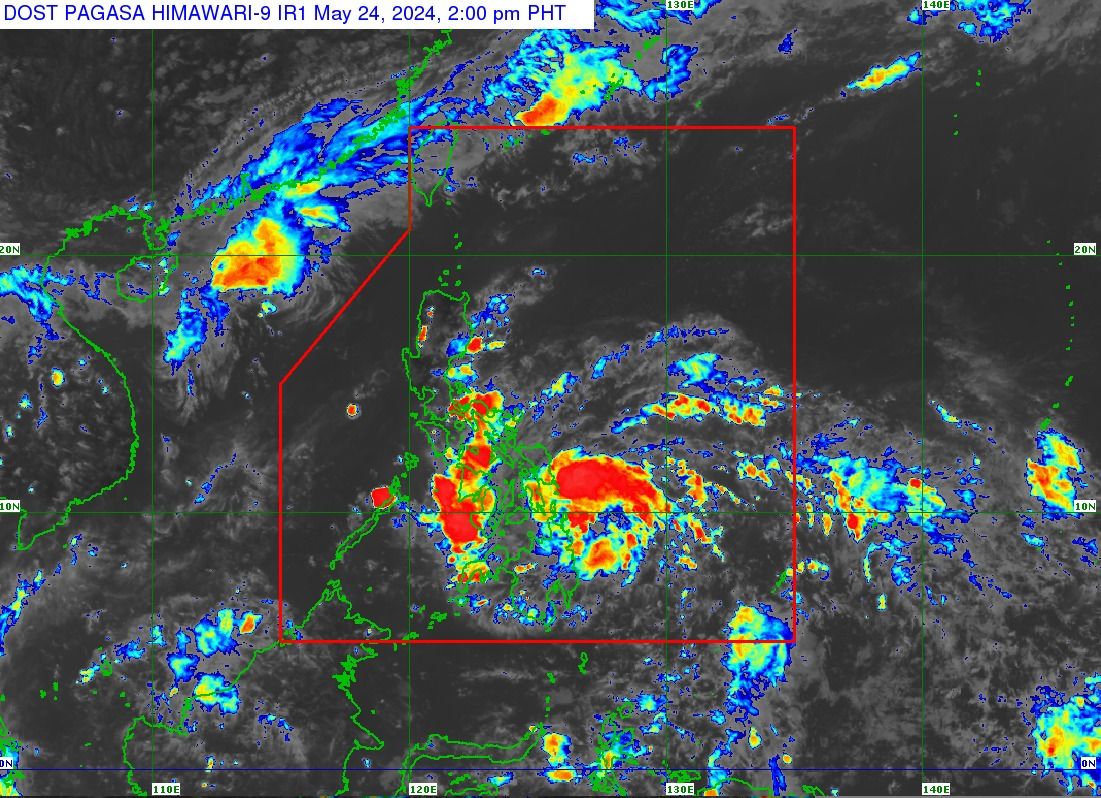
Tropical depression “Aghon” intensified slightly off the coast of Surigao del Sur, prompting the Philippine Atmospheric, Geophysical and Astronomical Services Administration (PAGASA) to issue Tropical Cyclone Wind Signal No. 1 over 18 areas on Friday afternoon, May 24.
In the PAGASA’s tropical cyclone bulletin issued at 2 p.m., Signal No. 1 was hoisted over Sorsogon, Albay, Catanduanes, Camarines Norte, Camarines Sur, Masbate, including Ticao and Burias Islands, Eastern Samar, Samar, Northern Samar, Leyte, Southern Leyte, Biliran, Camotes Islands, Dinagat Islands, Agusan del Norte, Agusan del Sur, Surigao del Sur, and Surigao del Norte, including Siargao and Bucas Grande Islands.
As Aghon approaches the country, more areas in Bicol Region, Eastern Visayas, and Caraga Region may be placed under Signal No. 1 in the next bulletin at 5 p.m.
PAGASA said the highest possible wind signal that may be hoisted during the passage of Aghon is Signal No. 2.
Potential landfall or near passage expected over E. Visayas
As of 1 p.m., the center of tropical depression Aghon was located 135 kilometers east-northeast of Hinatuan, Surigao del Sur, moving west-northwestward at 25 kilometers per hour (kph).
It has slightly intensified with maximum sustained winds of 55 kph near the center and gusts of up to 70 kph.
Based on its track forecast, PAGASA said Aghon may make a “close approach or landfall” over Eastern Visayas on Saturday morning, May 25.
In a press briefing on Friday morning, PAGASA Weather Specialist Benison Estareja said Aghon may intensify into a tropical storm as it approaches or makes landfall over Northern or Eastern Samar on Saturday morning.
After that, Aghon will pass north-northwestward over Eastern Visayas before emerging over the waters off the east coast of Bicol Region on Saturday evening as a tropical storm.
On Sunday, May 26, Aghon will begin “recurving” northeastward or north-northeastward over the waters east of Luzon, while gradually intensifying.
The current forecast scenario shows an intensification into a severe tropical storm by Sunday morning and into a typhoon by Monday, May 27.
PAGASA said that given the westward shift in Aghon’s track forecast and the forecast probability cone, “a slightly earlier landfall over Eastern Visayas and a direct passage in the vicinity of Bicol Region are not ruled out at this time.”
Rainfall forecast
PAGASA warned that Aghon could bring moderate to heavy rains (100 to 200 millimeters) to Albay, Sorsogon, Northern Samar, Eastern Samar, Southern Leyte, Surigao del Norte, and Dinagat Islands from Friday afternoon to Saturday afternoon.
Light to moderate rains, with occasional heavy rains, (50 to 100 millimeters) are also expected in Surigao del Sur, the rest of Eastern Visayas, Masbate including Ticao and Burias Islands, Catanduanes, the eastern portion of Camarines Sur, Western Visayas, and Zamboanga del Norte.
From Saturday afternoon to Sunday afternoon, moderate to heavy rains may continue in Bicol Region and Northern Samar, while light to moderate to, at times, heavy rains may persist in the rest of Eastern Visayas and the southern portion of Quezon province, including Polillo Islands.
From Sunday afternoon to Monday afternoon, Catanduanes, Camarines Norte, and Camarines Sur may experience light to moderate rains, with occasional heavy rains.
PAGASA said Aghon may also cause moderate to rough seas along the northern and eastern seaboards of Eastern Visayas, as well as the eastern seaboard of Caraga Region.
Mariners of motor bancas and similar-sized vessels are advised to exercise caution when venturing out to sea and, if possible, avoid navigating in these conditions, particularly if inexperienced or operating ill-equipped vessels.
Estareja said Aghon may leave the country’s area of responsibility on Tuesday, May 28.