


 Philippines
National
'Aghon' may make landfall in next 12 hours; 20 areas under Signal No. 1
Philippines
National
'Aghon' may make landfall in next 12 hours; 20 areas under Signal No. 1
'Aghon' may make landfall in next 12 hours; 20 areas under Signal No. 1


At A Glance
- PAGASA said Aghon will continue to move northwestward and is expected to make landfall as a tropical depression near Eastern Samar in the next 12 hours, most likely by Saturday early morning, May 25.
- However, due to the westward shift in its track, there is an increasing possibility of landfall in the vicinity of Leyte and/or Dinagat Islands within the next 12 hours.
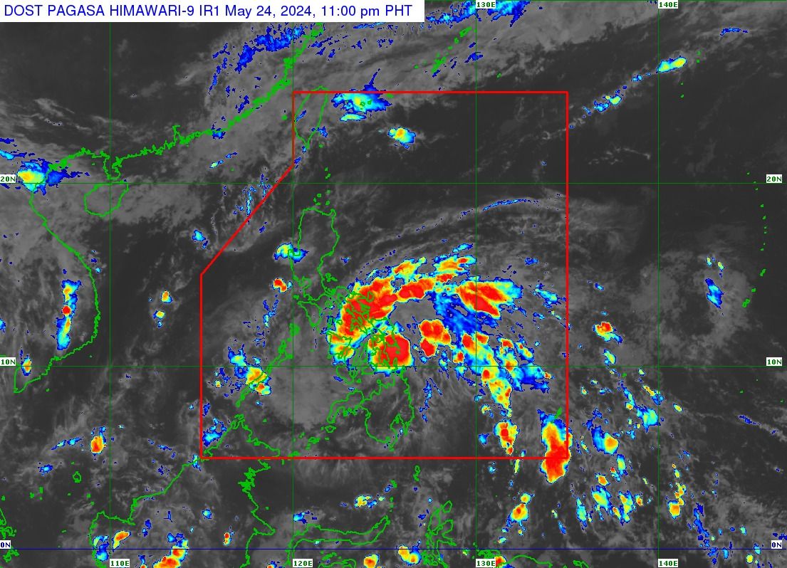
Tropical Cyclone Wind Signal No. 1 has been raised over 20 areas as tropical depression “Aghon” is anticipated to make landfall within the next 12 hours, the Philippine Atmospheric, Geophysical and Astronomical Services Administration (PAGASA) said on Friday evening, May 24.
In the PAGASA’s tropical cyclone bulletin issued at 11 p.m., Signal No. 1 was hoisted over the southeastern portion of Quezon, Camarines Norte, Camarines Sur, Catanduanes, Albay, Sorsogon, Masbate including Burias and Ticao Islands, Northern Samar, Samar, Eastern Samar, Biliran, Leyte, Southern Leyte, the extreme northern portion of Cebu including Camotes and Bantayan Islands, the northeastern portion of Bohol, Dinagat Islands, Surigao del Norte including Siargao and Bucas Grande Islands, Surigao del Sur, Agusan del Norte, and the eastern portion of Agusan del Sur.
As Aghon approaches the country, it is expected that some areas in Calabarzon (Cavite, Laguna, Batangas, Rizal, Quezon) will be placed under Signal No. 1 in the next bulletin at 2 a.m., Saturday, May 25.
PAGASA said the highest possible wind signal that may be hoisted during the passage of Aghon is Signal No. 2.
Landfall
As of 10 p.m., tropical depression Aghon was located 145 kilometers east of Surigao City, Surigao del Norte, moving northwest at 20 kilometers per hour (kph).
It has maintained its maximum sustained winds of 55 kph near the center and gusts of up to 70 kph.
PAGASA said Aghon will continue to move northwestward and is expected to make landfall as a tropical depression near Eastern Samar in the next 12 hours, most likely by Saturday early morning.
However, due to the westward shift in its track, there is an increasing possibility of landfall in the vicinity of Leyte and/or Dinagat Islands within the next 12 hours.
PAGASA said Aghon will then continue to move northwestward, emerging over the Samar Sea and crossing the Bicol Peninsula between Saturday afternoon and Sunday early morning, May 26.
It is expected to emerge over the waters north of Camarines Norte and Camarines Sur by Sunday morning.
PAGASA added that Aghon may intensify into a tropical storm between the time it emerges over the Samar Sea and when it passes through the Bicol Region.
On Sunday, Aghon will start its “recurvature” towards the northeast, or away from the country.
As it moves across the Philippine Sea, it is expected to intensify further and become a typhoon on Tuesday, May 28.
Based on the forecast, Aghon may leave the country’s area of responsibility no earlier than Tuesday.