


 Philippines
Luzon
More to come? Davao de Oro landslide not the first, won't be the last
Philippines
Luzon
More to come? Davao de Oro landslide not the first, won't be the last
More to come? Davao de Oro landslide not the first, won't be the last


DAVAO CITY – The massive landslide that hit Barangay Masara, Maco, Davao de Oro was not the first and may not be the last.
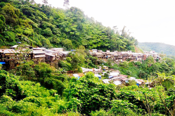
A SMALL-scale mining community in Pantukan, Davao de Oro. (Keith Bacongco)
The lure of gold has drawn not just giant mining firms in the mineral-rich province of Davao de Oro and Davao Oriental but also small-scale miners, too.
However, over the years, landslides have turned many of these mining sites into permanent graveyards of both miners and residents.
As they dig gold, they are also digging their own graves.
In the last 15 years, deadly landslides have taken place in mining sites in the hinterlands of Maco, Monkayo, and Pantukan towns in Davao de Oro.
Many of these deadly landslides took place in gold-rush sites where miners and people cram in shanties that stood on the ridges and steep slopes.
One of the most deadly landslides to hit Davao de Oro, then known as Compostela Valley province, was in the gold-rush village of Napnapan in Pantukan in January 2012.
At least 36 bodies were retrieved and about 40 others were reported missing after a landslide buried dozens of houses in Sitio Diat Uno in Barangay Napnapan.
Three years earlier, at least 26 miners and residents were also killed due a massive landslide in the same village.
Last January 18, 11 persons were killed in a landslide that hit the gold-rush village of Mount Diwata, popularly known as Diwalwal, in Monkayo.
Like Pantukan, the mountainous village of Diwalwal had been a site of deadly landslides for many years.
From 2005 to 2007, the landslides in Diwalwal due to heavy rains have killed almost 50 persons, according to reports.
On February 6, a massive landslide swathed the mining village of Masara.
Responders are now racing against time to find more survivors as the search, rescue, and retrieval operation have been extended for another 48 hours or until Saturday night, February 10, and a decision will be made afterwards if this will shift to retrieval.
Provincial Disaster Risk Reduction and Management Office spokesperson Edward Macapili said that responders remain hopeful to find more survivors following the recovery of a three-year old girl three days after the landslide on Friday morning, February 9.
As of 6 p.m. on Saturday, February 10, the Maco Municipal Disaster Risk Reduction and Management Office reported that 35 have been retrieved from the landslide site. Seventy-seven persons are still missing with 32 survivors.
At least 55 houses were said to be buried under dirt and debris.
Masara, which has just over 1,000 residents, is one of the host communities of mining firm Apex Mining Co. that has two Mineral Production Sharing Agreements (MPSA) based on Mines and Geosciences Bureau (MGB) records.
No build zones
Based on the website HazardHunterPH, Davao Oro has been tagged as highly susceptible to rain-induced landslides.
The province is barely visible on the map when ticking the rain-induced landslides under the hydro-meteorological hazard category.
HazardHunterPH is the country's one-stop shop for hazard assessment that can be used to generate indicative hazard assessment reports on the user's specified location.
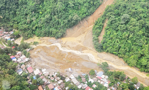
THE Mines and Geosciences Bureau estimates that the landslide in Barangay Masara, Maco, Davao de Oro from crown to foot is about nine hectares and 700 meters long. (OCD-Davao region)
The interactive online tool is a product of GeoRisk Philippines, a multi-agency initiative led by the Philippine Institute of Volcanology and Seismology (Phivolcs) funded by the Department of Science and Technology (DOST).
MGB-Davao Geosciences Division chief Beverly Brebante confirmed that the Barangay Masara is one of the villages in the province that has long been tagged as no build zones for at least a decade now.
In an online multi-agency press briefing, Brebante added that technical data has been relayed to the local government units and recommended relocating villagers to safe zones.
She assured that MGB will assist local government units in finding relocation sites.
Davao de Oro Gov. Dorothy Gonzaga confirmed Masara and other barangays were indeed declared as no-build zones long before she was elected in 2022.
Gonzaga blamed the MGB for not providing a definite area for relocation.
Due to the deadly landslide, the governor vowed not to allow anymore the displaced residents in Masara and other identified no-build zone areas.
Most of these high-risk areas are not just covered by the large-scale mining permits but also hosts small-scale mining operations.
MGB data said nine of the 13 identified “Minahang Bayan” or people’s small-scale mining area in the Davao region are in Davao de Oro and the rest are in Davao Oriental.
Minahang Bayan is a pocket mining site granted by the government to small-scale miners to extract minerals in certain areas.
Many of these Minahang Bayan in Davao de Oro are in Maco and Pantukan.
Aside from Apex Mining Co., five other large-scale mining firms hold MPSA permits. Under the MPSA, the mining firms are allowed to explore, extract, and develop up to 5,000 hectares.
Office of Civil Defense-Davao chief Ednar Dayanghirang said that the MGB has released geohazard maps to local governments and conducted widespread awareness campaigns to the public.
Dayanghirang said it is up to the local government to transform these geohazard data into governance.
He added that the local government and concerned government agencies have long been reminding the villagers of the risks within the identified geohazard areas.
The OCD official, who visited the landslide site on Thursday, February 8, said that many residents in Masara have left the village a few years ago since it was declared a no habitation zone by the MGB.
But Dayanghirang said that villagers returned to Masara because their livelihood depended on the mining operation in the area.
Ground Zero, he said, is a barangay site due to the presence of the barangay hall, church, small businesses, and residential community.
He said that why the habitation was still allowed amid the risk cannot be resolved by finger pointing. “There should be a dialogue among LGU officials, concerned government agencies, and other stakeholders. We all know what is the problem. We should come up with solutions to the problem.”
History of landslides in Maco
The massive landslide on February 6 was not the first time that happened in the second-class town of 83,000 people.
In 2007, at least 10 people were killed in the landslide in Masara due to heavy rains. A year later, 24 miners and villagers were also killed in a landslide in Masara.
Prior to the landslide last February 6, pictures and videos circulated on social media showed that a minor landslide had occurred in the area.
Engr. Ferdinand Dobli, Apex Mining Co. community relations manager, confirmed that there were flooding and minor landslides that took place in the area.
Dobli said that the firm prepared an emergency response team should the situation worsen. However, he did not answer why no preemptive evacuation was conducted.
A Municipal Disaster Risk Reduction Management Office personnel from Maco said they did not receive any report of a landslide in Masara on January 31 or February 1.
In an interview with an online news outfit on February 9, Gonzaga said they did not receive a report that a landslide happened prior to February 6. “Had we learned about it, we could have enforced a preemptive evacuation,” Gonzaga said in an interview with Davao-based Newsline Philippines.
Dayanghirang said that he had spoken to some of the displaced villagers in Masara and admitted that there were minor landslides prior to the February 6 landslide.
Landslide site is within mining tenement
Apex Mining Co. emphasized in press statements following the incident that the landslide happened outside of its area of operations.
But Teresa Pacis, Apex Mining Co. assistant vice president for corporate Affairs and communication, said on February 8 that the landslide site in Barangay Masara is within their mining tenement.

THE landslide site in Sitio Diat Uno, Barangay Napnapan, Pantukan, Compostela Valley in January 2012. (Keith Bacongco)
Pacis said the landslide site is far from their actual mining site where tunnels and drilling operations are located.
She added that the area only serves as a terminal for its buses that ferry workers in and out of the mining site.
Dobli said that the landslide site is about a kilometer away from their area of operation.
MGB data said Apex Mining Co. operates a gold mine in Maco under two 25-year MPSA covering at least 2,000 hectares. These MPSAs are set to expire in 2030 and 2032.
According to its 2022 annual report, it adopts underground trackless and conventional mining methods and employs the carbon-in-leach gold extraction process.
"The drilling activity completed 27 underground drill holes and six surface drill holes with an aggregate drilling meterage of 14,991 drilling-meters," the operational report stated.
Possibility of more landslides
Dayanghirang said that despite the risk in mining sites, many villagers still took the risk for economic reasons.
He warned that a possibility of another landslide is still there due to susceptibility of the area.
The landslides in the area were due to the continuous rains since January, Brebante said.
Brebante said that the most recent landslide in Masara was due to natural causes as she belied reports that it was due to the mining activities in the area.
The MGB official added that the area is already considered critical as the soil and rocks are already loose due to its proximity to the Philippine Fault.
Brebante said that the landslide site is estimated to be around nine hectares and about 700 meters long.
During the aerial survey, she bared that the MGB has noted several active landslides around Masara.
Brebante said they are still conducting assessments in the area but emphasized that the landslide sites are now considered critical.