ADVERTISEMENT

'Nika' intensifies, moves westward over Philippine Sea near Bicol Region — PAGASA

Published Nov 9, 2024 03:54 pm

Tropical Storm (TS) Nika (international name: Toraji) has further intensified as it moves westward over the Philippine Sea, east of the Bicol Region, according to the Philippine Atmospheric, Geophysical, and Astronomical Services Administration (PAGASA).

11pm.jpg
(Courtesy of PAGASA) 

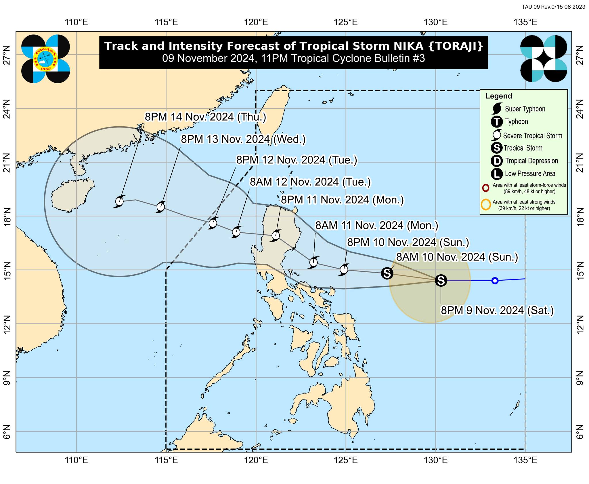
In its 11 p.m. bulletin issued on Saturday, Nov. 9, PAGASA located the center of “Nika” 625 km east of Virac, Catanduanes, or 750 km east of Daet, Camarines Norte.

PAGASA reported that TS Nika has maximum sustained winds of 75 kilometers per hour (km/h) near the center, gustiness of up to 90 km/h, and a central pressure of 998 hPa.

“Nika” is moving westward at 20 km/h, PAGASA noted. Strong to gale-force winds extend outward up to 300 km from the center, it added.

Tropical Cyclone Wind Signals

TCWS No. 1 has been raised over parts of Luzon, including Isabela, Quirino, the eastern portion of Nueva Vizcaya (Kasibu, Alfonso Castaneda, Dupax del Norte, Diadi, Quezon), Aurora, the eastern portion of Nueva Ecija (Bongabon, Gabaldon, General Tinio, Laur), the eastern portion of Bulacan (Doña Remedios Trinidad, Norzagaray), and the eastern portion of Quezon (Calauag, Guinayangan, Tagkawayan, Pitogo, San Andres, Buenavista, San Francisco, Pagbilao, Infanta, Lopez, Catanauan, Mulanay, Unisan, General Luna, Plaridel, Quezon, Alabat, Sampaloc, Padre Burgos, Macalelon, Mauban, Perez, Agdangan, Gumaca, Atimonan, Real, San Narciso, General Nakar), including the Polillo Islands, Camarines Norte, Camarines Sur, Catanduanes, and the northeastern portion of Albay (Malinao, Tiwi, Bacacay, City of Tabaco, Malilipot, Rapu-Rapu).

Heavy rainfall outlook

PAGASA has also issued a heavy rainfall outlook due to “Nika.”

On Sunday, Nov. 10, PAGASA said moderate to heavy rainfall (50–100 mm) is expected in Catanduanes.

From Nov. 10 to Monday, Nov. 11, PAGASA said intense to torrential rainfall (>200 mm) is expected in Isabela and Aurora; heavy to intense rainfall (100–200 mm) in Cagayan and Quirino; and moderate to heavy rainfall (50–100 mm) in Catanduanes, the Cordillera Administrative Region, Nueva Vizcaya, Quezon, Camarines Norte, and Camarines Sur.
Intense to torrential rains may affect Apayao and Kalinga, heavy to intense rains are expected in Cagayan, Abra, Mountain Province, Ifugao, Ilocos Norte, and Ilocos Sur, and moderate to heavy rainfall is expected in La Union, Benguet, Aurora, and the rest of Cagayan Valley from Nov. 11 to Tuesday, Nov. 12 according to PAGASA.

During intense torrential rainfall, PAGASA said widespread incidents of severe flooding and landslides are expected. Numerous flooding events are likely, particularly in urbanized, low-lying areas, or regions near rivers. Landslides are likely in moderate to highly susceptible areas.

For areas with moderate to heavy rains, PAGASA said localized flooding is possible, especially in urbanized or low-lying areas near rivers. Landslides may also occur in highly susceptible areas, it added.

Signal No. 4 'not ruled out' 

PAGASA said that the highest wind signal likely to be issued during “Nika” is Wind Signal No. 3.

“However, the hoisting of Wind Signal No. 4 is not ruled out,” it added.

PAGASA said “Nika” will continue moving west-northwestward throughout the forecast period. According to the track forecast, “Nika” may make landfall over Isabela or Aurora on the afternoon or evening of Nov. 11.

“Regardless of the specific landfall location, it is important to note that hazards may still impact areas outside the landfall point or within the forecast confidence cone,” PAGASA said.

The weather bureau added that “Nika” is expected to continue intensifying and may reach severe tropical storm status by Nov. 10. “Nika” may reach peak intensity before landfall, with the possibility of rapid intensification while over the Philippine Sea east of Quezon.

A brief period of weakening is anticipated as “Nika” crosses the Luzon landmass due to land interaction, PAGASA said. However, “Nika” is expected to remain a severe tropical storm throughout the forecast period, it added.

RELATED STORY:

https://mb.com.ph/2024/11/9/nika-intensifies-into-a-tropical-storm

Related Tags

Philippines weather PAGASA NikaPH NIKAPH
ADVERTISEMENT
.most-popular .layout-ratio{ padding-bottom: 79.13%; } @media (min-width: 768px) and (max-width: 1024px) { .widget-title { font-size: 15px !important; } }

{{ articles_filter_1561_widget.title }}

.most-popular .layout-ratio{ padding-bottom: 79.13%; } @media (min-width: 768px) and (max-width: 1024px) { .widget-title { font-size: 15px !important; } }

{{ articles_filter_1562_widget.title }}

.most-popular .layout-ratio{ padding-bottom: 79.13%; } @media (min-width: 768px) and (max-width: 1024px) { .widget-title { font-size: 15px !important; } }

{{ articles_filter_1563_widget.title }}

{{ articles_filter_1564_widget.title }}

.mb-article-details { position: relative; } .mb-article-details .article-body-preview, .mb-article-details .article-body-summary{ font-size: 17px; line-height: 30px; font-family: "Libre Caslon Text", serif; color: #000; } .mb-article-details .article-body-preview iframe , .mb-article-details .article-body-summary iframe{ width: 100%; margin: auto; } .read-more-background { background: linear-gradient(180deg, color(display-p3 1.000 1.000 1.000 / 0) 13.75%, color(display-p3 1.000 1.000 1.000 / 0.8) 30.79%, color(display-p3 1.000 1.000 1.000) 72.5%); position: absolute; height: 200px; width: 100%; bottom: 0; display: flex; justify-content: center; align-items: center; padding: 0; } .read-more-background a{ color: #000; } .read-more-btn { padding: 17px 45px; font-family: Inter; font-weight: 700; font-size: 18px; line-height: 16px; text-align: center; vertical-align: middle; border: 1px solid black; background-color: white; } .hidden { display: none; }
function initializeAllSwipers() { // Get all hidden inputs with cms_article_id document.querySelectorAll('[id^="cms_article_id_"]').forEach(function (input) { const cmsArticleId = input.value; const articleSelector = '#article-' + cmsArticleId + ' .body_images'; const swiperElement = document.querySelector(articleSelector); if (swiperElement && !swiperElement.classList.contains('swiper-initialized')) { new Swiper(articleSelector, { loop: true, pagination: false, navigation: { nextEl: '#article-' + cmsArticleId + ' .swiper-button-next', prevEl: '#article-' + cmsArticleId + ' .swiper-button-prev', }, }); } }); } setTimeout(initializeAllSwipers, 3000); const intersectionObserver = new IntersectionObserver( (entries) => { entries.forEach((entry) => { if (entry.isIntersecting) { const newUrl = entry.target.getAttribute("data-url"); if (newUrl) { history.pushState(null, null, newUrl); let article = entry.target; // Extract metadata const author = article.querySelector('.author-section').textContent.replace('By', '').trim(); const section = article.querySelector('.section-info ').textContent.replace(' ', ' '); const title = article.querySelector('.article-title h1').textContent; // Parse URL for Chartbeat path format const parsedUrl = new URL(newUrl, window.location.origin); const cleanUrl = parsedUrl.host + parsedUrl.pathname; // Update Chartbeat configuration if (typeof window._sf_async_config !== 'undefined') { window._sf_async_config.path = cleanUrl; window._sf_async_config.sections = section; window._sf_async_config.authors = author; } // Track virtual page view with Chartbeat if (typeof pSUPERFLY !== 'undefined' && typeof pSUPERFLY.virtualPage === 'function') { try { pSUPERFLY.virtualPage({ path: cleanUrl, title: title, sections: section, authors: author }); } catch (error) { console.error('ping error', error); } } // Optional: Update document title if (title && title !== document.title) { document.title = title; } } } }); }, { threshold: 0.1 } ); function showArticleBody(button) { const article = button.closest("article"); const summary = article.querySelector(".article-body-summary"); const body = article.querySelector(".article-body-preview"); const readMoreSection = article.querySelector(".read-more-background"); // Hide summary and read-more section summary.style.display = "none"; readMoreSection.style.display = "none"; // Show the full article body body.classList.remove("hidden"); } document.addEventListener("DOMContentLoaded", () => { let loadCount = 0; // Track how many times articles are loaded const offset = [1, 2, 3, 4, 5, 6, 7, 8, 9, 10]; // Offset values const currentUrl = window.location.pathname.substring(1); let isLoading = false; // Prevent multiple calls if (!currentUrl) { console.log("Current URL is invalid."); return; } const sentinel = document.getElementById("load-more-sentinel"); if (!sentinel) { console.log("Sentinel element not found."); return; } function isSentinelVisible() { const rect = sentinel.getBoundingClientRect(); return ( rect.top < window.innerHeight && rect.bottom >= 0 ); } function onScroll() { if (isLoading) return; if (isSentinelVisible()) { if (loadCount >= offset.length) { console.log("Maximum load attempts reached."); window.removeEventListener("scroll", onScroll); return; } isLoading = true; const currentOffset = offset[loadCount]; window.loadMoreItems().then(() => { let article = document.querySelector('#widget_1690 > div:nth-last-of-type(2) article'); intersectionObserver.observe(article) loadCount++; }).catch(error => { console.error("Error loading more items:", error); }).finally(() => { isLoading = false; }); } } window.addEventListener("scroll", onScroll); });

Sign up by email to receive news.