Signal No. 3 raised over 3 Luzon areas as 'Marce' approaches Cagayan
At A Glance
- Typhoon Marce may make landfall or pass very close to the Babuyan Islands or northern mainland Cagayan, before moving over Ilocos Norte and Apayao from Thursday afternoon to early Friday morning.
- The highest wind warning that may be issued during the passage of Marce is Signal No. 4.
- PAGASA also warned of heavy rainfall due to the approaching typhoon.

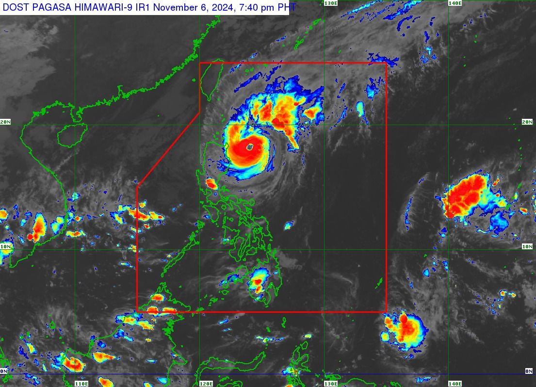
The Philippine Atmospheric, Geophysical, and Astronomical Services Administration (PAGASA) said Typhoon “Marce” (international name: Yinxing) continues to pose a threat as it approaches the northern part of mainland Cagayan and Babuyan Islands on Wednesday evening, Nov. 6.
As of 7 p.m., the center of the typhoon was located 260 kilometers east of Aparri, Cagayan, with maximum sustained winds of 150 kilometers per hour (kph) and gusts reaching 185 kph.
In preparation for Marce’s severe winds, PAGASA, in its 8 p.m. bulletin, has raised Signal No. 3 over the northern portion of mainland Cagayan (Santa Ana, Gonzaga, Lal-Lo, Santa Teresita, Buguey, Aparri, Camalaniugan, Allacapan, Gattaran, Lasam, Ballesteros, Baggao, Alcala, Santo Niño, Rizal, Abulug, Pamplona), southern portion of Babuyan Islands (Fuga Island, Camiguin Island), and eastern portion of Apayao (Flora, Santa Marcela, Luna, Pudtol).
Signal No. 2 remains in effect in Batanes, the rest of Babuyan Islands, the rest of mainland Cagayan, northern portion of Isabela (San Pablo, Santa Maria, Divilacan, Tumauini, Maconacon, Cabagan, Santo Tomas, Quezon, Palanan, Ilagan City, Mallig, Delfin Albano, Quirino), the rest of Apayao, Abra, Kalinga, Ilocos Norte, and northern portion of Ilocos Sur (Sinait, Cabugao, San Juan, Magsingal, Santo Domingo, Bantay, San Ildefonso, San Vicente, Santa Catalina, City of Vigan, Narvacan, Caoayan, Santa, Nagbukel, Santa Maria, San Esteban, Santiago, Burgos, Banayoyo, Lidlidda, San Emilio).
Meanwhile, Signal No. 1 is still in effect over the rest of Ilocos Sur, La Union, northwestern portion of Pangasinan (Bani, Bolinao, Anda, City of Alaminos, Agno, Sual), Mountain Province, Ifugao, Benguet, the rest of Isabela, Quirino, Nueva Vizcaya, and northern portion of Aurora (Dilasag, Casiguran, Dinalungan, Dipaculao, Maria Aurora, Baler).
The highest wind warning that may be issued during the passage of Marce is Signal No. 4.

PAGASA also warned of heavy rainfall due to the approaching typhoon.
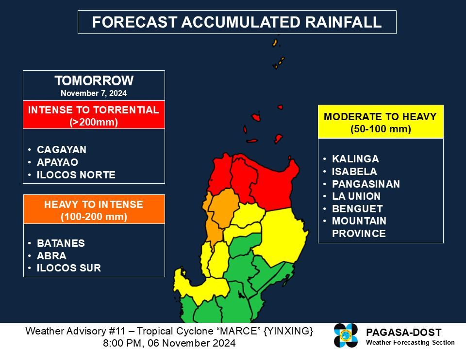
From Wednesday evening to Thursday evening, Nov. 7, intense to torrential rainfall (over 200 millimeters) may affect Cagayan, Apayao, and Ilocos Norte.
Heavy to intense rainfall (100 to 200 millimeters) may also affect Batanes and Abra.
Meanwhile, moderate to heavy rainfall (50 to 100 millimeters) may continue over Kalinga, Isabela, Ilocos Sur, and Aurora.
PAGASA warned that moderate to torrential rainfall will persist in these areas through Friday, Nov. 8.
Forecast track, intensity
Currently moving slowly northwestward, Marce is expected to maintain this track over the waters east of Cagayan before gradually accelerating westward on Thursday through Saturday, Nov. 9, over the Babuyan Channel and the northern portion of the West Philippine Sea.
Marce may make landfall or pass very close to the Babuyan Islands or northern mainland Cagayan, before moving over Ilocos Norte and Apayao from Thursday afternoon to early Friday morning.
The typhoon is expected to exit the Philippine Area of Responsibility (PAR) by Friday evening.
PAGASA said a slight weakening is expected due to possible interaction with the terrain of mainland Luzon during the landfall or close approach of Marce. However, it may remain a typhoon until it exits the PAR.
The surge of the northeasterly wind flow will trigger a further weakening of the typhoon over the weekend, it added.