'Marce' intensifies further, poses major threat to northern Luzon; Signal No. 3 raised
At A Glance
- The highest wind warning, which may be issued during the passage of Marce is Signal No. 4.
- PAGASA Assistant Weather Services Section Chief Chris Perez said the "critical period" will be on Thursday when the center of the typhoon is expected to be closest to Batanes or Cagayan.
- After landfall, Marce may continue to traverse Ilocos Norte and Apayao.

The Philippine Atmospheric, Geophysical and Astronomical Services Administration (PAGASA) warned on Wednesday, Nov. 6, that Typhoon “Marce” (international name: Yinxing) has continued to intensify and is still on track to hit northern Luzon by Thursday, Nov. 7.
“Pinapayuhan natin ang ating mga kababayan na seryosohin ang pagresponde sa bagyong Marce habang papalapit ito sa northern Luzon at patuloy na lumalakas, upang maiwasan ang malubhang epekto nito (We urge our fellow citizens to take Typhoon Marce seriously as it approaches northern Luzon and continues to intensify, in order to avoid its severe impact),” PAGASA Administrator Nathaniel Servando said in a press conference.
“May taglay itong hazards. Una ‘yung severe winds, malalakas na hangin, kaya nakaraise na ang Signal No. 3 sa may northern portion ng mainland Cagayan (It carries several hazards, including severe winds, which have prompted the issuance of Signal No. 3 in the northern portion of mainland Cagayan),” he added.
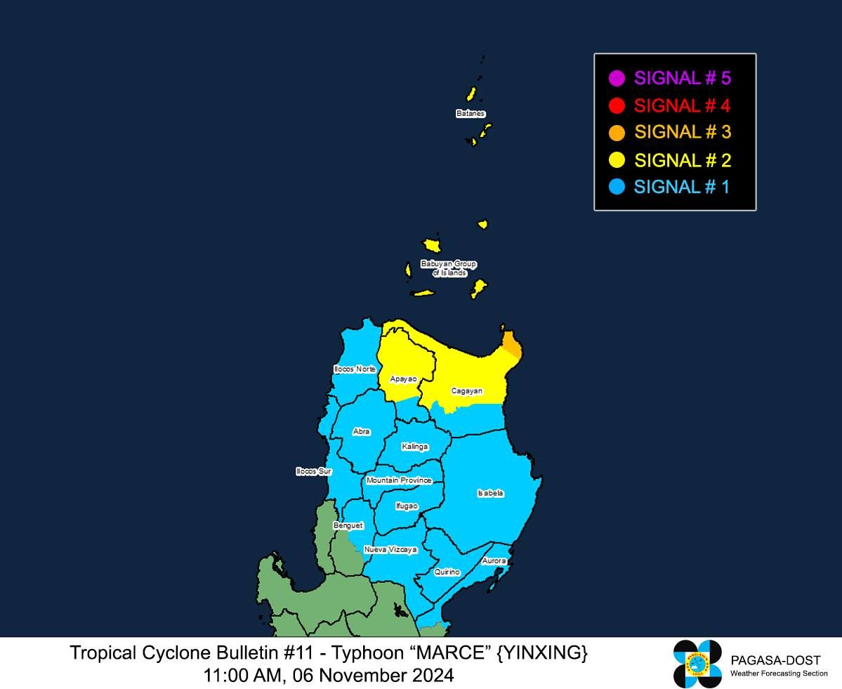
In its 11 a.m. bulletin, PAGASA has raised Signal No. 3 in the northeastern portion of mainland Cagayan (Santa Ana).
Signal No. 2 is also up over Batanes, Babuyan Islands, northern portion of mainland Cagayan (Gonzaga, Lal-Lo, Santa Teresita, Buguey, Gattaran, Baggao, Lasam, Abulug, Camalaniugan, Pamplona, Claveria, Aparri, Ballesteros, Allacapan, Sanchez-Mira, Santa Praxedes, Rizal, Santo Niño, Alcala, Amulung), and northern portion of Apayao (Calanasan, Luna, Pudtol, Santa Marcela, Flora, Kabugao).
Signal No. 1 remains in effect in Ilocos Norte, Ilocos Sur, Abra, the rest of Apayao, Kalinga, Mountain Province, Ifugao, northern portion of Benguet (Mankayan, Buguias, Kabayan, Bakun, Kibungan, Bokod, Atok), the rest of mainland Cagayan, Isabela, Quirino, Nueva Vizcaya, and northern portion of Aurora (Dilasag, Casiguran, Dinalungan, Dipaculao, Maria Aurora, Baler).
The highest wind warning, which may be issued during the passage of Marce is Signal No. 4.
PAGASA also warned of heavy rains due to the approaching typhoon.
“Inaasahan natin na lalakas pa ang mga pag-ulan habang ito ay patuloy na kumikilos malapit sa mainland Luzon, particularly sa northern part ng Luzon (We anticipate that rainfall will intensify as the typhoon continues its movement toward mainland Luzon, particularly in the northern part of Luzon),” Servando said.
“Naglabas kami ng rainfall advisories dahil inaasahan namin ang malalakas na ulan simula ngayong araw lalong-lalo na sa Cagayan na inaasahan ang heavy to intense rains from 100 to 200 millimeters at moderate to heavy rains naman sa Batanes, Isabela, at Apayao (We have issued rainfall advisories as we expect intense rainfall starting today, especially in Cagayan, where rainfall amounts may reach 100 to 200 millimeters. Moderate to heavy rains are also expected in Batanes, Isabela, and Aurora),” he added.
Servando warned that areas that have experienced recent significant rainfall are also at risk of flooding and landslides.
Landfall possible
As of 10 a.m., the center of the typhoon was located 305 kilometers east of Tuguegarao City, Cagayan, or 315 kilometers east of Aparri, Cagayan, with maximum sustained winds of 150 kilometers per hour (kph) near its center and gusts reaching 185 kph.
PAGASA Assistant Weather Services Chief Chris Perez added that Marce has been moving westward at 10 kph over the past six hours, generally toward northern Luzon.
He pointed out that the critical period will be on Thursday when the center of the typhoon is expected to be closest to Batanes or Cagayan.
Residents in these areas should remain prepared for a possible landfall, and even those in areas under wind warnings need to stay alert, he added.
After landfall, Marce may continue to traverse Ilocos Norte and Apayao, PAGASA warned.
“Over the next three days, we expect flooding, landslides, and severe winds that could damage infrastructure, power lines, and crops,” Perez said.
“As much as possible, everyone should prepare for the next two to three days and avoid going out,” he added.
PAGASA said Marce is expected to exit the Philippine area of responsibility by Friday evening, Nov. 8.