ADVERTISEMENT

Tropical storm enters PAR, named 'Marce'

Published Nov 3, 2024 11:19 pm

At A Glance

  • PAGASA said there is a "high uncertainty" regarding Marce's forecast track due to two possible scenarios—the storm may either shift westward towards extreme Northern Luzon or mainland Luzon, or it may move erratically over the Philippine Sea, east of extreme Northern Luzon.
  • A westward shift in track is likely within the next 24 hours due to a high-pressure area north of Marce, which may change the potential landfall area—from Babuyan Islands to Isabela.
  • The highest wind warning that may be issued in the coming days is Signal No. 4, should the storm intensify into a typhoon.
IMG_4494.jpeg
Forecast track and intensity of Tropical Storm Marce (international name: Yinxing) as of 5 a.m., Nov. 4, 2024 (Courtesy of PAGASA)

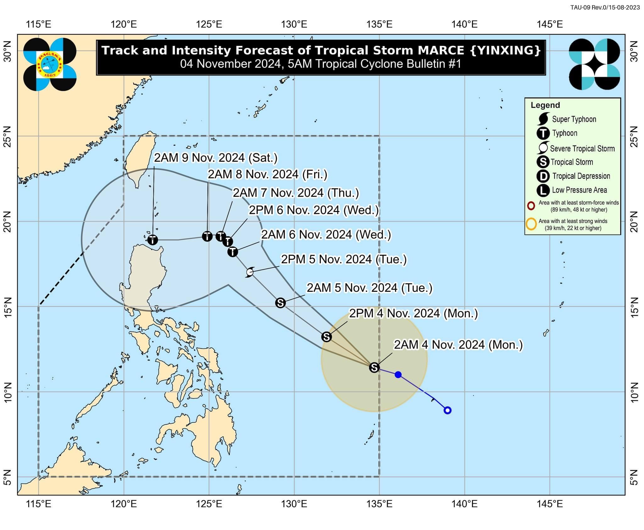
The Philippine Atmospheric, Geophysical and Astronomical Services Administration (PAGASA) said the tropical depression off Eastern Visayas intensified into a tropical storm upon entering the Philippine area of responsibility (PAR) on Monday morning, Nov. 4. It has been named “Marce,” making it the 13th tropical cyclone of 2024.

As of 4 a.m., the center of Marce (international name: Yinxing) was located 935 kilometers east of Eastern Visayas, with maximum sustained winds of 65 kilometers per hour (kph) and gusts reaching 80 kph.

The storm is moving west-northwestward at a speed of 25 kph.

PAGASA said Wind Signal No. 1 could be raised over parts of Cagayan by Tuesday, Nov. 5. The highest wind warning that may be issued in the coming days is Signal No. 4, should the storm intensify into a typhoon.

“As Marce moves northwestward within the PAR region, it may enhance the surge of northeasterly wind flow, which may occur within the week. This, and the trough of the tropical cyclone, will bring rains over extreme Northern Luzon and the eastern section of Luzon beginning Tuesday,” PAGASA said in its bulletin.

Forecast track

PAGASA said Marce is expected to move west-northwestward to northwestward until Wednesday morning, Nov. 6, before significantly slowing down and turning westward.

From Wednesday afternoon onward, the storm will likely move north-northwestward to westward at a slow pace over the Philippine Sea, east of extreme Northern Luzon.

PAGASA pointed out that there is a “high uncertainty” regarding this forecast due to two possible scenarios—the storm may either shift westward towards extreme Northern Luzon or mainland Luzon, or it may move erratically over the Philippine Sea, east of extreme Northern Luzon.

It added that a westward shift in track is likely within the next 24 hours due to a high-pressure area north of Marce, which may change the potential landfall area—from Babuyan Islands to Isabela.

Related Tags

PAGASA landfall Tropical Storm Marce Yinxing
ADVERTISEMENT
.most-popular .layout-ratio{ padding-bottom: 79.13%; } @media (min-width: 768px) and (max-width: 1024px) { .widget-title { font-size: 15px !important; } }

{{ articles_filter_1561_widget.title }}

.most-popular .layout-ratio{ padding-bottom: 79.13%; } @media (min-width: 768px) and (max-width: 1024px) { .widget-title { font-size: 15px !important; } }

{{ articles_filter_1562_widget.title }}

.most-popular .layout-ratio{ padding-bottom: 79.13%; } @media (min-width: 768px) and (max-width: 1024px) { .widget-title { font-size: 15px !important; } }

{{ articles_filter_1563_widget.title }}

{{ articles_filter_1564_widget.title }}

.mb-article-details { position: relative; } .mb-article-details .article-body-preview, .mb-article-details .article-body-summary{ font-size: 17px; line-height: 30px; font-family: "Libre Caslon Text", serif; color: #000; } .mb-article-details .article-body-preview iframe , .mb-article-details .article-body-summary iframe{ width: 100%; margin: auto; } .read-more-background { background: linear-gradient(180deg, color(display-p3 1.000 1.000 1.000 / 0) 13.75%, color(display-p3 1.000 1.000 1.000 / 0.8) 30.79%, color(display-p3 1.000 1.000 1.000) 72.5%); position: absolute; height: 200px; width: 100%; bottom: 0; display: flex; justify-content: center; align-items: center; padding: 0; } .read-more-background a{ color: #000; } .read-more-btn { padding: 17px 45px; font-family: Inter; font-weight: 700; font-size: 18px; line-height: 16px; text-align: center; vertical-align: middle; border: 1px solid black; background-color: white; } .hidden { display: none; }
function initializeAllSwipers() { // Get all hidden inputs with cms_article_id document.querySelectorAll('[id^="cms_article_id_"]').forEach(function (input) { const cmsArticleId = input.value; const articleSelector = '#article-' + cmsArticleId + ' .body_images'; const swiperElement = document.querySelector(articleSelector); if (swiperElement && !swiperElement.classList.contains('swiper-initialized')) { new Swiper(articleSelector, { loop: true, pagination: false, navigation: { nextEl: '#article-' + cmsArticleId + ' .swiper-button-next', prevEl: '#article-' + cmsArticleId + ' .swiper-button-prev', }, }); } }); } setTimeout(initializeAllSwipers, 3000); const intersectionObserver = new IntersectionObserver( (entries) => { entries.forEach((entry) => { if (entry.isIntersecting) { const newUrl = entry.target.getAttribute("data-url"); if (newUrl) { history.pushState(null, null, newUrl); let article = entry.target; // Extract metadata const author = article.querySelector('.author-section').textContent.replace('By', '').trim(); const section = article.querySelector('.section-info ').textContent.replace(' ', ' '); const title = article.querySelector('.article-title h1').textContent; // Parse URL for Chartbeat path format const parsedUrl = new URL(newUrl, window.location.origin); const cleanUrl = parsedUrl.host + parsedUrl.pathname; // Update Chartbeat configuration if (typeof window._sf_async_config !== 'undefined') { window._sf_async_config.path = cleanUrl; window._sf_async_config.sections = section; window._sf_async_config.authors = author; } // Track virtual page view with Chartbeat if (typeof pSUPERFLY !== 'undefined' && typeof pSUPERFLY.virtualPage === 'function') { try { pSUPERFLY.virtualPage({ path: cleanUrl, title: title, sections: section, authors: author }); } catch (error) { console.error('ping error', error); } } // Optional: Update document title if (title && title !== document.title) { document.title = title; } } } }); }, { threshold: 0.1 } ); function showArticleBody(button) { const article = button.closest("article"); const summary = article.querySelector(".article-body-summary"); const body = article.querySelector(".article-body-preview"); const readMoreSection = article.querySelector(".read-more-background"); // Hide summary and read-more section summary.style.display = "none"; readMoreSection.style.display = "none"; // Show the full article body body.classList.remove("hidden"); } document.addEventListener("DOMContentLoaded", () => { let loadCount = 0; // Track how many times articles are loaded const offset = [1, 2, 3, 4, 5, 6, 7, 8, 9, 10]; // Offset values const currentUrl = window.location.pathname.substring(1); let isLoading = false; // Prevent multiple calls if (!currentUrl) { console.log("Current URL is invalid."); return; } const sentinel = document.getElementById("load-more-sentinel"); if (!sentinel) { console.log("Sentinel element not found."); return; } function isSentinelVisible() { const rect = sentinel.getBoundingClientRect(); return ( rect.top < window.innerHeight && rect.bottom >= 0 ); } function onScroll() { if (isLoading) return; if (isSentinelVisible()) { if (loadCount >= offset.length) { console.log("Maximum load attempts reached."); window.removeEventListener("scroll", onScroll); return; } isLoading = true; const currentOffset = offset[loadCount]; window.loadMoreItems().then(() => { let article = document.querySelector('#widget_1690 > div:nth-last-of-type(2) article'); intersectionObserver.observe(article) loadCount++; }).catch(error => { console.error("Error loading more items:", error); }).finally(() => { isLoading = false; }); } } window.addEventListener("scroll", onScroll); });

Sign up by email to receive news.