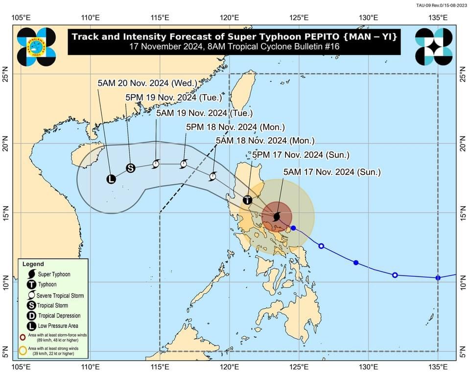
'Pepito' passes north of Calaguas Island, now moving over the sea east of Quezon — PAGASA

The Philippine Atmospheric, Geophysical and Astronomical Services Administration (PAGASA) said Super Typhoon “Pepito” (international name: Man-yi) is now over the coastal waters of Camarines Norte after passing north of Calaguas Islands on Sunday morning, Nov. 17.
In its 8 a.m. bulletin, PAGASA said Pepito is expected to pass near or move over Polillo Islands in the next few hours, before making another landfall over northern Quezon or central or southern Aurora between noon and afternoon.
The super typhoon currently has maximum sustained winds of 185 kilometers per hour (kph) near the center and gusts reaching 255 kph.
Wind warnings
As Pepito approaches Quezon province, PAGASA has raised Signal No. 5 over the eastern portion of Polillo Islands (Patnanungan, Jomalig) and Calaguas Islands, where extreme impacts from typhoon-force winds are expected.
Signal No. 4 is in effect over the northernmost portion of Camarines Sur (Siruma), the rest of Camarines Norte, northernportion of mainland Quezon (General Nakar, Infanta), the rest of Polillo Islands, central and southern portions of Aurora (Dingalan, San Luis, Maria Aurora, Baler, Dipaculao, Dinalungan), eastern portion of Nueva Ecija (General Tinio, Gabaldon, Laur, Bongabon, Palayan City, Pantabangan, Rizal, General Mamerto Natividad), southeastern portion of Nueva Vizcaya (Alfonso Castañeda), and southern portion of Quirino (Nagtipunan). Significant to severe impacts from typhoon-force winds may be felt in these areas.
Signal No. 3 also remains raised over the northern portion of Camarines Sur (Sipocot, Ragay, Magarao, Del Gallego, Libmanan, Naga City, Bombon, Lupi, Cabusao, Calabanga, Goa, San Jose, Lagonoy, Presentacion, Caramoan, Garchitorena, Tinambac, Canaman, Camaligan), western portion of Catanduanes (Caramoran, Pandan, San Andres), eastern portion of Quezon (Calauag, Guinayangan, Tagkawayan, Lopez, Quezon, Perez, Alabat, Gumaca, Plaridel, Atimonan, Mauban, Sampaloc, Real), eastern portion of Laguna (Santa Maria, Famy, Mabitac, Pakil, Pangil, Siniloan, Paete, Kalayaan, Lumban, Cavinti), eastern and central portions of Rizal (Pililla, Tanay, City of Antipolo, Rodriguez, Baras, San Mateo, Morong, Teresa), the rest of Aurora, eastern and central portions of Bulacan (Norzagaray, San Miguel, San Ildefonso, San Rafael, Doña Remedios Trinidad, Angat, City of San Jose del Monte, Santa Maria, Pandi, Baliuag, Bustos, Pulilan, Plaridel), northeastern portion of Pampanga (Candaba, Arayat, Magalang, San Luis, San Simon, Mexico, Santa Ana, Apalit, Santo Tomas, City of San Fernando, Mabalacat City, Angeles City), the rest of Nueva Ecija, Tarlac, northern portion of Zambales (Santa Cruz, Candelaria, Masinloc, Palauig), the rest of Nueva Vizcaya, the rest of Quirino, southern portion of Isabela (San Agustin, Jones, Echague, San Guillermo, Angadanan, Alicia, San Mateo, Ramon, San Isidro, City of Santiago, Cordon), central and southern portions of Ilocos Sur (Alilem, Sugpon, Cervantes, Suyo, Tagudin, Narvacan, Quirino, Sigay, Gregorio del Pilar, San Emilio, Santa Cruz, Salcedo, Banayoyo, City of Candon, Galimuyod, Santa Lucia, Lidlidda, Santa Maria, Burgos, Santiago, San Esteban, Nagbukel), La Union, Pangasinan, Benguet, Ifugao, western portion of Mountain Province (Sabangan, Bauko, Tadian, Bontoc, Sagada, Besao, Sadanga, Barlig), and southern portion of Abra (Tubo, Luba, Pilar, Villaviciosa, San Isidro). These areas may experience “moderate to significant impacts” from storm-force winds.
Areas under Signal No. 2 are Albay, northern portion of Marinduque (Santa Cruz, Boac, Mogpog, Torrijos), the rest of Quezon, the rest of Laguna, the rest of Rizal, Cavite, northern portion of Batangas (City of Tanauan, Santo Tomas, Talisay, Lipa City, Malvar, Balete, Mataasnakahoy, Laurel, Padre Garcia, San Juan, Rosario), Metro Manila, Bataan, the rest of Pampanga, the rest of Bulacan, the rest of Zambales, southwestern portion of Cagayan (Enrile, Tuao, Solana, Tuguegarao City, Piat, Rizal), the rest of Isabela, the rest of Abra, southern portion of Apayao (Conner, Kabugao), Kalinga, the rest of Mountain Province, the rest of Ilocos Sur, and southern portion of Ilocos Norte (Pinili, City of Batac, Banna, Nueva Era, Badoc, Currimao, Marcos, Solsona, Dingras, Sarrat, Paoay, Laoag City, San Nicolas). “Minor to moderate impacts” from gale-force winds are possible.
Meanwhile, Signal No. 1 is up in the northern portion of Masbate (City of Masbate, Mobo, Aroroy, Baleno, including Ticao and Burias Islands), the rest of Marinduque, northern portion of Romblon (Cajidiocan, San Fernando, Magdiwang, Romblon, Banton, Corcuera, Concepcion, San Andres, Calatrava, San Agustin), northern portion of Oriental Mindoro (Puerto Galera, San Teodoro, Naujan, Baco, Victoria, Socorro, Pinamalayan, Gloria, Pola, City of Calapan), northernportion of Occidental Mindoro (Sablayan, Santa Cruz, Mamburao, Abra de Ilog, Paluan, including Lubang Islands), the rest of Batangas, the rest of mainland Cagayan, the rest of Apayao, and the rest of Ilocos Norte. These areas may experience “minimal to minor impacts” from strong winds.
In addition to strong winds, PAGASA has warned of life-threatening storm surges with peak heights exceeding three meters over low-lying coastal areas in Ilocos Region, Isabela, Central Luzon, Metro Manila, Cavite, Laguna, Batangas, Rizal, Quezon, Marinduque, Bicol Region, Northern Samar, Samar, and Eastern Samar.
A gale warning is also in effect for the eastern and southern seaboards of Luzon due “very rough” or “very high” seas.
Forecast track, intensity
PAGASA said Pepito is expected to continue to move northwestward across the northern portion of Central Luzon and the southern parts of Northern Luzon, crossing upland areas, such as Sierra Madre, Caraballo, and Cordillera Central on Sunday afternoon and evening.
Pepito is expected to emerge over the coastal waters of Pangasinan or La Union on Sunday evening or early Monday, Nov. 18, and exit the Philippine area of responsibility (PAR) by Monday morning or afternoon.
PAGASA said it may weaken into a severe tropical storm as it traverses mainland Luzon.