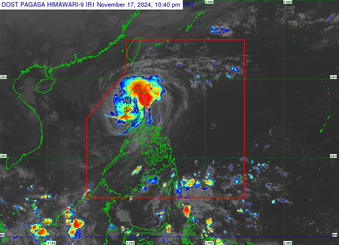
Typhoon “Pepito” (international name: Man-yi) has weakened further after crossing the landmass of Luzon, said the Philippine Atmospheric, Geophysical and Astronomical Services Administration (PAGASA) on Sunday, Nov. 17.
It made two landfalls: first over Panganiban, Catanduanes at 9:20 p.m. on Saturday, Nov. 16, and then over Dipaculao, Aurora at 3:20 p.m. on Sunday.
In its 11 p.m. bulletin on Sunday, PAGASA said the center of the typhoon is now located over the coastal waters of La Union and Pangasinan, around 25 kilometers southwest of Bacnotan, La Union.
Pepito has maximum sustained winds of 155 kilometers per hour (kph) near its center and gusts reaching 255 kph. Previously, it had maximum sustained winds of 165 kph and gusts up to 265 kph.
However, Signal No. 4 remains in effect over the southern portion of Ilocos Sur (Alilem, Sugpon, Suyo, Santa Cruz, Tagudin, City of Candon, Santa Lucia, Salcedo, Galimuyod, Cervantes, Sigay), La Union, northern portion of Pangasinan (Sison, Tayug, Binalonan, San Manuel, Asingan, San Quintin, Santa Maria, Natividad, San Nicolas, Balungao, Pozorrubio, Laoac, San Jacinto, San Fabian, Manaoag, City of Urdaneta, Rosales, Umingan, Mangaldan, Mapandan, Villasis, Santo Tomas, Dagupan City, Anda, Bolinao, Bani, City of Alaminos, Lingayen, Binmaley, Sual, Labrador), Benguet, southwestern portion of Ifugao (Tinoc, Asipulo), western portion of Nueva Vizcaya (Bayombong, Ambaguio, Villaverde, Kayapa, Santa Fe, Aritao, Bambang, Solano), and northern portion of Nueva Ecija (Lupao, Carranglan). Significant to severe impacts from typhoon-force winds may be felt in these areas.
Signal No. 3 remains raised over the rest of Ilocos Sur, the rest of Pangasinan, southern portion of Abra (Tubo, Luba, Pilar, Villaviciosa, San Isidro, Pidigan, Langiden, San Quintin, Bangued, Manabo, Boliney, Peñarrubia, Bucloc, Sallapadan, Bucay), southern portion of Kalinga (Pasil, Tanudan, Lubuagan, Tinglayan), Mountain Province, the rest of Ifugao, southern portion of Isabela (Ramon, City of Santiago, Cordon, San Agustin, Jones, Echague, San Isidro, San Mateo, Alicia), Quirino, the rest of Nueva Vizcaya, northern portion of Tarlac (Paniqui, La Paz, Moncada, City of Tarlac, Gerona, Pura, San Clemente, Santa Ignacia, Victoria, Camiling, Ramos, San Manuel, Anao), central portion of Nueva Ecija (Talavera, Santo Domingo, Zaragoza, Guimba, Aliaga, Cabanatuan City, Quezon, Santa Rosa, Nampicuan, Licab, Palayan City, General Mamerto Natividad, Laur, San Jose City, Pantabangan, Science City of Muñoz, Rizal, Llanera, Bongabon, Talugtug, Cuyapo), and central portion of Aurora (Maria Aurora, Dipaculao, Baler, Dinalungan). These areas may experience “moderate to significant impacts” from storm-force winds.
Areas under Signal No. 2 are Ilocos Norte, the southern portion of Apayao (Conner, Kabugao), the rest of Abra, the rest of Kalinga, southwestern portion of Cagayan (Enrile, Tuao, Solana, Tuguegarao City, Piat, Rizal), western, central, and southern portions of Isabela (Santo Tomas, Aurora, Santa Maria, Quezon, San Mariano, Naguilian, Dinapigue, Roxas, San Guillermo, Luna, Delfin Albano, City of Cauayan, Ilagan City, Angadanan, Benito Soliven, Tumauini, Cabagan, Reina Mercedes, San Manuel, Cabatuan, Quirino, Gamu, Mallig, Burgos), the rest of Aurora, Zambales, the rest of Tarlac, the rest of Nueva Ecija, Pampanga, and northern portion of Bulacan (San Ildefonso, San Miguel, Doña Remedios Trinidad, San Rafael, Baliuag, Pulilan, Calumpit). “Minor to moderate impacts” from gale-force winds are possible in these areas.
The rest of mainland Cagayan, the rest of Isabela, the rest of Apayao, Bataan, the rest of Bulacan, Metro Manila, Rizal, Cavite, Laguna, northern portion of Quezon (Infanta, Lucban, Sampaloc, Dolores, General Nakar, Real, Mauban, including Polillo Islands), and northern portion of Batangas (Calaca, Lian, Tuy, Balayan, Talisay, Agoncillo, Santo Tomas, Lemery, City of Tanauan, Mataasnakahoy, Balete, Nasugbu, San Nicolas, Laurel, Malvar) are under Signal No. 1. These areas may experience “minimal to minor impacts” from strong winds.
PAGASA warned that heavy to intense rainfall (100 to 200 millimeters) may persist in La Union, Pangasinan, Aurora, Quirino, Nueva Ecija, Benguet, Ifugao, Kalinga, Mountain Province, and Nueva Vizcaya. It said “numerous flooding events” are possible, especially in urbanized, low-lying, or river-adjacent areas. Landslides are also likely in areas with “moderate to high” susceptibility.
Meanwhile, moderate to heavy rainfall (50 to 100 millimeters) is expected in Bulacan, Cagayan, Apayao, Abra, Ilocos Sur, Pampanga, Isabela, Ilocos Norte, Tarlac, and Zambales, where localized flooding and landslides are possible.
PAGASA advised residents in affected areas to remain vigilant, as Pepito continues to pose a significant threat to lives, properties, and infrastructure.
Pepito is expected to continue its west-northwestward movement over the West Philippine Sea, weakening further due to an unfavorable environment, PAGASA said.
It is expected to exit the Philippine area of responsibility by Monday morning or noon, Nov. 18.