Catanduanes, portions of CamSur under Signal No. 5 as STY 'Pepito' nears landfall
PAGASA warns of 'potentially catastrophic and life-threatening situation' for Northeastern Bicol
Ahead of its expected landfall late Saturday, Nov. 16, or early tomorrow in Catanduanes, the Philippine Atmospheric, Geophysical, and Astronomical Services Administration (PAGASA) said Super Typhoon Pepito (international name: Man-yi) continues to pose a “potentially catastrophic and life-threatening situation” for the northeastern Bicol region.

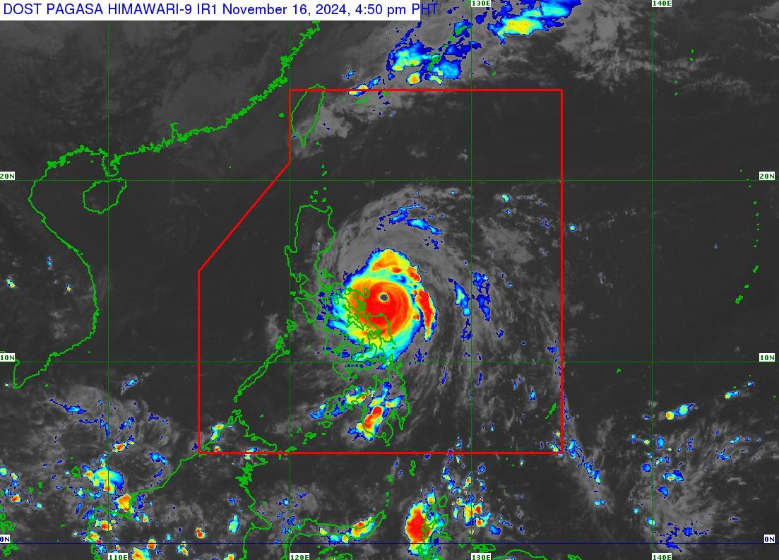
In its 5 p.m. bulletin, PAGASA reported that the center of the eye of STY Pepito was estimated to be 120 km east of Virac, Catanduanes, with maximum sustained winds of 195 km/h near the center, gustiness of up to 240 km/h, and a central pressure of 920 hPa.
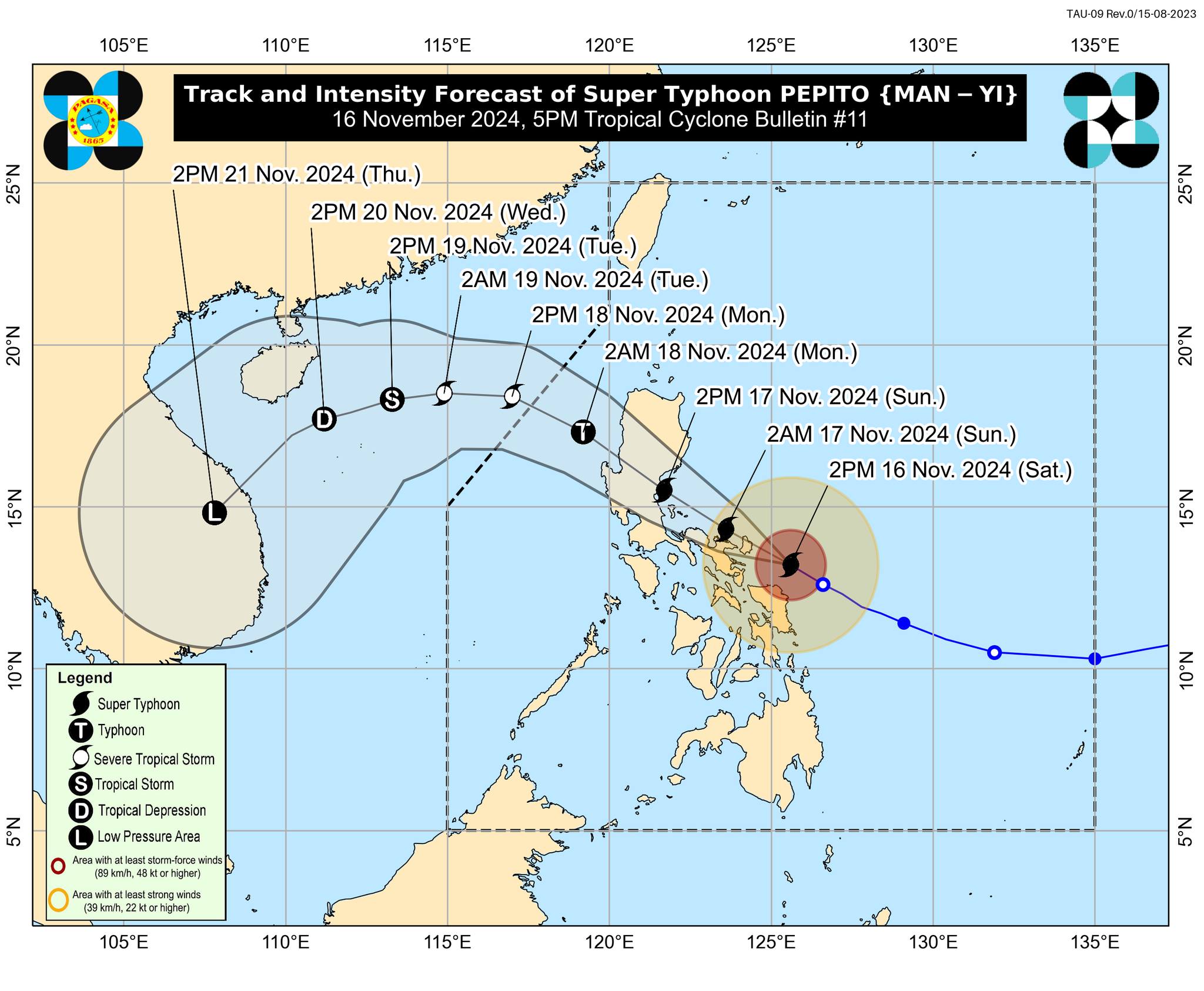
PAGASA also mentioned that “Pepito” is moving west-northwestward at 20 km/h.
Strong typhoon-force winds, extending up to 300 km from the center, are also expected during the occurrence of STY Pepito, according to PAGASA.
Expected landfall
Based on its track and intensity outlook, PAGASA said “Pepito” is forecast to move generally west-northwestward over the next three days before turning westward to west-southwestward from the afternoon of Nov. 18 to the early morning of Nov. 21.
“According to the track forecast, Pepito is more likely to make landfall in the vicinity of Catanduanes tonight or early tomorrow morning (Nov. 17),” PAGASA said.

PAGASA also noted that a landfall scenario over the eastern coast of Camarines Sur or Albay during the same time frame—if it moves slightly south of the forecast track—or along the eastern coast of Quezon or Aurora (tomorrow afternoon or evening) remains possible if it moves slightly north of the forecast track.
Regardless of the landfall point, PAGASA said “Pepito” will move generally west-northwestward over the weekend and pass over or near the localities of the Bicol Region, Central Luzon, Quezon, and the southern portions of the Ilocos Region and the Cordillera Administrative Region before emerging over the West Philippine Sea in the evening of Nov. 17 or the early morning of Nov. 18.
PAGASA noted that STY Pepito will likely make landfall over Catanduanes as a super typhoon at or near peak intensity and as a super typhoon or typhoon over the Quezon-Aurora area.
“Significant weakening will occur during Pepito's passage over mainland Luzon tomorrow, but it will likely remain a typhoon until it reaches the West Philippine Sea,” PAGASA added.
Areas under Tropical Cyclone Wind Signals
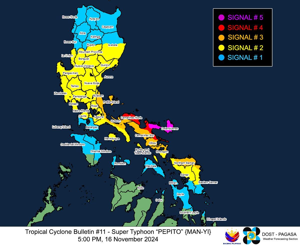
Typhoon-force winds are expected in Catanduanes and the northeastern portion of Camarines Sur (Caramoan, Garchitorena, Lagonoy, Presentacion), which have been placed under Tropical Cyclone Wind Signal (TCWS) No. 5.

The areas under TCWS No. 4 include Camarines Norte, the northern and southeastern portions of Camarines Sur (Siruma, Tinambac, Goa, San Jose, Tigaon, Sagñay, Calabanga), and the northeastern portion of Albay (City of Tabaco, Tiwi, Malinao, Malilipot, Bacacay, Rapu-Rapu).
The Polillo Islands, the northern and eastern portions of mainland Quezon (Calauag, Guinayangan, Tagkawayan, Buenavista, Lopez, Quezon, Perez, Alabat, Gumaca, Plaridel, Atimonan, Mauban, Real, General Nakar, Infanta), the rest of Camarines Sur, the rest of Albay, and the northern portion of Sorsogon (Prieto Diaz, City of Sorsogon, Gubat, Barcelona, Castilla, Casiguran, Pilar, Donsol) in Luzon have been placed under Signal No. 3.
Likewise, Signal No. 3 has been raised in the eastern and central portions of Northern Samar (Palapag, Laoang, Mapanas, Gamay, Lapinig, Catubig, Pambujan, Las Navas, Biri, Bobon, Catarman, Mondragon, San Roque, Silvino Lobos, Lope de Vega, San Jose) and the northern portion of Eastern Samar (San Policarpo, Arteche, Oras, Jipapad).
TCWS No. 2 has been hoisted in the southern portion of Isabela (Calauag, Guinayangan, Tagkawayan, Buenavista, Lopez, Quezon, Perez, Alabat, Gumaca, Plaridel, Atimonan, Mauban, Real, General Nakar, Infanta), Quirino, Nueva Vizcaya, Ifugao, Benguet, La Union, Pangasinan, Aurora, Nueva Ecija, Bulacan, Tarlac, Pampanga, Zambales, Bataan, Metro Manila, Cavite, Rizal, the rest of Quezon, Laguna, Marinduque, the rest of Sorsogon, Burias Island, and Ticao Island.
The central portion of Eastern Samar (Dolores, Maslog, Can-Avid, Taft, Sulat, San Julian, City of Borongan), the northern portion of Samar (Matuguinao, Calbayog City, Santa Margarita, San Jorge, San Jose de Buan, Tarangnan, Motiong, Gandara, Jiabong, City of Catbalogan, Paranas, Hinabangan, San Sebastian, Pagsanghan), and the rest of Northern Samar were also placed under Signal No. 2.
TCWS No. 1 was hoisted in mainland Cagayan, the rest of Isabela, Apayao, Kalinga, Abra, Mountain Province, Ifugao, Benguet, Ilocos Norte, Ilocos Sur, La Union, the rest of Pangasinan, the rest of Zambales, Batangas, the northern portion of Occidental Mindoro (Sablayan, Santa Cruz, Mamburao, Abra de Ilog, Paluan) including Lubang Islands, the northern portion of Oriental Mindoro (Puerto Galera, San Teodoro, Naujan, Baco, Victoria, Socorro, Pinamalayan, Bansud, Gloria, Pola, City of Calapan, Bongabong, Roxas, Mansalay), Romblon, and the rest of Masbate.
The rest of Eastern Samar, the rest of Samar, Biliran, the northern and central portions of Leyte (Tunga, Pastrana, San Miguel, Matag-Ob, Tolosa, Palo, Calubian, Leyte, Mayorga, Julita, Carigara, Babatngon, Dagami, Jaro, San Isidro, Santa Fe, Albuera, Villaba, La Paz, Palompon, Macarthur, Tabontabon, Tanauan, Merida, Ormoc City, Isabel, Dulag, Capoocan, Alangalang, Burauen, Tabango, Tacloban City, Kananga, Barugo, Abuyog, Javier, City of Baybay, Mahaplag), the northeastern portion of Southern Leyte (Silago), the northernmost portion of Cebu (Daanbantayan, Medellin) including Bantayan Islands, and the northernmost portion of Iloilo (Carles) and the northern portion of Dinagat Islands (Loreto, Tubajon) in Mindanao are under Signal No. 1.
Take necessary measures
With these developments, PAGASA advised the public and disaster risk reduction and management offices concerned to take all necessary measures to protect life and property.
PAGASA has issued heavy rainfall outlooks and storm surge warnings for the areas affected by “Pepito.”
READ:
https://mb.com.ph/2024/11/16/high-storm-surge-risk-due-to-pepito
“Persons living in areas identified as highly or very highly susceptible to these hazards are advised to follow evacuation and other instructions from local officials,” PAGASA said.
RELATED STORY:
https://mb.com.ph/2024/11/16/catastrophic-threat-looms-as-pepito-intensifies