PAGASA: 'Pepito' now a super typhoon
Signal No. 4 up in Catanduanes, northeastern portion of Camarines Sur
“Pepito” (international name: Man-yi) continued to threaten the Bicol Region as it intensified into a super typhoon.

In a tropical cyclone bulletin issued at 11 a.m. on Saturday, Nov. 16, the Philippine Atmospheric, Geophysical and Astronomical Services Administration (PAGASA) warned that “Pepito is approaching its peak intensity.”
Citing radar imagery, PAGASA noted that the intensity of “Pepito” may begin to stabilize or slightly decrease in the coming hours. However, it noted that if the ongoing eyewall replacement process is completed before its passage over Catanduanes, the super typhoon could resume intensifying.
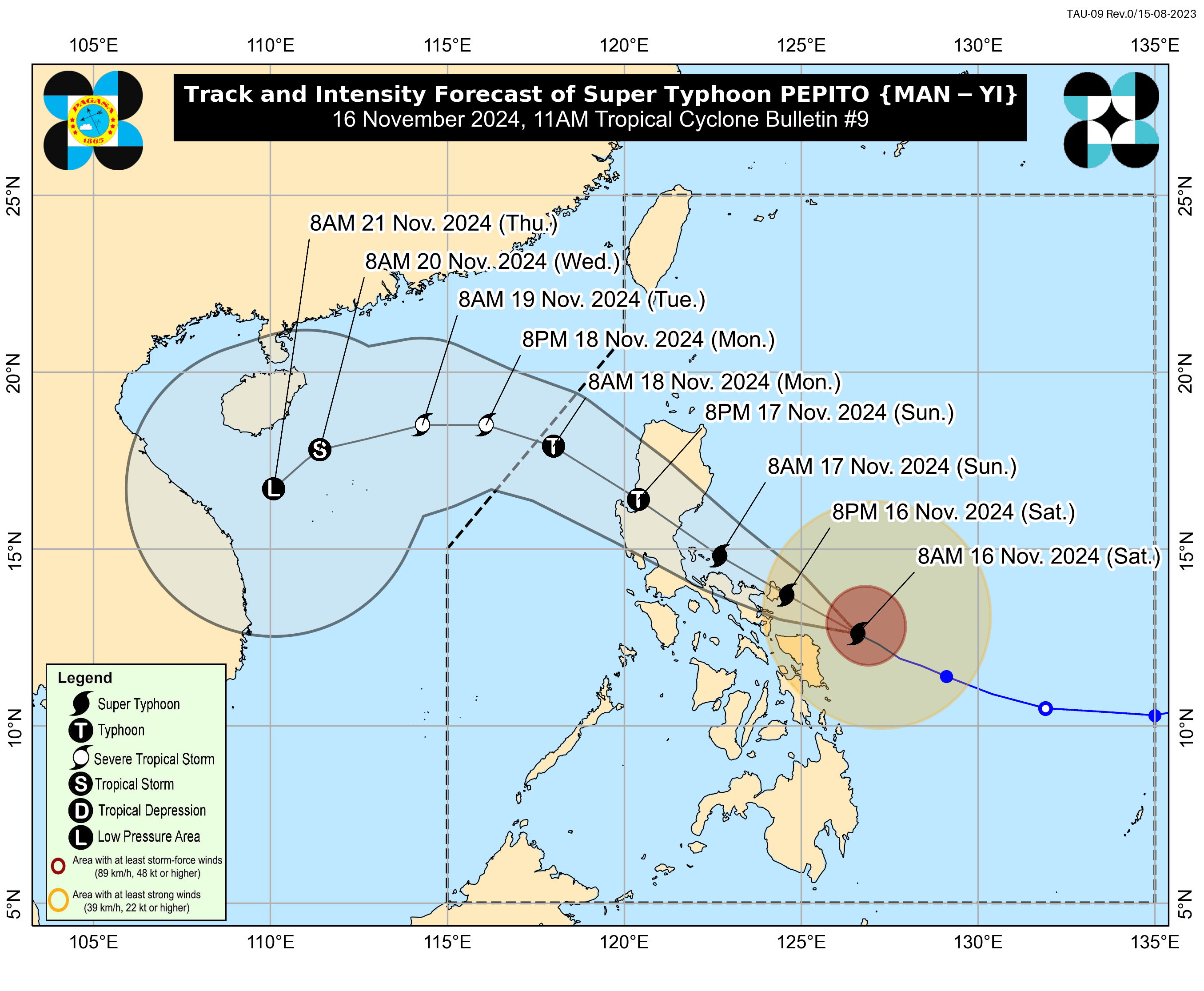
As of 10 a.m., PAGASA reported that the center of the eye of Super Typhoon “Pepito” was estimated at 185 km east of Catarman, Northern Samar, or 250 km east of Juban, Sorsogon.
“Pepito” is moving west-northwestward at 25 km/h with maximum sustained winds of 185 km/h near the center, gustiness of up to 230 km/h, and a central pressure of 925 hPa.
PAGASA said “Pepito” will likely make landfall over Catanduanes as a super typhoon at or near peak intensity and as a super typhoon or typhoon over the Quezon-Aurora area.
A “significant weakening” is expected during the typhoon’s passage over mainland Luzon on Nov. 17, but it will likely remain a typhoon as it moves into the West Philippine Sea.
Beware of severe winds
PAGASA stated that Tropical Cyclone Wind Signal (TCWS) No. 5 may be raised during the occurrence of “Pepito.”
Typhoon-force winds are expected in Catanduanes and the northeastern portion of Camarines Sur (Garchitorena, Presentacion, Caramoan, Lagonoy, San Jose), which have been placed under Signal No. 4. PAGASA warned that these areas are “very likely” to be directly hit by the eye of the typhoon.
“As the eye of the typhoon approaches, the weather will continuously worsen, with winds increasing to their strongest, generally coming from the north,” it added.
Signal No. 3 was hoisted in the eastern portion of Camarines Norte (Vinzons, Talisay, Mercedes, Daet, Basud, San Vicente, San Lorenzo Ruiz), the northern and southeastern portion of Camarines Sur (Sagñay, Tigaon, Goa, Tinambac, Siruma, Buhi, Ocampo, Iriga City, Sipocot, Pili, Cabusao, Calabanga, Bombon, Magarao, Canaman, Naga City, Camaligan), the eastern portion of Albay (City of Tabaco, Malilipot, Tiwi, Malinao, Santo Domingo, Manito, Legazpi City, Bacacay, Rapu-Rapu), and the northeastern portion of Sorsogon (Prieto Diaz, City of Sorsogon, Gubat).
The eastern portion of Northern Samar (Palapag, Laoang, Mapanas, Gamay, Lapinig, Catubig, Pambujan) and the northern portion of Eastern Samar (San Policarpo, Arteche, Oras, Jipapad) were also placed under Signal No. 3.
The southeastern portion of Isabela (Dinapigue), Aurora, Quezon, the eastern portion of Rizal (Tanay, Pililla, Jala-Jala), Laguna, the rest of Camarines Norte, the rest of Camarines Sur, the rest of Albay, the rest of Sorsogon, Burias Island, and Ticao Island and the central portion of Eastern Samar (Dolores, Maslog, Can-Avid, Taft, Sulat, San Julian, City of Borongan), the northern portion of Samar (Matuguinao, Calbayog City, Santa Margarita, San Jorge, San Jose de Buan, Tarangnan, Motiong, Gandara, Jiabong, City of Catbalogan, Paranas, Hinabangan, San Sebastian, Pagsanghan), and the rest of Northern Samar were placed under Signal No. 2.
Meanwhile, Signal No. 1 was raised in mainland Cagayan, the rest of Isabela, Quirino, Nueva Vizcaya, Apayao, Kalinga, Abra, Mountain Province, Ifugao, Benguet, Ilocos Norte, Ilocos Sur, La Union, and Pangasinan, Nueva Ecija, Bulacan, Tarlac, Pampanga, Zambales, Bataan, Metro Manila, the rest of Rizal, Cavite, Batangas, Marinduque, the northern portion of Oriental Mindoro (Puerto Galera, San Teodoro, Naujan, Baco, Victoria, Socorro, Pinamalayan, Bansud, Gloria, Pola, City of Calapan), Romblon, and the rest of Masbate.
Areas in the Visayas including the rest of Eastern Samar, the rest of Samar, Biliran, the northern and central portions of Leyte (Tunga, Pastrana, San Miguel, Matag-Ob, Tolosa, Palo, Calubian, Leyte, Mayorga, Julita, Carigara, Babatngon, Dagami, Jaro, San Isidro, Santa Fe, Albuera, Villaba, La Paz, Palompon, Macarthur, Tabontabon, Tanauan, Merida, Ormoc City, Isabel, Dulag, Capoocan, Alangalang, Burauen, Tabango, Tacloban City, Kananga, Barugo, Abuyog, Javier, City of Baybay, Mahaplag), the northeastern portion of Southern Leyte (Silago), the northernmost portion of Cebu (Daanbantayan, Medellin) including Bantayan Islands, and the northernmost portion of Iloilo (Carles) and the northern portion of Dinagat Islands (Loreto, Tubajon) in Mindanao were also placed under Signal No. 1.
Storm surge warning
PAGASA maintained that there is a “high risk of life-threatening storm surge” with peak heights exceeding 3.0 m within the next 48 hours in low-lying or exposed coastal areas including Ilocos Region (western coast), Isabela, Central Luzon, Metro Manila, CALABARZON, Marinduque, Bicol Region, Northern Samar, Samar, Eastern Samar, Biliran, and Leyte (northeastern coast).
A gale warning was also issued for the eastern and southern seaboard of Southern Luzon and the eastern seaboard of Visayas.
Projected track
“Pepito” is forecast to move generally west-northwestward for the next three days before turning west to west-southwestward from Monday afternoon, Nov. 18, to Thursday early morning, Nov. 21.
The typhoon is likely to make landfall over Catanduanes tonight or early tomorrow morning.
However, PAGASA cautioned that if the track shifts slightly south, landfall could occur over the eastern coast of Camarines Sur or Albay during the same time frame.
Conversely, a northward shift could result in landfall along the eastern coast of Quezon or Aurora tomorrow afternoon or evening.
“Pepito” is expected to exit the Philippine Area of Responsibility (PAR) by Nov. 18.