Muntinlupa LGU preparing for preemptive evacuation for super typhoon #PepitoPH
The Muntinlupa City government is preparing for a preemptive evacuation of residents in flood-prone barangays due to super typhoon "Pepito" ("Man-yi").
Metro Manila is now under Tropical Cyclone Wind Signal (CWS) No. 2, according to the Philippine Atmospheric, Geophysical, and Astronomical Services Administration (PAGASA) in a bulletin issued at 2 p.m. on Nov. 16.
Mayor Ruffy Biazon said the Muntinlupa Emergency Operations Center is now under blue alert status.
Biazon called for a second pre-disaster risk assessment meeting on Nov. 16 for the plans of the city government for the possible onslaught of the super typhoon.


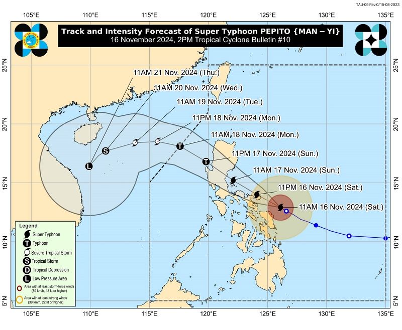
The track of super typhoon "Pepito" (PAGASA)

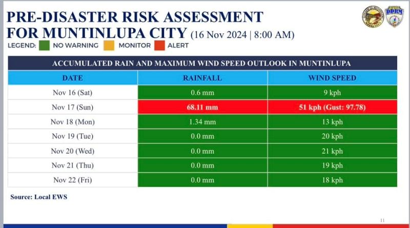
Muntinlupa will experience a rainfall of 68.11 mm on Nov. 17 (Photo from Mayor Biazon's Facebook account)
Citing data, Biazon said effects of the typhoon will be felt on Nov. 17, Sunday, and is expected that the strongest rains and winds will be felt at 2 p.m.
“May posibilidad din ng Signal No. 2 to 4 sa Muntinlupa (There is a possibility that Muntinlupa will be under Signal No. 2 to 4),” he posted on Facebook.
Schools will be used as evacuation centers for families that will be affected by the super typhoon.
He added that goods, teams and equipment have been prepositioned in barangays and offices of the city government.
Medical personnel from the City Health Office will be on standby and medical supplies and monitoring teams are ready.
The emergency room and outpatient department at the Ospital ng Muntinlupa are prepared.
Service vehicles and resources of the city government have also been prepositioned.
“Handang rumesponde at magbigay ng tulong kung kinakailangan ang ating city government (The city government is ready to respond and provide help if needed),” said Biazon.
Here is PAGASA's Tropical Cyclone Bulletin No. 10 for super typhoon "Pepito":
TROPICAL CYCLONE BULLETIN NR. 10
Super Typhoon #PepitoPH (MAN-YI)
Issued at 2:00 PM, 16 November 2024
Valid for broadcast until the next bulletin at 5:00 PM today.
POTENTIALLY CATASTROPHIC AND LIFE-THREATENING SITUATION LOOMS FOR NORTHEASTERN BICOL REGION AS SUPER TYPHOON “PEPITO” FURTHER INTENSIFIES
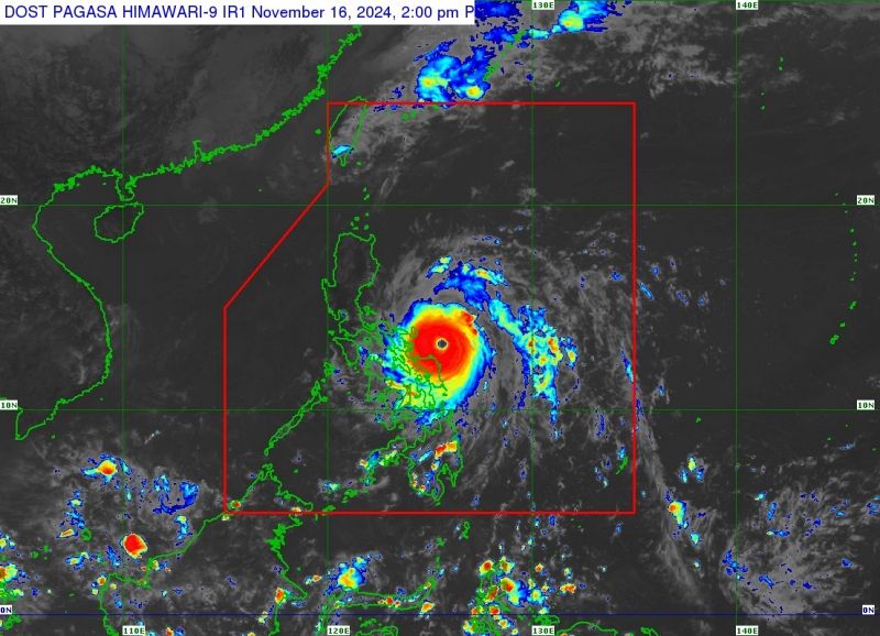
Location of Center (1:00 PM): The center of the eye of Super Typhoon PEPITO was estimated based on all available data including from Guiuan, Laoang, Masbate, and Daet Weather Radars at 200 km East of Juban, Sorsogon or 180 km East Southeast of Virac, Catanduanes (13.1 °N, 125.8°E).
Intensity: Maximum sustained winds of 195 km/h near the center, gustiness of up to 240 km/h, and central pressure of 920 hPa
Present Movement: West northwestward at 20 km/h
Extent of Tropical Cyclone Winds: Strong to typhoon-force winds extend outwards up to 300 km from the center
TROPICAL CYCLONE WIND SIGNALS (TCWS) IN EFFECT
TCWS No. 5
Wind threat: Typhoon-force wind
Luzon
Catanduanes
Warning lead time: 12 hours
Range of wind speeds: 185 km/h or higher (Beaufort 12)
Potential impacts of winds: Extreme threat to life and property
TCWS No. 4
Wind threat: Typhoon-force winds
Luzon
The northeastern portion of Camarines Sur (Garchitorena, Caramoan, Presentacion, Siruma, Tinambac, Goa, Lagonoy, San Jose, Tigaon, Sagñay) and the northeastern portion of Albay (City of Tabaco, Tiwi, Malinao, Malilipot, Bacacay, Rapu-Rapu)
Warning lead time: 12 hours
Range of wind speeds: 118 to 184 km/h (Beaufort 12)
Potential impacts of winds: Significant to severe threat to life and property
TCWS No. 3
Wind threat: Storm-force winds
Luzon
Polillo Islands, the southeastern portion of mainland Quezon (Calauag, Guinayangan, Tagkawayan, Buenavista), Camarines Norte, the rest of Camarines Sur, the rest of Albay, and the northern portion of Sorsogon (Prieto Diaz, City of Sorsogon, Gubat, Barcelona, Castilla, Casiguran, Pilar, Donsol)
Visayas
The eastern and central portions of Northern Samar (Palapag, Laoang, Mapanas, Gamay, Lapinig, Catubig, Pambujan, Las Navas, Biri, Bobon, Catarman, Mondragon, San Roque, Silvino Lobos, Lope de Vega, San Jose) and the northern portion of Eastern Samar (San Policarpo, Arteche, Oras, Jipapad) -
Warning lead time: 18 hours
Range of wind speeds: 89 to 117 km/h (Beaufort 10 to 11)
Potential impacts of winds: Moderate to significant threat to life and property
TCWS No. 2
Wind threat: Gale-force winds
Luzon
The southern portion of Isabela (Dinapigue, Cordon, Ramon, Alicia, City of Cauayan, Angadanan, City of Santiago, San Isidro, Echague, Jones, San Agustin, San Guillermo, San Mariano, Benito Soliven, Naguilian, Palanan), Quirino, Nueva Vizcaya, the eastern portion of Pangasinan (San Nicolas, Umingan, Natividad, San Quintin, Tayug, Santa Maria, Rosales, Balungao, San Manuel, Villasis, Malasiqui, Bautista, Mapandan, Binalonan, Alcala, Asingan, Santo Tomas, City of Urdaneta, Laoac, Manaoag, Bayambang, Santa Barbara), Aurora, Nueva Ecija, Bulacan, Tarlac, Pampanga, the southern portion of Zambales (Botolan, Cabangan, San Marcelino, San Felipe, San Narciso, San Antonio, Castillejos, Subic, Olongapo City), Bataan, Metro Manila, Rizal, the rest of Quezon, Laguna, Cavite, Marinduque, the rest of Sorsogon, Burias Island, and Ticao Island
Visayas
The central portion of Eastern Samar (Dolores, Maslog, Can-Avid, Taft, Sulat, San Julian, City of Borongan), the northern portion of Samar (Matuguinao, Calbayog City, Santa Margarita, San Jorge, San Jose de Buan, Tarangnan, Motiong, Gandara, Jiabong, City of Catbalogan, Paranas, Hinabangan, San Sebastian, Pagsanghan), and the rest of Northern Samar -
Warning lead time: 24 hours
Range of wind speeds: 62 to 88 km/h (Beaufort 8 to 9)
Potential impacts of winds: Minor to moderate threat to life and property
TCWS No. 1
Wind threat: Strong winds
Luzon
Mainland Cagayan, the rest of Isabela, Apayao, Kalinga, Abra, Mountain Province, Ifugao, Benguet, Ilocos Norte, Ilocos Sur, La Union, the rest of Pangasinan, the rest of Zambales, Batangas, the northern portion of Occidental Mindoro (Sablayan, Santa Cruz, Mamburao, Abra de Ilog, Paluan) including Lubang Islands, the northern portion of Oriental Mindoro (Puerto Galera, San Teodoro, Naujan, Baco, Victoria, Socorro, Pinamalayan, Bansud, Gloria, Pola, City of Calapan, Bongabong, Roxas, Mansalay), Romblon, and the rest of Masbate
Visayas
The rest of Eastern Samar, the rest of Samar, Biliran, the northern and central portions of Leyte (Tunga, Pastrana, San Miguel, Matag-Ob, Tolosa, Palo, Calubian, Leyte, Mayorga, Julita, Carigara, Babatngon, Dagami, Jaro, San Isidro, Santa Fe, Albuera, Villaba, La Paz, Palompon, Macarthur, Tabontabon, Tanauan, Merida, Ormoc City, Isabel, Dulag, Capoocan, Alangalang, Burauen, Tabango, Tacloban City, Kananga, Barugo, Abuyog, Javier, City of Baybay, Mahaplag), the northeastern portion of Southern Leyte (Silago), the northernmost portion of Cebu (Daanbantayan, Medellin) including Bantayan Islands, and the northernmost portion of Iloilo (Carles)
Mindanao
The northern portion of Dinagat Islands (Loreto, Tubajon)
Warning lead time: 36 hours
Range of wind speeds: 39 to 61 km/h (Beaufort 6 to 7)
Potential impacts of winds: Minimal to minor threat to life and property
OTHER HAZARDS AFFECTING LAND AREAS
Heavy Rainfall Outlook
Refer to Weather Advisory No. 44 issued at 2:00 PM today for the three-day heavy rainfall outlook associated with “PEPITO”.
Severe Winds
The wind signals warn the public of the general wind threat over an area due to the tropical cyclone. Local winds may be slightly stronger/enhanced in coastal and upland/mountainous areas exposed to winds. Winds are less strong in areas sheltered from the prevailing wind direction.
• Extreme impacts from typhoon-force winds are possible within any of the areas under Wind Signal No. 5.
• Significant to severe impacts from typhoon-force winds are possible within any of the areas under Wind Signal No. 4.
• Moderate to significant impacts from storm-force winds are possible within any of the areas under Wind Signal No. 3.
• Minor to moderate impacts from gale-force winds are possible within any of the areas under Wind Signal No. 2.
• Minimal to minor impacts from strong winds are possible within any of the areas under Wind Signal No. 1.
Coastal Inundation
There is a high risk of life-threatening storm surge with peak heights exceeding 3.0 m in the next 48 hours over the low-lying or exposed coastal localities of Ilocos Region (western coast), Isabela, Central Luzon, Metro Manila, CALABARZON, Marinduque, Bicol Region, Northern Samar, Samar, Eastern Samar, and Biliran. Refer to Storm Surge Warning No. 7 issued at 2:00 PM today for the details.
HAZARDS AFFECTING COASTAL WATERS
A Gale Warning is hoisted over the eastern and southern seaboards of Southern Luzon and the eastern seabooad of Visayas. Refer to Gale Warning No. 10 issued at 5:00 AM today for the details.
24-Hour Sea Condition Outlook
Up to very rough, high, or very high seas over the following coastal waters:
• Up to 14.0 m: The seaboard of Catanduanes.
• Up to 12.0 m: The northern seaboard of Camarines Sur.
• Up to 9.0 m: The northern and eastern seaboards of Northern Samar; the seaboard of Camarines Norte.
• Up to 7.0 m: The eastern seaboards of Albay, Sorsogon, and Eastern Samar.
• Up to 5.5 m: The remaining seaboards of Camarines Sur.
• Up to 4.5 m: The northern and eastern seaboards of Polillo Islands; the seaboards of Aurora; the remaining seaboards of Albay, Sorsogon, and Northern Samar; the seaboards of Burias and Ticao Islands.
• Sea travel is risky for all types or tonnage of vessels. All mariners must remain in port or, if underway, seek shelter or safe harbor as soon as possible until winds and waves subside.
Up to rough seas over the following coastal waters:
• Up to 4.0 m: The seaboards of Dinagat Islands and northern Quezon.
• Up to 3.5 m: The seaboards of Isabela and Surigao del Norte including Siargao and Bucas Grande Islands; the remaining seaboards of Polillo Islands and Quezon, Bicol Region, and Eastern Visayas
• Up to 3.0 m: The eastern seaboards of Cagayan and Babuyan Islands; the seaboard of Surigao del Sur; the seaboards of Marinduque, Romblon, and northern Cebu
• Mariners of small seacrafts, including all types of motorbancas, are advised not to venture out to sea under these conditions, especially if inexperienced or operating ill-equipped vessels.
Up to moderate seas over the following coastal waters:
• Up to 2.5 m: The seaboards of Batanes and Davao Oriental
• Up to 2.0 m: The seaboards of Oriental Mindoro, Aklan, Capiz, Davao del Sur, and Ilocos Region.
• Mariners of motorbancas and similarly-sized vessels are advised to take precautionary measures while venturing out to sea and, if possible, avoid navigation under these conditions.
TRACK AND INTENSITY OUTLOOK
• PEPITO is forecast to move generally west northwestward within the next three days before turning generally westward to west southwestward from Monday (18 November) afternoon to Thursday (21 November) early morning. On the track forecast, PEPITO is more likely to make landfall in the vicinity of Catanduanes tonight or tomorrow (17 November) early morning. However, considering the limits of the forecast confidence cone, a landfall scenario over the eastern coast of Camarines Sur or Albay during the same time frame (if it moves slightly south of forecast track), or along the eastern coast of Quezon or Aurora tomorrow afternoon or evening remains (if it moves slightly north of forecast track) not ruled out. PEPITO is expected to exit the Philippine Area of Responsibility (PAR) on Monday.
• Regardless of the landfall point, the PEPITO will move generally west northwestward over the weekend and pass over or near the localities of Bicol Region, Central Luzon, Quezon, and the southern portions of Ilocos Region and Cordillera Administrative Region before emerging over the West Philippine Sea tomorrow evening or Monday morning.
• It must be emphasized that heavy rainfall, severe winds, and storm surge may still be experienced in localities outside the landfall point and the forecast confidence cone. Refer to “Other Hazards affecting Land Areas” for more details. Furthermore, the track may still shift within the limit of the forecast confidence cone.
• PEPITO is approaching its peak intensity. With radar imagery showing signs of eyewall replacement, the intensity of PEPITO may begin to maintain or slightly decrease in the next coming hours. However, if the eyewall replacement finishes prior to its passage over Catanduanes, the super typhoon will resume intensifying as forecasted. Nevertheless, PEPITO will likely make landfall over Catanduanes as a super typhoon at or near peak intensity, and as a super typhoon or typhoon over the Quezon-Aurora area. Significant weakening will occur during the passage of PEPITO over mainland Luzon tomorrow, but it will likely remains as a typhoon until it reaches the West Philippine Sea.
Considering these developments, the public and disaster risk reduction and management offices concerned are advised to take all necessary measures to protect life and property. Persons living in areas identified to be highly or very highly susceptible to these hazards are advised to follow evacuation and other instructions from local officials. For heavy rainfall warnings, thunderstorm/rainfall advisories, and other severe weather information specific to your area, please monitor products issued by your local PAGASA Regional Services Division.
The next tropical cyclone bulletin will be issued at 5:00 PM today.