ADVERTISEMENT

'Pepito' intensifies into typhoon; 'Ofel' weakens into severe tropical storm

Published Nov 15, 2024 05:19 am
IMG_4584.jpeg
PAGASA

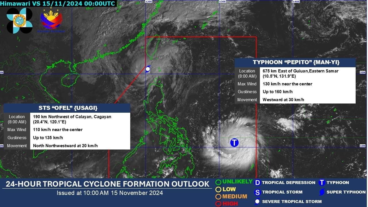
The Philippine Atmospheric, Geophysical and Astronomical Services Administration (PAGASA) said on Friday, Nov. 15 that Severe Tropical Storm “Pepito” (international name: Man-yi) has intensified into a typhoon, while Typhoon “Ofel” (international name: Usagi) has weakened into a severe tropical storm on Friday, Nov. 15.

In its 11 a.m. bulletin, PAGASA said Typhoon Pepito is undergoing rapid intensification, and now has maximum sustained winds of 130 kilometers per hour (kph) near its center and gusts reaching 160 kph.

Due to favorable environmental conditions, Pepito is likely to strengthen into a super typhoon before making landfall over Catanduanes between Saturday evening, Nov. 16, and Sunday morning, Nov. 17.

At 10 a.m. on Friday, the center of the eye of the typhoon was located 630 kilometers east of Guiuan, Eastern Samar.

Strong winds

In preparation for strong winds, PAGASA has raised Signal No. 2 over the eastern portion of Northern Samar (Mapanas, Gamay, Palapag, Lapinig) and northern portion of Eastern Samar (Arteche, Oras, San Policarpo, Dolores, Jipapad, Maslog). Gale-force winds could cause “minor to moderate impacts” in areas under Signal No. 2.

Signal No. 1 is also in effect over the southeastern portion of Quezon, Camarines Norte, Camarines Sur, Catanduanes, Albay, Sorsogon, Masbate, the rest of Northern Samar, the rest of Eastern Samar, Samar, and Biliran. There are “minimal to minor impacts” from strong winds in areas under Signal No. 1.

The highest wind warning that may be issued is Signal No. 5, which means that extreme impacts from typhoon-force winds are likely.

PAGASA also warned of “moderate to high risk” of life-threatening storm surge with peak heights reaching 3 meters above normal tide levels in the next 48 hours over the low-lying or exposed coastal localities of southeastern Quezon, Camarines Sur, Catanduanes, Albay, Sorsogon, northern Masbate including Burias and Ticao Islands, Northern Samar, Eastern Samar, Samar, and northern Biliran.

The landfall area remains uncertain, as PAGASA is still considering the possibility of a landfall along the eastern coast of Camarines Sur, Albay, or Sorsogon between Saturday evening and Sunday morning, or over the eastern coast of Northern Samar on Saturday afternoon or evening, or the eastern coasts of Quezon or Aurora on Sunday afternoon or evening.

After landfall, Senior Weather Specialist Glaiza Escullar said Pepito will move generally west-northwestward over Eastern Visayas, Bicol Region, Calabarzon, Mimaropa, Central Luzon, and parts of Northern Luzon, before emerging over the West Philippine Sea on Sunday evening or Monday, Nov. 18.

Rainfall outlook

From Saturday noon to Sunday noon, Catanduanes, Albay, Sorsogon, and Northern Samar are expected to experience intense to torrential rainfall (over 200 millimeters), which may lead to widespread flooding and landslides.

Heavy to intense rainfall (100 to 200 millimeters) may affect Eastern Samar, Camarines Sur, and Camarines Norte, where “numerous flooding events” are likely, especially in urbanized and low-lying areas or near rivers. Likewise, landslides are possible in areas with “moderate to high” susceptibility.

Moderate to heavy rainfall (50 to 100 millimeters) is likely in Masbate, Leyte, Quezon, Samar, and Biliran, where localized flooding and landslides are possible.

As Pepito moves over Luzon from Sunday noon to Monday noon, more areas are expected to experience intense to torrential rainfall, including Catanduanes, Quezon, Aurora, Camarines Norte, and Camarines Sur.

Heavy to intense rains may also affect Metro Manila, Northern Samar, Albay, Sorsogon, Marinduque, Cavite, Laguna, Rizal, Bulacan, and Nueva Ecija.

Bataan, Zambales, Tarlac, Batangas, Pampanga, Masbate, Romblon, Eastern Samar, Samar, Oriental Mindoro, Pangasinan, Nueva Vizcaya, and Quirino may experience moderate to heavy rains.

‘Ofel’ fizzles

Meanwhile, Ofel has continued to weaken as it traverses the Luzon Strait and has been downgraded to a severe tropical storm.

Ofel now has maximum sustained winds of 100 kph near the center and gusts reaching 135 kph. It is expected to further weaken into a remnant low.

As of 10 a.m., the center of Ofel was located 215 kilometers northwest of Calayan, Cagayan.

Signal No. 2 remains raised over Batanes, while Signal No. 1 is in effect over the northern portion of Cagayan (Pamplona, Claveria, Abulug, Sanchez-Mira, Santa Praxedes, Ballesteros), Babuyan Islands, northern Apayao (Luna, Santa Marcela, Calanasan), and northern portion of Ilocos Norte (Pagudpud, Adams, Bangui, Dumalneg, Burgos, Pasuquin, Vintar, Bacarra, Piddig, Carasi).

Related Tags

PAGASA Typhoon Ofel Usagi Man-yi Typhoon Pepito
ADVERTISEMENT
.most-popular .layout-ratio{ padding-bottom: 79.13%; } @media (min-width: 768px) and (max-width: 1024px) { .widget-title { font-size: 15px !important; } }

{{ articles_filter_1561_widget.title }}

.most-popular .layout-ratio{ padding-bottom: 79.13%; } @media (min-width: 768px) and (max-width: 1024px) { .widget-title { font-size: 15px !important; } }

{{ articles_filter_1562_widget.title }}

.most-popular .layout-ratio{ padding-bottom: 79.13%; } @media (min-width: 768px) and (max-width: 1024px) { .widget-title { font-size: 15px !important; } }

{{ articles_filter_1563_widget.title }}

{{ articles_filter_1564_widget.title }}

.mb-article-details { position: relative; } .mb-article-details .article-body-preview, .mb-article-details .article-body-summary{ font-size: 17px; line-height: 30px; font-family: "Libre Caslon Text", serif; color: #000; } .mb-article-details .article-body-preview iframe , .mb-article-details .article-body-summary iframe{ width: 100%; margin: auto; } .read-more-background { background: linear-gradient(180deg, color(display-p3 1.000 1.000 1.000 / 0) 13.75%, color(display-p3 1.000 1.000 1.000 / 0.8) 30.79%, color(display-p3 1.000 1.000 1.000) 72.5%); position: absolute; height: 200px; width: 100%; bottom: 0; display: flex; justify-content: center; align-items: center; padding: 0; } .read-more-background a{ color: #000; } .read-more-btn { padding: 17px 45px; font-family: Inter; font-weight: 700; font-size: 18px; line-height: 16px; text-align: center; vertical-align: middle; border: 1px solid black; background-color: white; } .hidden { display: none; }
function initializeAllSwipers() { // Get all hidden inputs with cms_article_id document.querySelectorAll('[id^="cms_article_id_"]').forEach(function (input) { const cmsArticleId = input.value; const articleSelector = '#article-' + cmsArticleId + ' .body_images'; const swiperElement = document.querySelector(articleSelector); if (swiperElement && !swiperElement.classList.contains('swiper-initialized')) { new Swiper(articleSelector, { loop: true, pagination: false, navigation: { nextEl: '#article-' + cmsArticleId + ' .swiper-button-next', prevEl: '#article-' + cmsArticleId + ' .swiper-button-prev', }, }); } }); } setTimeout(initializeAllSwipers, 3000); const intersectionObserver = new IntersectionObserver( (entries) => { entries.forEach((entry) => { if (entry.isIntersecting) { const newUrl = entry.target.getAttribute("data-url"); if (newUrl) { history.pushState(null, null, newUrl); let article = entry.target; // Extract metadata const author = article.querySelector('.author-section').textContent.replace('By', '').trim(); const section = article.querySelector('.section-info ').textContent.replace(' ', ' '); const title = article.querySelector('.article-title h1').textContent; // Parse URL for Chartbeat path format const parsedUrl = new URL(newUrl, window.location.origin); const cleanUrl = parsedUrl.host + parsedUrl.pathname; // Update Chartbeat configuration if (typeof window._sf_async_config !== 'undefined') { window._sf_async_config.path = cleanUrl; window._sf_async_config.sections = section; window._sf_async_config.authors = author; } // Track virtual page view with Chartbeat if (typeof pSUPERFLY !== 'undefined' && typeof pSUPERFLY.virtualPage === 'function') { try { pSUPERFLY.virtualPage({ path: cleanUrl, title: title, sections: section, authors: author }); } catch (error) { console.error('ping error', error); } } // Optional: Update document title if (title && title !== document.title) { document.title = title; } } } }); }, { threshold: 0.1 } ); function showArticleBody(button) { const article = button.closest("article"); const summary = article.querySelector(".article-body-summary"); const body = article.querySelector(".article-body-preview"); const readMoreSection = article.querySelector(".read-more-background"); // Hide summary and read-more section summary.style.display = "none"; readMoreSection.style.display = "none"; // Show the full article body body.classList.remove("hidden"); } document.addEventListener("DOMContentLoaded", () => { let loadCount = 0; // Track how many times articles are loaded const offset = [1, 2, 3, 4, 5, 6, 7, 8, 9, 10]; // Offset values const currentUrl = window.location.pathname.substring(1); let isLoading = false; // Prevent multiple calls if (!currentUrl) { console.log("Current URL is invalid."); return; } const sentinel = document.getElementById("load-more-sentinel"); if (!sentinel) { console.log("Sentinel element not found."); return; } function isSentinelVisible() { const rect = sentinel.getBoundingClientRect(); return ( rect.top < window.innerHeight && rect.bottom >= 0 ); } function onScroll() { if (isLoading) return; if (isSentinelVisible()) { if (loadCount >= offset.length) { console.log("Maximum load attempts reached."); window.removeEventListener("scroll", onScroll); return; } isLoading = true; const currentOffset = offset[loadCount]; window.loadMoreItems().then(() => { let article = document.querySelector('#widget_1690 > div:nth-last-of-type(2) article'); intersectionObserver.observe(article) loadCount++; }).catch(error => { console.error("Error loading more items:", error); }).finally(() => { isLoading = false; }); } } window.addEventListener("scroll", onScroll); });

Sign up by email to receive news.