PAGASA raises Signal No. 1 due to Severe Tropical Storm Ofel
At A Glance
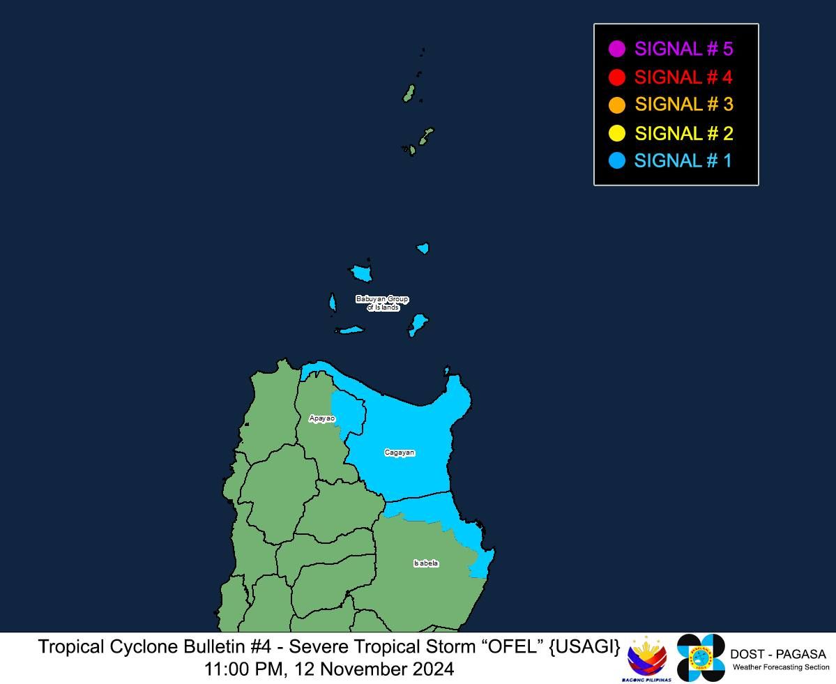
- Signal No. 1 was raised over Cagayan (including the Babuyan Islands), northeastern Isabela (Maconacon, San Pablo, Cabagan, Santa Maria, Divilacan, Palanan), and eastern Apayao (Flora, Santa Marcela, Luna, Pudtol).
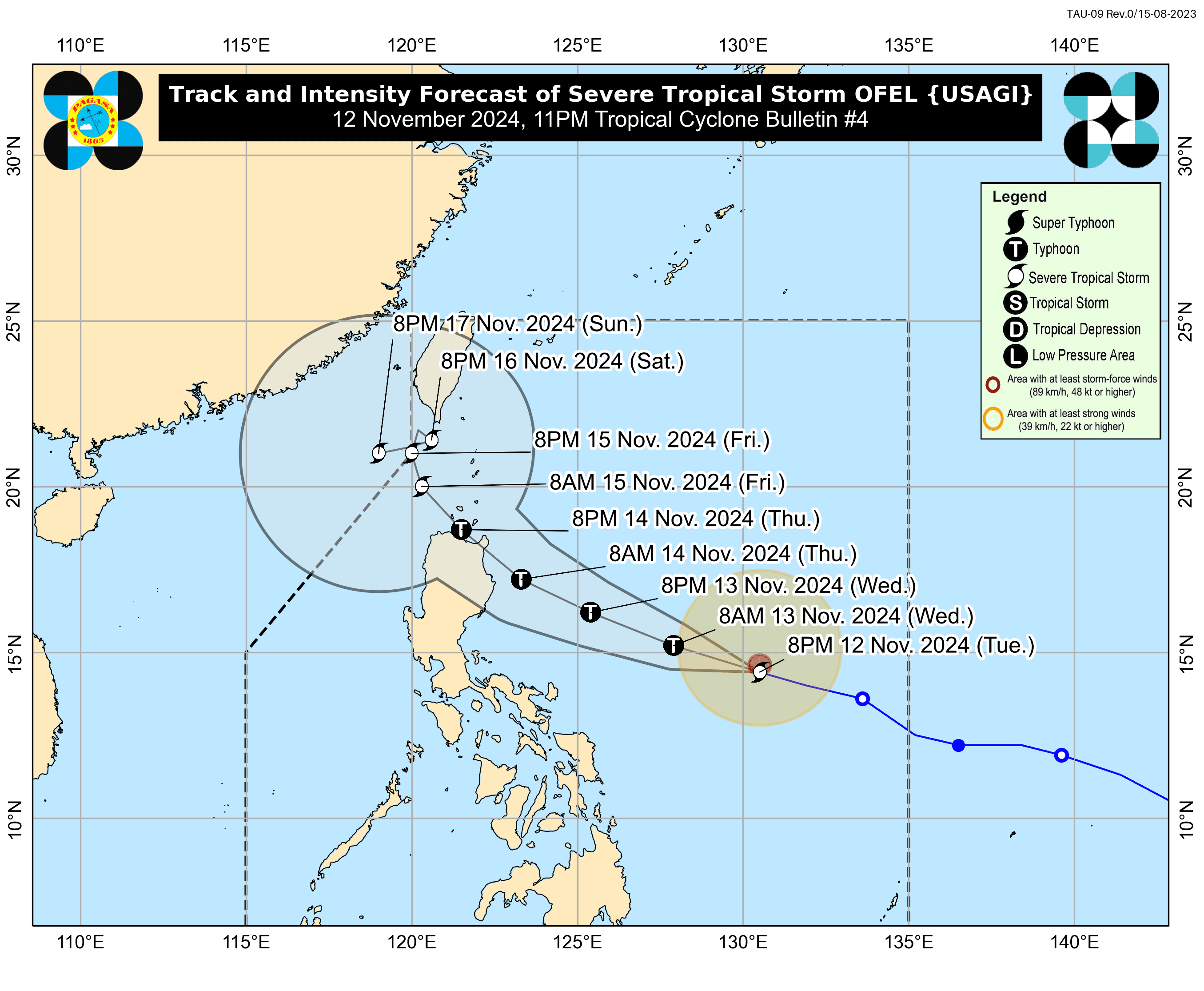
- Severe Tropical Storm Ofel (Usagi) could make landfall over the eastern parts of Cagayan or Isabela by Thursday afternoon or evening, Nov. 14.
- Ofel could intensify into a typhoon by Wednesday, Nov. 13, which would prompt the issuance of Signal No. 4.

Tropical Cyclone Wind Signal No. 1 was raised over three areas in northeastern Luzon on Tuesday evening, Nov. 12, as Severe Tropical Storm “Ofel” (international name: Usagi) continued to intensify over the Philippine Sea, said the Philippine Atmospheric, Geophysical and Astronomical Services Administration (PAGASA).
In its 11 p.m. bulletin, PAGASA raised Signal No. 1 over Cagayan (including the Babuyan Islands), northeastern Isabela (Maconacon, San Pablo, Cabagan, Santa Maria, Divilacan, Palanan), and eastern Apayao (Flora, Santa Marcela, Luna, Pudtol). It said that “minimal to minor impacts” from strong winds are expected in these areas.
Ofel has maximum sustained winds of 110 kilometers per hour (kph) near its center and gusts reaching 135 kph.
PAGASA warned that Ofel could intensify into a typhoon by Wednesday, Nov. 13, which would prompt the issuance of Signal No. 4. A tropical cyclone with wind speeds ranging from 118 and 184 kph is classified as a typhoon.
The weather bureau also warned of intense to torrential rainfall (over 200 millimeters) in Isabela and Cagayan by Wednesday.
Heavy to intense rains (100 to 200 millimeters) may also affect Apayao, Abra, Batanes, Kalinga, Mountain Province, and Ifugao, while moderate to heavy rainfall (50 to 100 millimeters) may prevail over Aurora, Ilocos Norte, Nueva Vizcaya, Benguet, Quirino, and Ilocos Sur).

Landfall
As of 10 p.m., the center of Ofel was located 630 kilometers east of Virac, Catanduanes.
PAGASA said the storm may continue its west-northwest track over the Philippine Sea and could make landfall over the eastern parts of Cagayan or Isabela by Thursday afternoon or evening, Nov. 14. The storm could make landfall at or near its peak intensity, it added.
It also noted that said Ofel’s track could shift within the forecast confidence cone, especially on the fourth and fifth days of the forecast.
Two possible scenarios are emerging: one involves a west-northwestward path with a landfall further south than currently expected, while the other suggests a recurve to the right, keeping the storm mainly offshore of Northern Luzon.
Given these possibilities, PAGASA said further adjustments to the track forecast are likely.
However, it pointed out that hazardous conditions could affect areas beyond the landfall point, including inland and coastal regions.