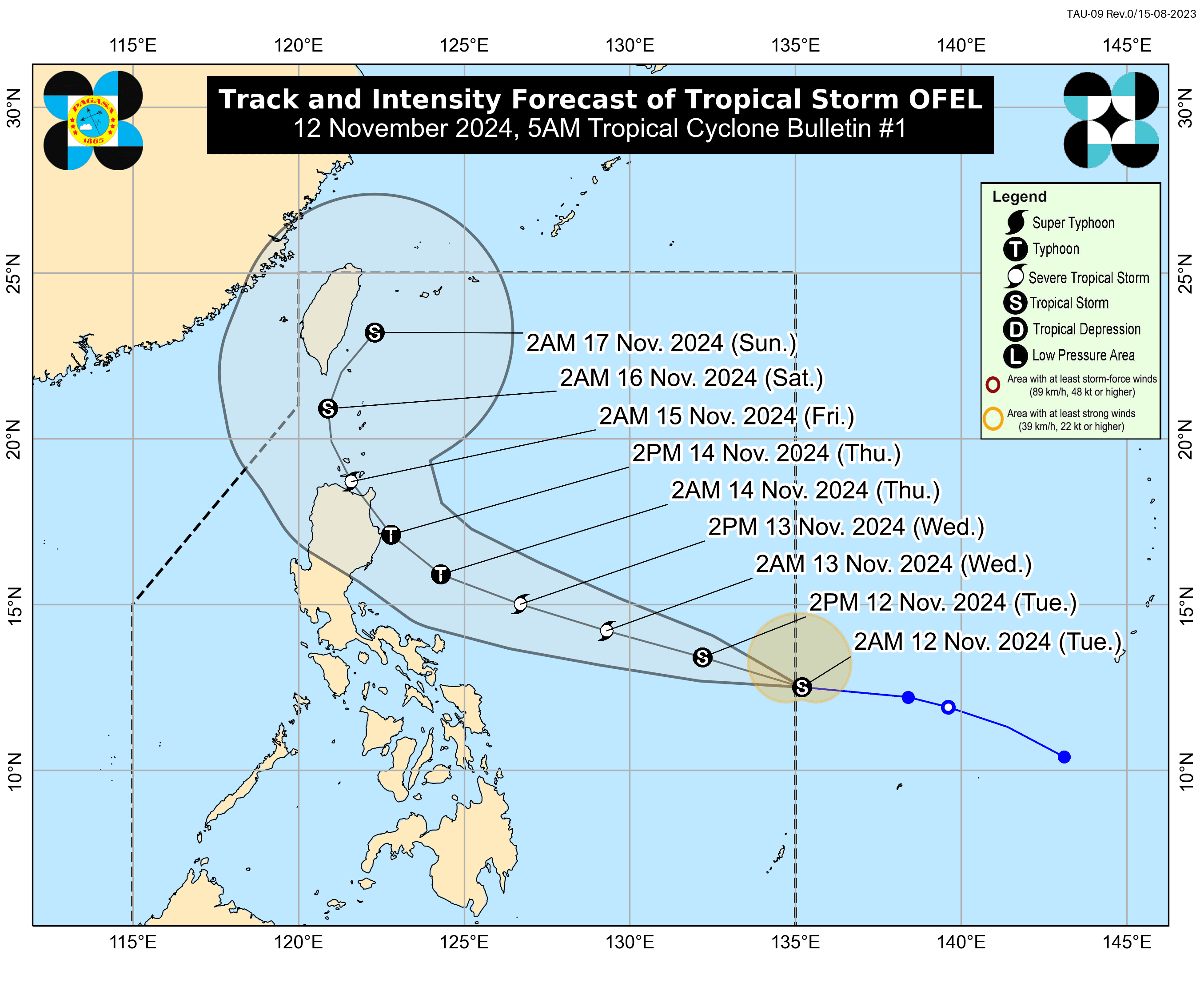
Tropical Storm Ofel enters PAR, could intensify into a typhoon
At A Glance
- Ofel may intensify into a typhoon by Wednesday, Nov. 13, and make landfall over Northern or Central Luzon by Thursday afternoon or evening, Nov. 14.
- Wind Signal No. 1 may be raised over parts of Cagayan Valley as early as Tuesday evening or Wednesday morning.
- Severe Tropical Storm "Nika" (international name: Toraji) has further weakened and is expected to exit the PAR within 12 hours.

The Philippine Atmospheric, Geophysical and Astronomical Services Administration (PAGASA) said the tropical storm east of Luzon entered the Philippine area of responsibility (PAR) on Tuesday, Nov. 12, and was named “Ofel” (international name: Usagi).
This is the third tropical cyclone to enter PAR this month and the 15th of the year.
PAGASA is closely monitoring Ofel as it may intensify into a typhoon by Wednesday, Nov. 13, and make landfall over Northern or Central Luzon by Thursday afternoon or evening, Nov. 14.
In its 5 a.m. bulletin, PAGASA said the center of Ofel was located 1,170 kilometers east of southeastern Luzon, with maximum sustained winds of 75 kilometers per hour (kph) and gusts reaching 90 kph.
Ofel will be upgraded to a typhoon once its maximum wind speed reaches 118 to 184 kph.
It is moving west-northwestward at 25 kph.
PAGASA warned that, regardless of the landfall location, hazards such as heavy rainfall, severe winds, and potential storm surges could affect areas beyond the projected landfall zone.
It said Northern Luzon is particularly at risk due to impacts that may include considerable rainfall, damaging winds, and storm surge inundation.
The eastern portions of Central and Southern Luzon could also experience significant effects if the storm expands or follows a more southerly path.
PAGASA said Wind Signal No. 1 may be raised over parts of Cagayan Valley as early as Tuesday evening or Wednesday morning.
The highest possible wind warning during Ofel’s passage is Signal No. 4.
Meanwhile, Severe Tropical Storm “Nika” (international name: Toraji) has further weakened and is expected to exit the PAR within 12 hours.
Only minimal to minor impacts from strong winds are expected in areas under Signal No. 1, which include Ilocos Norte, northern Ilocos Sur (Lidlidda, City of Candon, Galimuyod, Banayoyo, Burgos, Santiago, Santa Maria, San Esteban, Nagbukel, Narvacan, Caoayan, Santa, Bantay, City of Vigan, Santa Catalina, San Vicente, San Ildefonso, Santo Domingo, Magsingal, Cabugao, San Juan, Sinait), northern Apayao (Kabugao, Pudtol, Luna, Santa Marcela, Calanasan, Flora), northern and western parts of Abra (Tineg, Lagangilang, Bucay, Villaviciosa, Lagayan, San Juan, La Paz, Danglas, Pilar, San Isidro, Peñarrubia, Tayum, Dolores, Bangued, Pidigan, Langiden, San Quintin), western portion of Babuyan Islands (Calayan Island, Dalupiri Island, Fuga Island), and northwestern portion of mainland Cagayan (Abulug, Pamplona, Sanchez-Mira, Santa Praxedes, Claveria).
PAGASA also continues to monitor the tropical storm outside the PAR.
The tropical storm with international name “Man-yi” is also expected to enter the PAR in the coming days. Its center was located 2,870 kilometers east of southeastern Luzon at 3 a.m. on Tuesday.
The storm has maximum sustained winds of 85 kph near its center and gusts reaching 105 kph. It is moving westward at 10 kph.