


'Nika' weakens as it exits Luzon landmass — PAGASA


At A Glance
- Nika is expected to exit the Philippine area of responsibility (PAR) by Tuesday morning, Nov. 12.
- As Nika exits, a new tropical depression located around 1,300 kilometers east of Eastern Visayas will enter the PAR and be named "Ofel."
- In addition, a tropical storm with the international name "Man-yi" and located around 3,000 kilometers east of Central Luzon is expected to enter the PAR in the coming days and will be named "Pepito."
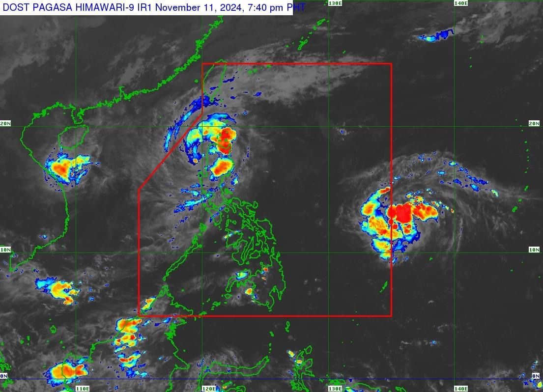
Typhoon “Nika” (international name: Toraji) weakened into a severe tropical storm after crossing the landmass of Luzon on Monday, Nov. 11.
In its 8 p.m. bulletin, the Philippine Atmospheric, Geophysical and Astronomical Services Administration (PAGASA) reported that Nika is currently over the coastal waters of Magsingal, Ilocos Sur. The storm has maximum sustained winds of 110 kilometers per hour (kph) near its center and gusts reaching 185 kph.
Moving northwestward at 20 kph, Nika is expected to exit the Philippine area of responsibility (PAR) by Tuesday morning, Nov. 12.
As the storm begins to move away, Wind Signal No. 4 has been lifted, but Signal No. 3 remains in effect in the following areas: southern Apayao (Conner, Kabugao), Abra, Kalinga, Mountain Province, Ifugao, northern Benguet (Buguias, Mankayan, Bakun), southern Ilocos Norte (Laoag City, Sarrat, San Nicolas, Piddig, Marcos, Nueva Era, Dingras, Bacarra, Solsona, Paoay, Currimao, Pinili, Badoc, City of Batac, Banna), and Ilocos Sur.
Signal No. 2 is also still in effect over southwestern Cagayan (Iguig, Alcala, Amulung, Santo Niño, Lasam, Santa Praxedes, Claveria, Sanchez-Mira, Pamplona, Abulug, Allacapan, Ballesteros, Aparri, Camalaniugan, Enrile, Tuguegarao City, Solana, Tuao, Piat, Rizal), eastern Isabela (Santo Tomas, Alicia, San Mateo, Aurora, Santa Maria, Quezon, Ramon, Roxas, Luna, Delfin Albano, City of Santiago, Reina Mercedes, San Manuel, Cabatuan, Quirino, San Isidro, Mallig, Burgos, Cordon, Cabagan), northern Quirino (Diffun, Cabarroguis, Saguday), northern Nueva Vizcaya (Bambang, Kayapa, Santa Fe, Aritao, Quezon, Bayombong, Ambaguio, Solano, Bagabag, Diadi, Villaverde, Dupax del Sur, Dupax del Norte, Kasibu), La Union, the rest of Ilocos Norte, the rest of Apayao, and the rest of Benguet.
Signal No. 1 remains up over Pangasinan, the rest of Cagayan (including Babuyan Islands), the rest of Isabela, the rest of Quirino, the rest of Nueva Vizcaya, Tarlac, northern and central portions of Zambales (Santa Cruz, Candelaria, Masinloc, Palauig, Iba, Botolan, Cabangan), Nueva Ecija, and Aurora.
Heavy to intense rainfall (100 to 200 millimeters) is expected to continue through Tuesday evening in Cagayan, Apayao, Kalinga, Mountain Province, Abra, Benguet, Ifugao, Ilocos Norte, Isabela, Ilocos Sur, and La Union.
Meanwhile, moderate to heavy rainfall (50 to 100 millimeters) may persist in Aurora, Nueva Vizcaya, Quirino, Nueva Ecija, Tarlac, and Pangasinan.
As Nika exits on Tuesday, a new tropical depression located 1,375 kilometers east of Eastern Visayas will enter the PAR and be named “Ofel.”
In addition, a tropical storm with the international name “Man-yi” and located 3,390 kilometers east of Central Luzon is expected to enter the PAR in the coming days and will be named “Pepito.”