


 Philippines
National
Signal No. 3 raised in 13 areas as 'Kristine' intensifies into severe tropical storm
Philippines
National
Signal No. 3 raised in 13 areas as 'Kristine' intensifies into severe tropical storm
Signal No. 3 raised in 13 areas as 'Kristine' intensifies into severe tropical storm
Metro Manila, 6 other Luzon regions brace for stormy weather


At A Glance
- Severe Tropical Storm Kristine is moving northwestward at 20 kph and is expected to make landfall in Isabela on Wednesday evening or early Thursday morning, Oct. 24.
- After landfall, Kristine may cross Northern Luzon's mountainous terrain and emerge over the waters west of Ilocos Region on Thursday morning.
- Due to Kristine's vast circulation, stormy weather—characterized by intense to torrential rains and strong winds—may prevail across Metro Manila, Cagayan Valley, Ilocos Region, Cordillera Administrative Region, Central Luzon, Calabarzon, and Bicol Region.
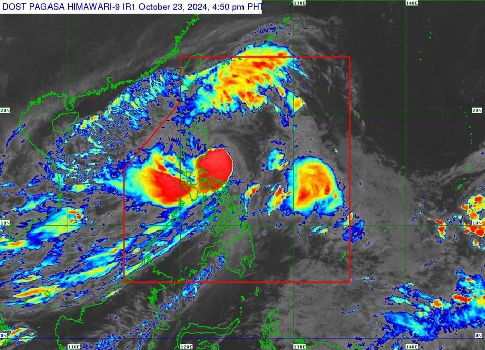
Thirteen areas in Luzon were placed under tropical cyclone wind Signal No. 3 on Wednesday afternoon, Oct. 23, as “Kristine” (international name “Trami”) strengthened into a severe tropical storm ahead of its anticipated landfall in Isabela.
Based on PAGASA’s 5 p.m. bulletin, Signal No. 3 is in effect in Isabela, Kalinga, Mountain Province, Ifugao, central portion of Abra (Malibcong, Licuan Baay, Sallapadan, Daguioman, Bucloc, Boliney, Tubo, Luba, Manabo, Bucay, Villaviciosa, Pilar, San Isidro, Pe), Benguet, Quirino, Nueva Vizcaya, northern and central portions of Aurora (Dilasag, Casiguran, Dinalungan, Dipaculao, Maria Aurora, Baler), northern portion of Nueva Ecija (Carranglan, Lupao, San Jose City, Pantabangan), Pangasinan, La Union, and central and southern portions of Ilocos Sur (Cervantes, Quirino, Sigay, Suyo, Alilem, Sugpon, Tagudin, Santa Cruz, Salcedo, Gregorio del Pilar, San Emilio, Lidlidda, Burgos, San Esteban, Santiago, Banayoyo, Galimuyod, City of Candon, Santa Lucia, Nagbukel, Santa Maria, Narvacan).
Meanwhile, Signal No. 2 is up in Metro Manila, Ilocos Norte, the rest of Ilocos Sur, Apayao, the rest of Abra, Cagayan (including Babuyan Islands), the rest of Aurora, the rest of Nueva Ecija, Bulacan, Tarlac, Pampanga, Zambales, Bataan, Cavite, Laguna, Rizal, Quezon (including Polillo Islands), Camarines Norte, Camarines Sur, and Catanduanes.
Areas placed under Signal No. 1 are Batanes, Batangas, Occidental Mindoro (including Lubang Islands), Oriental Mindoro, Marinduque, Romblon, Calamian Islands, Albay, Sorsogon, Masbate (including Ticao and Burias Islands), Aklan, Capiz, Antique (including Caluya Islands), Iloilo, Guimaras, northern portion of Negros Occidental (Pontevedra, La Castellana, Moises Padilla, Bago City, La Carlota City, Valladolid, Pulupandan, Bacolod City, San Enrique, Murcia, Silay City, City of Talisay, Enrique B. Magalona, Manapla, City of Victorias, Cadiz City, Sagay City, City of Escalante, Toboso, Calatrava, Salvador Benedicto, San Carlos City), northern portion of Negros Oriental (Vallehermoso, Canlaon City, City of Guihulngan), northern and central portions of Cebu (Alcantara, Argao, Dumanjug, Sibonga, Pinamungahan, Ronda, Liloan, Cebu City, Moalboal, Consolacion, Danao City, Borbon, Carmen, Daanbantayan, Tuburan, City of Bogo, Tabogon, City of Naga, Lapu-Lapu City, City of Carcar, Mandaue City, Catmon, Minglanilla, Toledo City, Cordova, Compostela, San Remigio, Balamban, Aloguinsan, San Fernando, Asturias, Barili, Medellin, Sogod, Tabuelan, City of Talisay), including Bantayan Islands and Camotes Islands, Bohol, Eastern Samar, Northern Samar, Samar, Leyte, Biliran, Southern Leyte, Dinagat Islands, and Surigao del Norte (including Siargao-Bucas Grande Group).
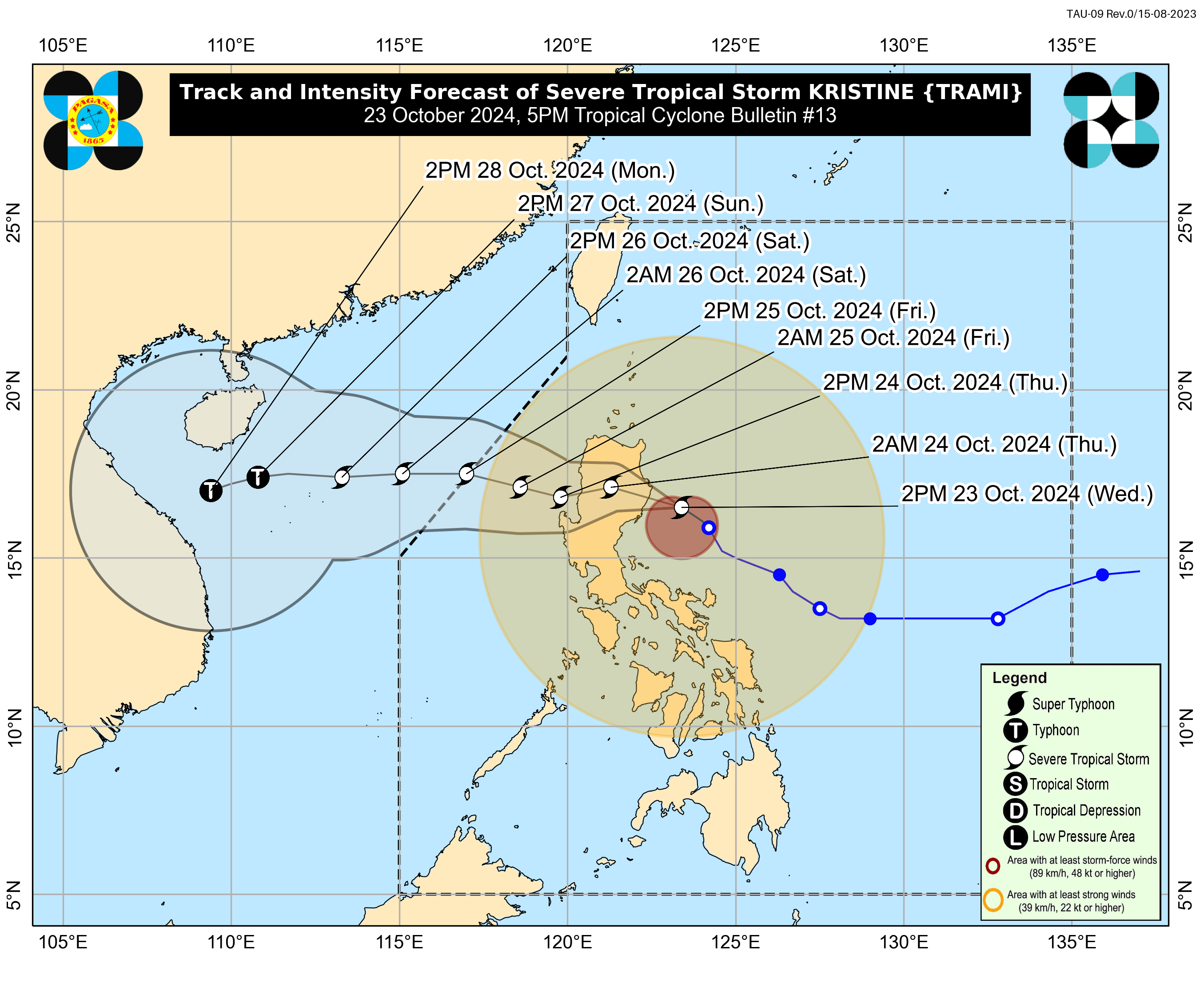
As of 4 p.m., the center of Kristine was located 175 kilometers east of Echague, Isabela, with maximum sustained winds of 95 kilometers per hour (kph) near the center and gusts reaching up to 115 kph.
It is moving northwestward at 20 kph and is expected to make landfall in Isabela on Wednesday evening or early Thursday morning, Oct. 24.
After landfall, Kristine may cross Northern Luzon’s mountainous terrain and emerge over the waters west of Ilocos Region on Thursday morning.
Due to Kristine’s vast circulation, stormy weather—characterized by intense to torrential rains and strong winds—may prevail across Metro Manila, Cagayan Valley, Ilocos Region, Cordillera Administrative Region, Central Luzon, Calabarzon, and Bicol Region.
Moderate to intense rains may also affect Visayas, Mimaropa, Dinagat Islands, and Surigao del Norte.
Meanwhile, the trough or extension of Kristine may bring moderate to heavy rains to Zamboanga Peninsula, Northern Mindanao, Bangsamoro Autonomous Region in Muslim Mindanao, and Soccsksargen.
The rest of Mindanao may experience isolated rain showers or thunderstorms.
PAGASA warned that the rainy conditions could lead to flooding and landslides, particularly in areas identified as highly or very highly susceptible to these hazards and in areas with significant antecedent rainfall.
Kristine is expected to exit the Philippine Area of Responsibility by Friday, Oct. 25.