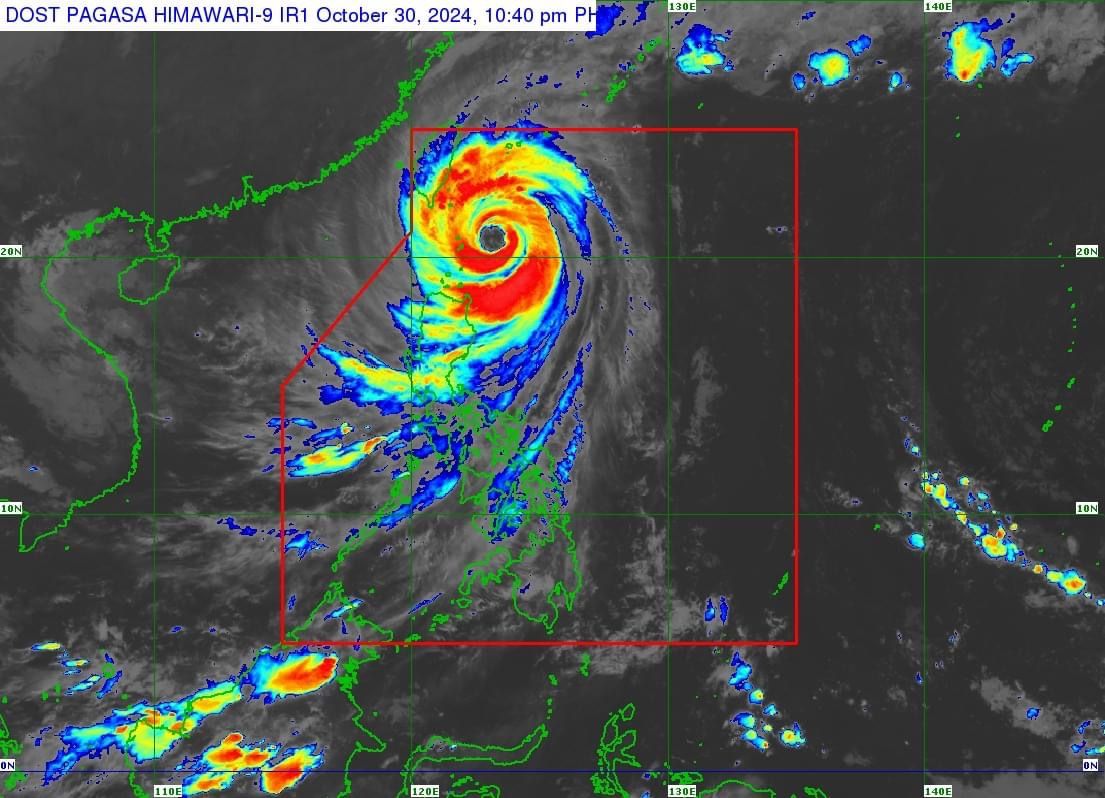
Batanes experiences 'violent conditions' as 'Leon' moves closer; Signal No. 5 raised
At A Glance
- Leon is expected to be closest to Batanes between Wednesday evening, Oct. 30, and Thursday morning, Oct. 31.
- However, a landfall in the area remains a possibility.
- "Violent conditions area [already] being experienced" in the province, PAGASA said.

The Philippine Atmospheric, Geophysical and Astronomical Services Administration (PAGASA) raised Signal No. 5 over parts of Batanes on Wednesday evening, Oct. 30, as Super Typhoon “Leon” (international name: Kong-rey) moves closer to extreme Northern Luzon.
As of 10 p.m., the center of the eye of Leon was located 140 kilometers east of Basco, Batanes, and is expected to be closest to the province between Wednesday evening and Thursday morning, Oct. 31.
However, PAGASA said a landfall in the area remains a possibility.
The super typhoon currently has maximum sustained winds of 185 kilometers per hour (kph) near its center and gusts reaching 230 kph.
PAGASA said “Leon will be near or at peak intensity during its closest point of approach to Batanes,” and reported that “violent conditions area [already] being experienced” in the province, as of 11 p.m. on Wednesday.
Wind signals
Signal No. 5 has been raised over the northern and eastern portions of Batanes (Itbayat, Basco), while Signal No. 4 remains in effect the rest of Batanes.
Meanwhile, Signal No. 3 remains in place in the eastern portion of Babuyan Islands (Babuyan Island, Camiguin Island, Calayan Island), and northeastern portion of mainland Cagayan (Santa Ana).
Signal No. 2 is also hoisted over the rest of Babuyan Islands, the rest of mainland Cagayan, northern portion of Isabela (Santo Tomas, Santa Maria, Quezon, Delfin Albano, San Pablo, Ilagan City, Tumauini, Cabagan, Palanan, Quirino, Divilacan, Mallig, Maconacon), Apayao, northern portion of Kalinga (City of Tabuk, Balbalan, Pinukpuk, Rizal), northern portion of Abra (Tineg, Lacub, Malibcong), and Ilocos Norte.
Signal No. 1 is up over the rest of Isabela, Quirino, Nueva Vizcaya, the rest of Abra, the rest of Kalinga, Mountain Province, Ifugao, Benguet, Ilocos Sur, La Union, northern and central portions of Pangasinan (Basista, Lingayen, Villasis, City of Alaminos, Anda, Malasiqui, Tayug, San Fabian, Mangaldan, Mapandan, Burgos, Dagupan City, Binalonan, Bolinao, Alcala, San Manuel, Sual, Umingan, Asingan, Labrador, Bani, Santo Tomas, Pozorrubio, San Quintin, Santa Maria, City of Urdaneta, Laoac, Natividad, Mabini, San Carlos City, Manaoag, Binmaley, San Jacinto, Bugallon, Agno, Calasiao, San Nicolas, Santa Barbara, Balungao, Sison, Rosales, Dasol), northern and eastern portions of Nueva Ecija (Bongabon, Carranglan, Pantabangan, Laur, Rizal, Cuyapo, Talavera, Santo Domingo, Llanera, Science City of Mu oz, General Mamerto Natividad, San Jose City, Lupao, Talugtug, Gabaldon), and northern and central portions of Aurora (Casiguran, Dinalungan, Baler, Maria Aurora, Dipaculao, San Luis, Dilasag).
Rainfall outlook
Based on PAGASA’s three-day rainfall forecast, moderate to torrential rainfall is anticipated in parts of Luzon and Visayas.
From Wednesday to Thursday afternoon, intense to torrential rainfall (over 200 millimeters) is expected in Batanes, Cagayan, and Babuyan Islands.
Heavy to intense rainfall (100 to 200 millimeters) may affect Ilocos Norte, Ilocos Sur, Apayao, Abra, Isabela, Occidental Mindoro, Calamian Islands, and Antique, while moderate to heavy rains (50 to 100 millimeters) are likely in Kalinga, Benguet, Mountain Province, La Union, Pangasinan, and Negros Occidental.
The trough or extension of Leon may also bring scattered light to moderate rain showers and thunderstorms to Metro Manila, Visayas, and the rest of Luzon.
From Thursday afternoon to Friday afternoon, Nov. 1, intense to torrential rainfall is expected to continue in Batanes, while heavy to intense rains may persist in Babuyan Islands.
Meanwhile, moderate to heavy rainfall may continue to affect mainland Cagayan, Occidental Mindoro, Ilocos Norte, Zambales, Bataan, Cavite, Batangas, and Calamian Islands.
From Friday afternoon to Saturday afternoon, Nov. 2, rainfall is expected to decrease, with only moderate to heavy precipitation expected in Batanes.
The super typhoon is expected to weaken after its landfall in Taiwan.
After crossing Taiwan, Leon will move north northwestward to northeastward over the Taiwan Strait and exit the Philippine Area of Responsibility by Thursday evening or early Friday morning, Nov. 1.