Signal No. 3 up over parts of extreme N. Luzon due to 'Leon'
At A Glance
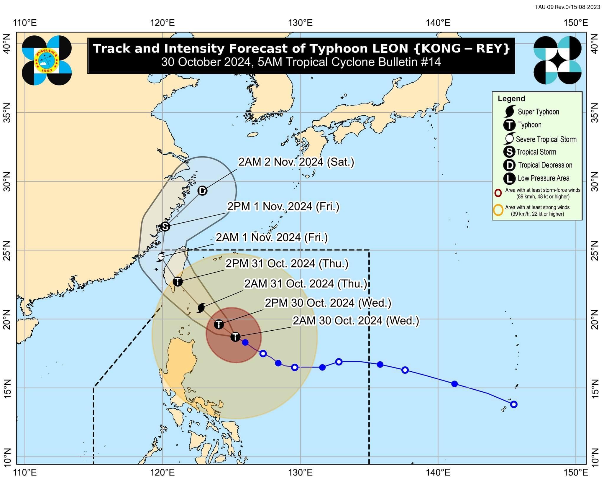
- As of 4 a.m., the center of the typhoon was located 395 kilometers east of Calayan, Cagayan, moving west northwestwardat 15 kph.
- It will be closest to Batanes between early morning and noon on Thursday. Oct. 31. However, a landfall in Batanes is still possible.
- Leon has maximum sustained winds of 165 kilometers per hour (kph) near its center and gusts reaching 205 kph.
- It may become a super typhoon once it reaches a maximum wind speed of 185 kph.

The Philippine Atmospheric, Geophysical and Astronomical Services Administration (PAGASA) raised Wind Signal No. 3 over parts of extreme Northern Luzon, as Typhoon “Leon” (international name: Kong-rey) strengthened further while traversing the Philippine Sea on Wednesday morning, Oct. 30.
As of 5 a.m., Leon has maximum sustained winds of 165 kilometers per hour (kph) near its center and gusts reaching 205 kph.
“Leon will likely be at or near super typhoon intensity during its closest point of approach to Batanes,” PAGASA warned. A super typhoon has a maximum wind speed of over 185 kph.
In preparation for Leon’s strong winds, Signal No. 3 has been raised in Batanes and the eastern portion of Babuyan Islands on Wednesday morning.
Signal No. 2 remains in effect in the rest of Babuyan Islands, Cagayan, northern and eastern portions of Isabela (Santo Tomas, Santa Maria, Quezon, San Mariano, Naguilian, Dinapigue, Delfin Albano, San Pablo, Ilagan City, Benito Soliven, Tumauini, Cabagan, Palanan, Quirino, Divilacan, Gamu, Mallig, Maconacon, Burgos, City of Cauayan, San Guillermo, Angadanan, Cabatuan, Luna, Reina Mercedes, Roxas, Aurora, San Manuel), Apayao, Kalinga, northern and eastern portions of Abra (Tineg, Lacub, Malibcong, Lagayan, San Juan, Lagangilang, Licuan-Baay, Daguioman), eastern portion of Mountain Province (Paracelis), and Ilocos Norte.
Signal No. 1 is in place in the rest of Isabela, Quirino, Nueva Vizcaya, the rest of Mountain Province, Ifugao, Benguet, the rest of Abra, Ilocos Sur, La Union, Pangasinan, Nueva Ecija, Aurora, northeastern portion of Tarlac (Camiling, San Clemente, Paniqui, Moncada, Anao, San Manuel, Pura, Ramos, Victoria, Gerona, Santa Ignacia, City of Tarlac, La Paz), the northern portion of Bulacan (Doña Remedios Trinidad, San Miguel), northern portion of Quezon (Infanta, General Nakar, including Polillo Islands), Camarines Norte, northern portion of Camarines Sur (Siruma, Tinambac, Lagonoy, Garchitorena, Caramoan), and northern and eastern portions of Catanduanes (Pandan, Gigmoto, Bagamanoc, Panganiban, Viga, Baras, Caramoran).
PAGASA said the highest wind signal that could be raised during the passage of Leon is Signal No. 4. However, the hoisting of Signal No. 5 is still not ruled out.
Forecast track
As of 4 a.m., the center of the typhoon was located 395 kilometers east of Calayan, Cagayan, moving west northwestwardat 15 kph.
PAGASA said Leon is expected to move northwestward over the Philippine Sea until it makes landfall along the eastern coast of Taiwan on Thursday afternoon, Oct. 31.
It will be closest to Batanes between early morning and noon on Thursday. However, a landfall in Batanes is still possible.
After crossing Taiwan, Leon is projected to move north northwestward to northeastward through the Taiwan Strait toward the East China Sea and exit the Philippine Area of Responsibility by Thursday evening or early Friday morning, Nov. 1.
A second landfall in mainland China is also possible.
Rainfall outlook
Based on PAGASA’s three-day rainfall forecast, moderate to torrential rainfall is anticipated in parts of Luzon and Visayas.
On Wednesday, intense to torrential rainfall (over 200 millimeters) is expected in Batanes, Cagayan, and Babuyan Islands.
Heavy to intense rainfall (100 to 200 millimeters) may affect Ilocos Norte, Apayao, Isabela, and Occidental Mindoro, while moderate to heavy rains (50 to 100 millimeters) are likely in Ilocos Sur, Abra, Kalinga, Benguet, La Union, Pangasinan, Calamian Islands, Occidental Mindoro, Romblon, and Antique.
The trough or extension of Leon may also bring scattered light to moderate rain showers and thunderstorms to Metro Manila, Visayas, and the rest of Luzon.
On Thursday, Oct. 31, intense to torrential rainfall is expected to continue in Batanes, while heavy to intense rains may persist in Babuyan Islands.
Meanwhile, moderate to heavy rainfall may continue to affect mainland Cagayan, Occidental Mindoro, Ilocos Norte, Zambales, Bataan, Cavite, Batangas, and Calamian Islands.
By Friday, rainfall is expected to decrease, with only moderate to heavy precipitation expected in Batanes.