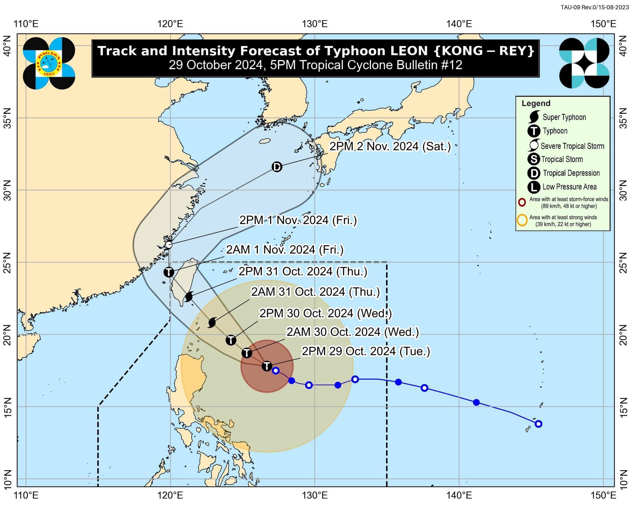
'Leon' rapidly intensifies, may become a super typhoon as early as October 30
Take vigilance seriously, says PAGASA chief
At A Glance
- Leon will likely be closest to Batanes between early morning and noon on Thursday, Oct. 31.
- Stormy weather is also expected across Northern Luzon during the passage of the typhoon.
- The trough or extension of Leon may also bring scattered light to moderate rain showers and thunderstorms to Metro Manila, Visayas, and the rest of Luzon.

Eight areas are now under Tropical Cyclone Wind Signal No. 2 as Typhoon “Leon” (international name: Kong-rey) undergoes rapid intensification while over the waters east of Cagayan on Tuesday afternoon, Oct. 29.
In the PAGASA’s 5 p.m. bulletin, Signal No. 2 was in effect in Batanes, Babuyan Islands, mainland Cagayan, northern and eastern portions of Isabela (Santo Tomas, Santa Maria, Quezon, San Mariano, Naguilian, Dinapigue, Delfin Albano, San Pablo, Ilagan City, Benito Soliven, Tumauini, Cabagan, Reina Mercedes, Palanan, Quirino, Divilacan, Gamu, Mallig, Maconacon, Burgos), Apayao, northern portion of Kalinga (City of Tabuk, Balbalan, Pinukpuk, Rizal), northern portion of Abra (Tineg, Lacub, Malibcong), and Ilocos Norte.
Meanwhile, Signal No. 1 remains in effect in the rest of Isabela, Quirino, Nueva Vizcaya, the rest of Kalinga, Mountain Province, Ifugao, Benguet, the rest of Abra, Ilocos Sur, La Union, eastern portion of Nueva Ecija (General Tinio, Gabaldon, Bongabon, Carranglan, Pantabangan, Laur, Rizal), Aurora, northern and eastern portions of Quezon (Infanta, Real, Mauban, Perez, Alabat, Quezon, Calauag, General Nakar, Atimonan, Plaridel, Gumaca, Lopez, Guinayangan, Tagkawayan, including Polillo Islands), Camarines Norte, Camarines Sur, Catanduanes, Albay, and northern portion of Sorsogon (Prieto Diaz, City of Sorsogon, Gubat, Barcelona, Casiguran, Bulusan, Juban, Magallanes, Castilla, Pilar, Donsol).
PAGASA expects that Signal No. 3 or 4 may be raised, especially in Batanes and Babuyan Islands, as Leon continues to intensify and approach extreme Northern Luzon.
There is also a possibility that Signal No. 5 could be issued if Leon develops into a super typhoon, with a maximum wind speed of over 185 kph.
In a PAGASA press conference on Tuesday afternoon, Administrator Nathaniel Servando said Leon is undergoing rapid intensification and could reach super typhoon status “as early as Wednesday (Oct. 30).”
As of 5 p.m., the typhoon has maximum sustained winds of 150 kilometers per hour (kph) near its center and gusts reaching 185 kph.
The center of the typhoon was located 505 kilometers east of Tuguegarao City, Cagayan, or 515 kilometers east of Aparri, Cagayan, moving west-northwestward at 10 kph.
Servando warned that the typhoon poses a significant threat to extreme Northern Luzon, including the Batanes group of islands, which is expected to experience stormy weather starting Tuesday.
Batanes was affected by Typhoon Julian on Oct. 1, and it is again anticipated to be directly impacted by Typhoon Leon, he pointed out.
Leon will likely be closest to Batanes between early morning and noon on Thursday, Oct. 31.
While Leon is currently moving generally toward Taiwan, there remains a likelihood of a westward shift in its forecast track, which means landfall in Batanes cannot be ruled out.
Servando said stormy weather is also expected across Northern Luzon during the passage of the typhoon.
Rainfall outlook
Based on PAGASA’s three-day rainfall forecast, moderate to torrential rainfall is expected in parts of Luzon and Visayas.
From Tuesday to Wednesday afternoon, intense to torrential rainfall (over 200 millimeters) may affect Batanes, Cagayan, and Babuyan Islands.
Heavy to intense rainfall (100 to 200 millimeters) is expected over Ilocos Norte, Apayao, Isabela, Occidental Mindoro, and Antique, while moderate to heavy rains (50 to 100 millimeters) may be experienced in Ilocos Sur, Abra, Kalinga, Calamian Islands, Romblon, Negros Occidental, and Aklan.
From Wednesday afternoon to Thursday afternoon, intense to torrential will likely continue in Batanes, Cagayan, Babuyan Islands, and Occidental Mindoro.
Ilocos Norte, Ilocos Sur, Apayao, Isabela, Calamian Islands, and Antique may also experience heavy to intense rains, while Abra, Bataan, Bulacan, Rizal, Laguna, Cavite, Batangas, Romblon, and Aklan may receive moderate to heavy rainfall.
From Thursday afternoon to Friday afternoon, Nov. 1, Batanes and Babuyan Islands may continue to experience intense to torrential rainfall.
Heavy to intense rains are also expected in mainland Cagayan, Calamian Islands, and Occidental Mindoro, while moderate to heavy precipitation may prevail over Ilocos Norte, Zambales, Bataan, Cavite, Batangas, Romblon, and Antique.
The trough or extension of Leon may also bring scattered light to moderate rain showers and thunderstorms to Metro Manila, Visayas, and the rest of Luzon.
‘Take vigilance seriously’
Servando urged the public to treat the situation seriously and take necessary precautions in preparation for the potential impacts of Typhoon Leon.
“Sa ating mga kababayan, muli pinapayuhan na seryosohin dapat natin ang pagiging alerto at paghahanda sa posibleng epekto ng bagyong Leon. Ang inaasahang malalakas na pag-ulan ay magdudulot ng mga pagbaha at landslides (To our fellow citizens, we urge you to take the situation seriously and remain vigilant in your preparations for the potential impacts of Typhoon Leon. The anticipated heavy rainfall poses a significant risk of flooding),” he said.
For those scheduled to travel, particularly to areas under storm signals, Servando recommended exercising extreme caution, especially to Northern Luzon.
“Maaaring dobleng pag-iingat kung hindi maiwasan na i-cancel ang pagbiyahe, particularly patungong Northern Luzon (Extreme caution is advised if travel cannot be avoided, particularly to Northern Luzon),” he said.
Leon is expected to exit the Philippine Area of Responsibility on Thursday evening or early Friday morning.