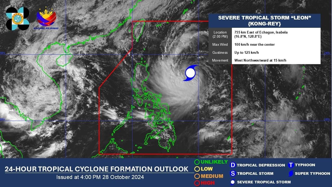
'Leon' could become a typhoon within 24 hours; 23 areas under Signal No. 1
At A Glance
- "Leon" is expected to continue to intensify over the Philippine Sea and may reach typhoon category within the next 24 hours.
- There is also an increasing likelihood that it could reach super typhoon strength as it nears Batanes.
- Should it intensify into a super typhoon, PAGASA said the possibility of raising Signal No. 5 cannot be ruled out.

Severe Tropical Storm “Leon” (international name: Kong-rey) further intensified while traversing the Philippine Sea, prompting the Philippine Atmospheric, Geophysical and Astronomical Services Administration (PAGASA) to issue Wind Signal No. 1 in 23 areas across Luzon and Visayas on Monday afternoon, Oct. 28.
In its 5 p.m. bulletin, PAGASA reported that Leon has maximum sustained winds of 100 kilometers per hour (kph) near its center and gustiness of 125 kph.
In anticipation of the storm’s strong winds, Signal No. 1 was raised in Batanes, Cagayan (including Babuyan Islands), Isabela, Quirino, Nueva Vizcaya, Apayao, Kalinga, Abra, Mountain Province, Ifugao, the northern portion of Benguet (Bakun, Kibungan, Atok, Bokod, Mankayan, Buguias, Kabayan), Ilocos Norte, Ilocos Sur, La Union, Aurora, northern portion of Quezon(General Nakar, Infanta, Real, including Polillo Islands), Camarines Norte, eastern portion of Camarines Sur (Tinambac, Siruma, Goa, Lagonoy, San Jose, Garchitorena, Caramoan, Presentacion, Tigaon, Calabanga, Saglay), Catanduanes, eastern portion of Albay (Rapu-Rapu, Bacacay, City of Tabaco, Tiwi, Malilipot, Malinao, Santo Domingo, Manito), northeastern portion of Sorsogon (Prieto Diaz, City of Sorsogon, Gubat), eastern portion of Northern Samar (San Roque, Pambujan, Catubig, Laoang, Palapag, Gamay, Lapinig, Mapanas, Mondragon), and northern portion of Eastern Samar (Jipapad, Arteche, Oras, San Policarpo).
PAGASA said Leon is expected to continue to intensify over the Philippine Sea and may reach typhoon category within the next 24 hours.
There is also an increasing likelihood that it could reach super typhoon strength as it nears Batanes.
The highest wind signal that may be issued during Leon’s passage is Signal No. 3 or 4, particularly in extreme Northern Luzon.
Should it intensify into a super typhoon, PAGASA said the possibility of raising Signal No. 5 cannot be ruled out.
Heavy rainfall outlook
Moderate to torrential rains may affect several parts of the country, mostly in Luzon, based on PAGASA’s three-day rainfall forecast.
From Monday to Tuesday afternoon, Oct. 29, the trough or extension of Leon may bring heavy to intense rainfall (100 to 200 millimeters) to Antique, while moderate to heavy rainfall (50 to 100 millimeters) may affect Cagayan, Babuyan Islands, Occidental Mindoro, Negros Occidental, and Palawan.
From Tuesday afternoon to Wednesday afternoon, Oct. 30, intense to torrential rainfall (over 200 millimeters) may be felt in Antique, Cagayan, and Babuyan Islands.
Heavy to intense rainfall is expected in Occidental Mindoro, Batanes, and Apayao, while moderate to heavy rainfall may prevail over Ilocos Norte, Ilocos Sur, Negros Occidental, Aklan, Cavite, and Palawan.
From Wednesday afternoon to Thursday afternoon, Oct. 31, heavy to intense rains may be recorded in Batanes, Babuyan Islands, Occidental Mindoro, and Cavite, while moderate to heavy rainfall is expected in Ilocos Region, Antique, Palawan, Zambales, Bataan, and Batangas.
The rest of the country will be partly cloudy to cloudy with isolated rain showers due to localized thunderstorms.
Forecast track
As of 4 p.m., the center of the severe tropical storm was located 725 kilometers east of Echague, Isabela, moving west northwestward at 15 kph.
PAGASA said Leon may continue to move west northwestward until Tuesday morning, then shift northwestward until it makes landfall along Taiwan’s eastern coast on Thursday afternoon or evening.
After crossing Taiwan, Leon is expected to turn northeast toward the East China Sea and exit the Philippine Area of Responsibility on Friday morning or afternoon, Nov. 1.
However, PAGASA said there is an increasing likelihood of a westward shift in Leon’s forecast track, raising the possibility of a landfall or close approach to Batanes.
PAGASA advised the public to continue monitoring official updates regarding this weather disturbance as forecasts may still change.