


 Philippines
National
As 'Kristine' exits, tropical depression near PAR intensifies into storm
Philippines
National
As 'Kristine' exits, tropical depression near PAR intensifies into storm
As 'Kristine' exits, tropical depression near PAR intensifies into storm


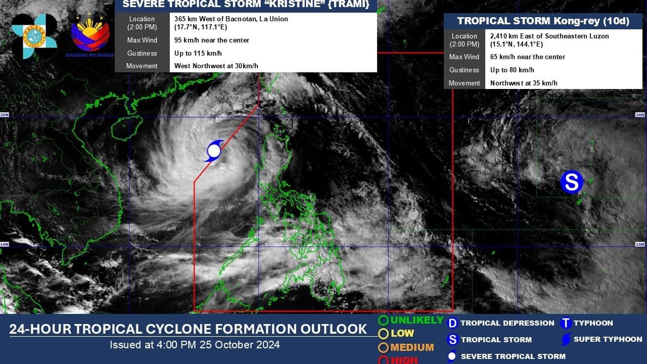
As Severe Tropical Storm “Kristine” (international name “Trami”) exited the Philippine Area of Responsibility (PAR) on Friday afternoon, Oct. 25, the tropical depression outside the PAR intensified into a tropical storm, which was assigned the international name “Kong-rey.”
In its 5 p.m. bulletin, the Philippine Atmospheric, Geophysical and Astronomical Services Administration (PAGASA) said Kristine was last located 410 kilometers west of Sinait, Ilocos Sur, moving west-northwestward at 30 kilometers per hour (kph).
It maintained maximum sustained winds of 95 kph near the center and gusts of up to 115 kph.
Wind Signal No. 2 has been lifted, but Signal No. 1 remains in effect in Ilocos Norte, Ilocos Sur, La Union, Pangasinan, Apayao, Kalinga, Abra, Mountain Province, Ifugao, Benguet, Cagayan including Babuyan Islands, Isabela, Quirino, Nueva Vizcaya, Nueva Ecija, Tarlac, Zambales, Bataan, Pampanga, Bulacan, Metro Manila, northern portion of Rizal (Cainta, Rodriguez, San Mateo, City of Antipolo, Taytay), and northern portion of Cavite (Ternate, Naic, Tanza, Rosario, Bacoor City, Kawit, Noveleta, Cavite City, City of General Trias, Imus City, Maragondon).
All storm surge warnings have also been lifted.
Meanwhile, PAGASA said moderate to heavy rainfall may continue in Ilocos Region, Zambales, and Bataan over the next 24 hours due to Kristine.
The trough or extension of the storm may also bring scattered rains and thunderstorms to Metro Manila and the rest of Luzon.
The southwesterly wind flow enhanced by Kristine may cause cloudy conditions and scattered rains and thunderstorms across the Visayas, Zamboanga Peninsula, and Northern Mindanao, while isolated rain showers or thunderstorms may affect the rest of Mindanao.
Kristine’s comeback
PAGASA said Kristine will continue to move westward over the West Philippine Sea until Saturday, Oct. 26, then loop counterclockwise on Sunday and Monday, Oct. 27 and 28.
It will eventually move eastward in the succeeding days.
However, PAGASA said Kristine’s path will depend on the behavior of Kong-rey located east of the PAR and other surrounding weather systems while it hovers over the West Philippine Sea.
As of 2 p.m., the tropical storm, which could influence the track of Kristine and trigger a Fujiwhara effect, was located 2,410 kilometers east of southeastern Luzon.
Having intensified from a tropical depression, Kong-rey now has maximum sustained winds of 65 kph near the center and gusts of up to 80 kph.
PAGASA said it may enter the PAR by Sunday, where it will be assigned the local name “Leon.”
READ MORE: https://mb.com.ph/2024/10/25/pagasa-explains-possibility-of-kristine-s-return