


'Kristine' traverses Cordillera; LPA forms outside PAR


At A Glance
- Kristine has maintained a vast circulation with a diameter of about 1,400 to 1,500 kilometers that is continuously affecting Luzon and parts of the Visayas.
- It will continue to cross Northern Luzon over the next 12 hours and is expected to emerge over the waters west of Ilocos Region by Thursday afternoon.
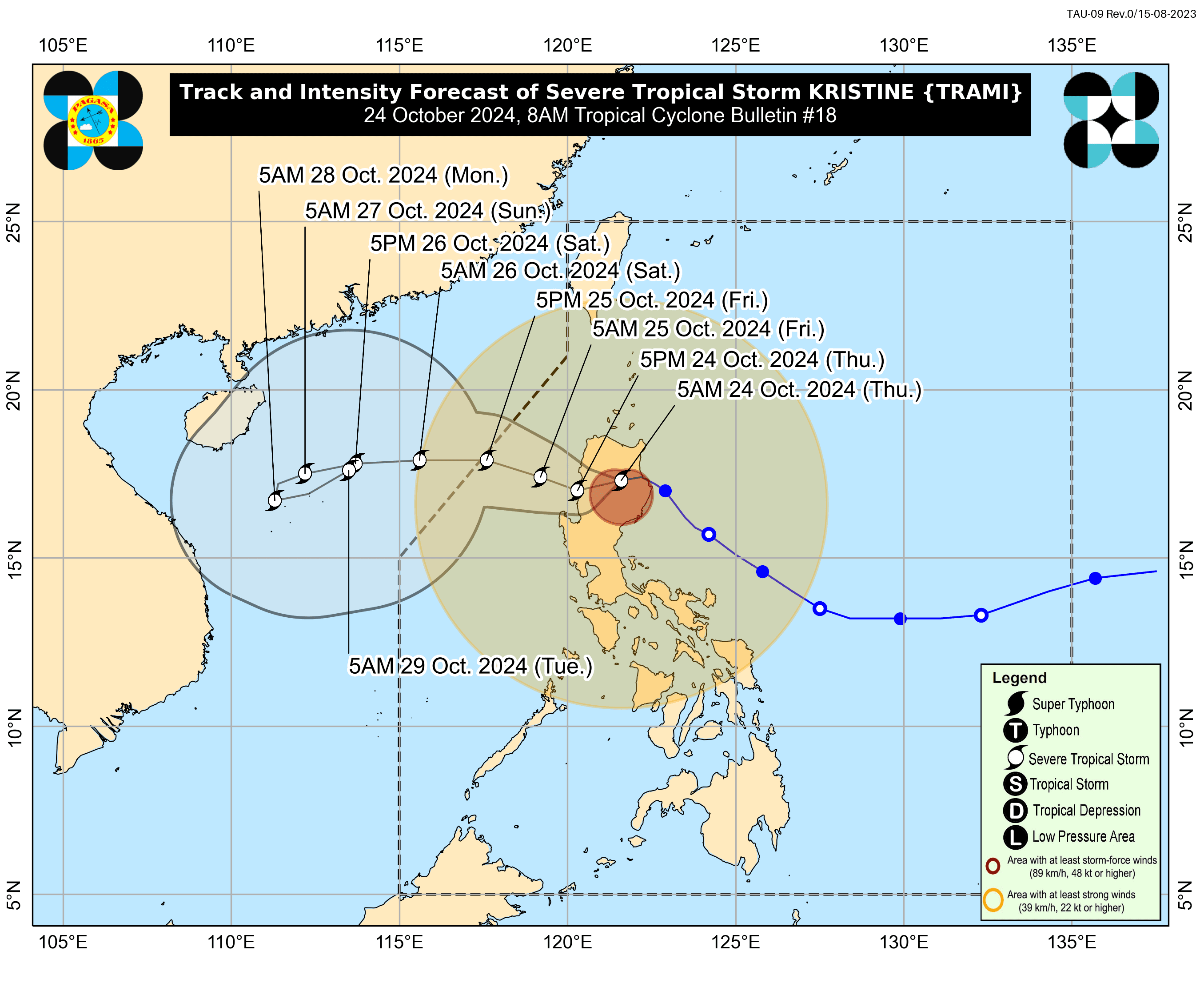
Severe Tropical Storm “Kristine” (international name “Trami”) began moving over the Cordillera Administrative Region (CAR) on Thursday morning, Oct. 24, after making landfall in Isabela, said the Philippine Atmospheric, Geophysical and Astronomical Services Administration (PAGASA).
Meanwhile, a low-pressure area (LPA) was monitored outside the Philippine Area of Responsibility (PAR) but has no direct effects yet on any part of the country.
In its 8 a.m. bulletin., PAGASA said Kristine was already in the vicinity of Aguinaldo, Ifugao, moving westward at 20 kilometers per hour (kph).
The severe tropical storm has maintained maximum sustained winds of 95 kph near its center and gusts reaching up to160 kph.
PAGASA said Kristine will continue to cross Northern Luzon over the next 12 hours and is expected to emerge over the waters west of Ilocos Region by Thursday afternoon.
PAGASA Weather Specialist Benison Estareja said that as of 5 a.m., Northern and Central Luzon may have already experienced peak strong winds and heavy rains from Kristine, as well as Southern Luzon due to the storm’s outer rainbands.
Wind signals
Estareja said Kristine has maintained a vast circulation with a diameter of about 1,400 to 1,500 kilometers that is continuously affecting Luzon and parts of the Visayas.
As of 8 a.m., Signal No. 3 is in effect in the southern portion of Cagayan (Peñablanca, Tuguegarao City, Enrile, Solana, Iguig, Tuao), Isabela, Quirino, Nueva Vizcaya, Kalinga, Mountain Province, Ifugao, southern portion of Abra (Malibcong, Licuan-Baay, Sallapadan, Daguioman, Bucloc, Boliney, Tubo, Luba, Manabo, Bucay, Villaviciosa, Pilar, San Isidro, Peñarrubia), Benguet, northern and central portions of Aurora (Dilasag, Casiguran, Dinalungan, Dipaculao, Maria Aurora, Baler), northern portion of Nueva Ecija (Carranglan, Lupao, San Jose City, Pantabangan, Guimba, Santo Domingo, Talavera, Llanera, Rizal, Bongabon, Talugtug, Science City of Muñoz, Cuyapo, Nampicuan), the northern portion of Tarlac (Mayantoc, San Clemente, Camiling, Santa Ignacia, Gerona, Paniqui, Moncada, San Manuel, Anao, Ramos, Pura, Victoria), northern portion of Zambales (Candelaria, Santa Cruz, Masinloc), Pangasinan, La Union, and central and southern portions of Ilocos Sur (Cervantes, Quirino, Sigay, Suyo, Alilem, Sugpon, Tagudin, Santa Cruz, Salcedo, Gregorio del Pilar, San Emilio, Lidlidda, Burgos, San Esteban, Santiago, Banayoyo, Galimuyod, City of Candon, Santa Lucia, Nagbukel, Santa Maria, Narvacan).
Signal No. 2 is still up in Metro Manila, Ilocos Norte, the rest of Ilocos Sur, Apayao, the rest of Abra, the rest of Cagayan (including Babuyan Islands), the rest of Aurora, the rest of Nueva Ecija, Bulacan, the rest of Tarlac, Pampanga, the rest of Zambales, Bataan, Cavite, Laguna, Rizal, Batangas, northern and central portions of Quezon (Lucena City, Pagbilao, Infanta, Tiaong, San Antonio, Candelaria, Lucban, Sampaloc, Sariaya, City of Tayabas, Mauban, Dolores, General Nakar, Real), including Polillo Islands, and Lubang Island.
Signal No. 1 also remains in effect in Batanes, the rest of Quezon, the rest of Occidental Mindoro, Oriental Mindoro, Marinduque, Romblon, northern portion of mainland Palawan (El Nido, Taytay, Araceli, San Vicente, Dumaran, Roxas), including Calamian Islands and Cuyo Islands, Camarines Norte, Camarines Sur, Catanduanes, Albay, Sorsogon, Masbate (including Ticao and Burias Islands), Aklan, Capiz, Antique (including Caluya Islands), Iloilo, Bantayan Islands, Northern Samar, northern portion of Samar (Calbayog City, Santo Nino, Almagro, Tagapul-An, San Jorge, Matuguinao, Jiabong, Pagsanghan, City of Catbalogan, Gandara, Motiong, San Jose de Buan, Santa Margarita, Tarangnan, Daram, Zumarraga), Biliran, northern portion of Eastern Samar (Maslog, Jipapad, Arteche, Oras, San Policarpo), and northwestern portion of Leyte (Calubian, San Isidro).
Rainfall forecast
PAGASA warned of continuous intense to torrential rainfall (over 200 millimeters) in Pangasinan, Zambales, and La Union.
Heavy to intense rainfall (100 to 200 millimeters) may persist in Cagayan Valley, CAR, the rest of Ilocos Region, Tarlac, Pampanga, Bataan, Cavite, Batangas, Calamian Islands, and Occidental Mindoro.
Meanwhile, moderate to heavy rainfall (50 to 100 millimeters) may continue to affect Metro Manila, Bulacan, Nueva Ecija, Aurora, Laguna, Rizal, Quezon, Oriental Mindoro, Marinduque, Romblon, Antique, Aklan, Negros Occidental, and Palawan.
The trough or extension of Kristine may also bring scattered rains and thunderstorms to Zamboanga Peninsula, Lanao del Norte, Lanao del Sur, Misamis Occidental, and the rest of Visayas, while the rest of Mindanao may experience isolated rain showers or thunderstorms.
The severe tropical storm may exit the PAR by Friday afternoon, Oct. 25.
However, Estareja said Kristine may slow down by Sunday or Monday, Oct. 27 or 28, and could recurve near southern China by Monday or Tuesday, Oct. 29.
He advised the public to continue to monitor the storm as it could still influence weather conditions along the western coast of the Philippines next week.
New LPA
Estareja said the LPA outside the PAR was located 2,365 kilometers east of northeastern Mindanao around 3 a.m.
There is a high chance it will develop into a tropical depression within the next 24 hours, he said.
While it remains far from the country in the coming days, monitoring will continue as it may enter the PAR early next week, he added.
The next tropical cyclone name on PAGASA’s list is “Leon.”