


 Philippines
National
'Kristine' may loop back toward West Philippine Sea after exiting PAR
Philippines
National
'Kristine' may loop back toward West Philippine Sea after exiting PAR
'Kristine' may loop back toward West Philippine Sea after exiting PAR
Brewing cyclone near PH may influence storm's track


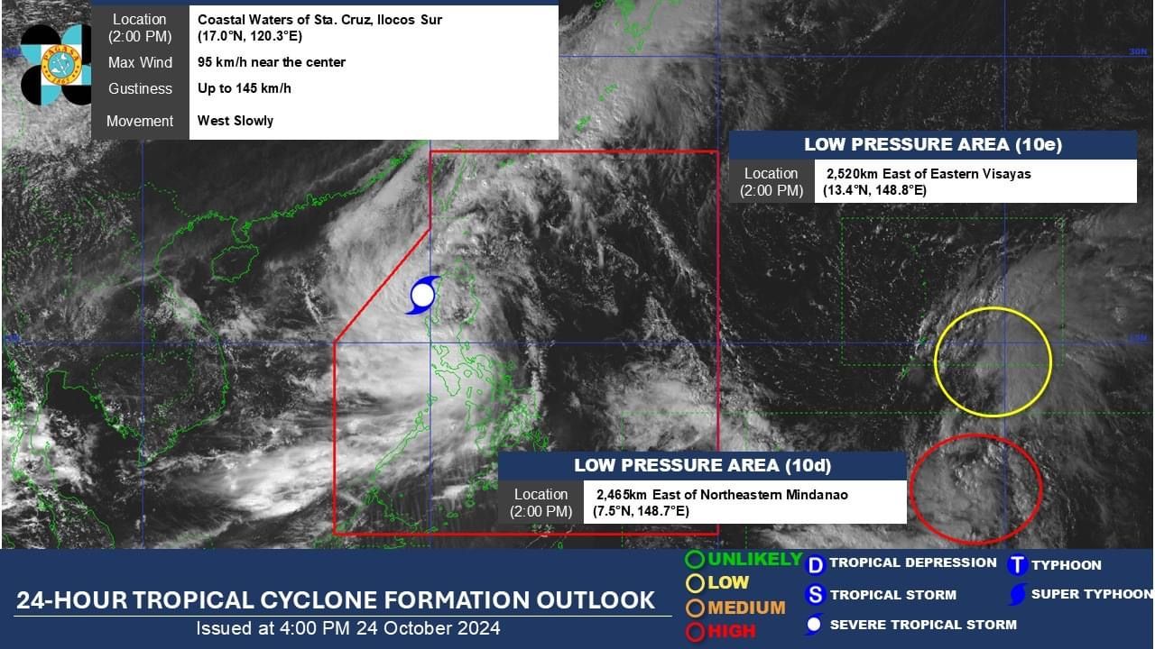
Severe Tropical Storm “Kristine” (international name “Trami”) is expected to exit the Philippine Area of Responsibility (PAR) by Friday afternoon, Oct. 25, after unleashing strong winds and heavy rains across the country.
As of 4 p.m. on Thursday, Oct. 24, the Philippine Atmospheric, Geophysical and Astronomical Services Administration (PAGASA) said the center of Kristine was over the coastal waters of Santa Lucia, Ilocos Sur.
The severe tropical storm has maintained maximum sustained winds of 95 kilometers per hour (kph) near the center and gusts reaching up to 115 kph while moving slowly westward.
A few days after exiting the PAR, PAGASA said there is a possibility that Kristine may loop back over the West Philippine Sea by Sunday or Monday, Oct. 27 or 28, which could result in its return to the PAR.
This scenario depends on the behavior of a low-pressure area (LPA) monitored east of Mindanao, which is likely to develop into a tropical depression within the next 24 hours.
PAGASA said the potential weather disturbance, located 2,465 kilometers east of northeastern Mindanao as of Thursday afternoon, may enter the PAR early next week. If it does, it will be named “Leon.”
Weather Specialist Veronica Torres said the LPA could either approach northern Luzon or recurve away from the country.
However, due to its distance, there is still significant uncertainty regarding its track, she added.
Wind signals
As of the 5 p.m. bulletin from PAGASA, Signal No. 3 is still in effect in Ilocos Sur, La Union, and Pangasinan due to Kristine.
Signal No. 2 remains in place in Cagayan (including Babuyan Islands), Isabela, Quirino, Nueva Vizcaya, Apayao, Kalinga, Abra, Ifugao, Mountain Province, Benguet, Ilocos Norte, Aurora, Nueva Ecija, Tarlac, Zambales, Bataan, Pampanga, and Bulacan.
Meanwhile, Signal No. 1 is still raised in Metro Manila, Batanes, Rizal, Batangas, Laguna, Cavite, Quezon, Occidental Mindoro, Oriental Mindoro, Marinduque, Romblon, northern portion of mainland Palawan (El Nido, Taytay, Araceli, San Vicente, Dumaran, Roxas, including Calamian Islands, Cuyo, and Kalayaan Islands), Camarines Norte, Camarines Sur, Catanduanes, Albay, Sorsogon, Masbate (including Ticao and Burias Islands), Aklan, Capiz, Antique (including Caluya Islands), Iloilo, Bantayan Islands, Northern Samar, and northern portion of Samar (Calbayog City, Almagro, Tagapul-An, Santo Nino).
Rainfall forecast
From Thursday evening to Friday afternoon, heavy to intense rainfall (100 to 200 millimeters) may continue in Pangasinan, Zambales, La Union, Cavite, Batangas, and Occidental Mindoro.
Meanwhile, moderate to heavy rainfall (50 to 100 millimeters) may occur across Cordillera Administrative Region, the rest of Ilocos Region, Tarlac, Pampanga, Bataan, Bulacan, Nueva Ecija, Aurora, Metro Manila, Laguna, Rizal, Quezon, Oriental Mindoro, Marinduque, Romblon, Antique, Aklan, Negros Occidental, and Palawan.
From Friday afternoon to Saturday afternoon, Oct. 26, heavy to intense rainfall may continue in Pangasinan, Zambales, and La Union, while moderate to heavy rainfall may persist in the rest of Ilocos Region, Bataan, Antique, Aklan, and Negros Occidental.
PAGASA warned that these conditions could lead to flooding and landslides, particularly in areas already vulnerable to previous rainfall.