ADVERTISEMENT

7 areas still under Signal No. 3 as 'Kristine' crosses Northern Luzon

Published Oct 24, 2024 04:46 am

At A Glance

  • Kristine is expected to leave the Luzon landmass and emerge over the waters west of Ilocos Region by Thursday afternoon. 
  • It will likely exit the Philippine Area of Responsibility (PAR) by Friday afternoon.
  • A low-pressure area east of northeastern Mindanao has a high chance of developing into a tropical depression within the next 24 hours. It may enter the PAR early next week.
IMG_4442.jpeg
Satellite image of Severe Tropical Storm Kristine (Trami) as of 10:40 a.m., Oct. 24, 2024 (Courtesy of PAGASA)

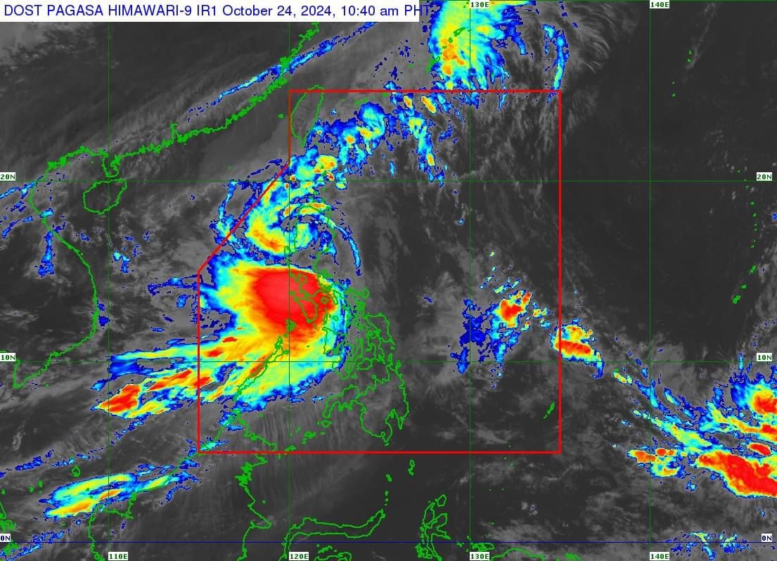
Tropical cyclone wind warnings remain in effect in several areas in Luzon and Visayas on Thursday, Oct. 24 as Severe Tropical Storm “Kristine” (international name “Trami”) traverses Northern Luzon.

In its 11 a.m. bulletin, PAGASA said that Kristine has maintained maximum sustained winds of 95 kilometers per hour (kph) near the center and gusts of up to 160 kph while moving west-southwestward over the Cordillera Administrative Region (CAR) at a speed of 20 kph.

As of 10 a.m., the center of the severe tropical storm was in Bauko, Mountain Province.

As Kristine’s effects continue, Signal No. 3 remains hoisted over Mountain Province, Ifugao, Benguet, northern portion of Nueva Vizcaya (Bayombong, Ambaguio, Bagabag, Villaverde, Kayapa, Bambang, Diadi, Quezon, Solano, Santa Fe, Aritao), southern portion of Ilocos Sur (Cervantes, Quirino, Sigay, Suyo, Alilem, Sugpon, Tagudin, Santa Cruz, Salcedo, Gregorio del Pilar, San Emilio, Lidlidda, Burgos, San Esteban, Santiago, Banayoyo, Galimuyod, City of Candon, Santa Lucia, Nagbukel, Santa Maria, Narvacan), La Union, and Pangasinan.

Signal No. 2 is up in Metro Manila, Cagayan including Babuyan Islands, Isabela, Quirino, the rest of Nueva Vizcaya, Apayao, Kalinga, Abra, Ilocos Norte, the rest of Ilocos Sur, Nueva Ecija, Aurora, Bulacan, Tarlac, Pampanga, Zambales, Bataan, Rizal, Cavite, western portion of Batangas (Lian, Nasugbu, Tuy, Calatagan, Balayan), northern portion of Quezon (Real, Infanta, General Nakar), including Polillo Islands, northern portion of Laguna (Cabuyao City, City of Santa Rosa, City of Bisan, City of San Pedro, Pakil, Mabitac, Pangil, Santa Maria, Siniloan, Famy), and Lubang Islands.

Signal No. 1 is also in effect in Batanes, the rest of Batangas, the rest of Laguna, the rest of Quezon, the rest of Occidental Mindoro, Oriental Mindoro, Marinduque, Romblon, northern portion of mainland Palawan (El Nido, Taytay, Araceli, San Vicente, Dumaran, Roxas, including Calamian Islands, Cuyo, and Kalayaan Islands), Camarines Norte, Camarines Sur, Catanduanes, Albay, Sorsogon, Masbate (including Ticao and Burias Islands), Aklan, Capiz, Antique (including Caluya Islands), Iloilo, Bantayan Islands, Northern Samar, northern portion of Samar (Calbayog City, Santo Nino, Almagro, Tagapul-An, San Jorge, Matuguinao, Jiabong, Pagsanghan, City of Catbalogan, Gandara, Motiong, San Jose de Buan, Santa Margarita, Tarangnan, Daram, Zumarraga), Biliran, northern portion of Eastern Samar (Maslog, Jipapad, Arteche, Oras, San Policarpo), and northwestern portion of Leyte (Calubian, San Isidro).

PAGASA warned that from Thursday noon to Friday noon, intense to torrential rainfall (over 200 millimeters) may persist in Pangasinan, Zambales, La Union, and Occidental Mindoro.

Heavy to intense rainfall (100 to 200 millimeters) is also expected to continue in Cagayan Valley, CAR, the rest of Ilocos Region, Tarlac, Pampanga, Bataan, Cavite, Batangas, and Calamian Islands.

Meanwhile, moderate to heavy rainfall (50 to 100 millimeters) may prevail over Metro Manila, Bulacan, Nueva Ecija, Aurora, Laguna, Rizal, Quezon, Oriental Mindoro, Marinduque, Romblon, Antique, Aklan, Negros Occidental, and Palawan.

From Friday noon to Saturday, Oct. 26, Pangasinan, Zambales, and La Union may continue to experience heavy to intense rainfall, while moderate to heavy rainfall may persist in the rest of Ilocos Region, CAR, and Bataan.

PAGASA warned that these rainy conditions could lead to flooding and landslides, particularly in areas identified as highly or very highly susceptible to these hazards and those with significant antecedent rainfall.

Kristine is expected to leave the Luzon landmass and emerge over the waters west of Ilocos Region by Thursday afternoon. It will likely exit the Philippine Area of Responsibility (PAR) by Friday afternoon.

In the 5 a.m. forecast, Weather Specialist Benison Estareja said the severe tropical storm may slow down by Sunday or Monday, Oct. 27 or 28, and could recurve before reaching southern China by Monday or Tuesday, Oct. 29.

He added that Kristine may still influence weather conditions along the western coast of the Philippines next week.

Meanwhile, Estareja said a low-pressure area (LPA) located 2,365 kilometers east of northeastern Mindanao around 3 a.m. has a high chance of developing into a tropical depression within the next 24 hours.

It may enter the PAR early next week, he added.

The next tropical cyclone name on PAGASA’s list is “Leon.”

Related Tags

low pressure area Signal No. 3 PAGASA Tropical Storm Kristine
ADVERTISEMENT
.most-popular .layout-ratio{ padding-bottom: 79.13%; } @media (min-width: 768px) and (max-width: 1024px) { .widget-title { font-size: 15px !important; } }

{{ articles_filter_1561_widget.title }}

.most-popular .layout-ratio{ padding-bottom: 79.13%; } @media (min-width: 768px) and (max-width: 1024px) { .widget-title { font-size: 15px !important; } }

{{ articles_filter_1562_widget.title }}

.most-popular .layout-ratio{ padding-bottom: 79.13%; } @media (min-width: 768px) and (max-width: 1024px) { .widget-title { font-size: 15px !important; } }

{{ articles_filter_1563_widget.title }}

{{ articles_filter_1564_widget.title }}

.mb-article-details { position: relative; } .mb-article-details .article-body-preview, .mb-article-details .article-body-summary{ font-size: 17px; line-height: 30px; font-family: "Libre Caslon Text", serif; color: #000; } .mb-article-details .article-body-preview iframe , .mb-article-details .article-body-summary iframe{ width: 100%; margin: auto; } .read-more-background { background: linear-gradient(180deg, color(display-p3 1.000 1.000 1.000 / 0) 13.75%, color(display-p3 1.000 1.000 1.000 / 0.8) 30.79%, color(display-p3 1.000 1.000 1.000) 72.5%); position: absolute; height: 200px; width: 100%; bottom: 0; display: flex; justify-content: center; align-items: center; padding: 0; } .read-more-background a{ color: #000; } .read-more-btn { padding: 17px 45px; font-family: Inter; font-weight: 700; font-size: 18px; line-height: 16px; text-align: center; vertical-align: middle; border: 1px solid black; background-color: white; } .hidden { display: none; }
function initializeAllSwipers() { // Get all hidden inputs with cms_article_id document.querySelectorAll('[id^="cms_article_id_"]').forEach(function (input) { const cmsArticleId = input.value; const articleSelector = '#article-' + cmsArticleId + ' .body_images'; const swiperElement = document.querySelector(articleSelector); if (swiperElement && !swiperElement.classList.contains('swiper-initialized')) { new Swiper(articleSelector, { loop: true, pagination: false, navigation: { nextEl: '#article-' + cmsArticleId + ' .swiper-button-next', prevEl: '#article-' + cmsArticleId + ' .swiper-button-prev', }, }); } }); } setTimeout(initializeAllSwipers, 3000); const intersectionObserver = new IntersectionObserver( (entries) => { entries.forEach((entry) => { if (entry.isIntersecting) { const newUrl = entry.target.getAttribute("data-url"); if (newUrl) { history.pushState(null, null, newUrl); let article = entry.target; // Extract metadata const author = article.querySelector('.author-section').textContent.replace('By', '').trim(); const section = article.querySelector('.section-info ').textContent.replace(' ', ' '); const title = article.querySelector('.article-title h1').textContent; // Parse URL for Chartbeat path format const parsedUrl = new URL(newUrl, window.location.origin); const cleanUrl = parsedUrl.host + parsedUrl.pathname; // Update Chartbeat configuration if (typeof window._sf_async_config !== 'undefined') { window._sf_async_config.path = cleanUrl; window._sf_async_config.sections = section; window._sf_async_config.authors = author; } // Track virtual page view with Chartbeat if (typeof pSUPERFLY !== 'undefined' && typeof pSUPERFLY.virtualPage === 'function') { try { pSUPERFLY.virtualPage({ path: cleanUrl, title: title, sections: section, authors: author }); } catch (error) { console.error('ping error', error); } } // Optional: Update document title if (title && title !== document.title) { document.title = title; } } } }); }, { threshold: 0.1 } ); function showArticleBody(button) { const article = button.closest("article"); const summary = article.querySelector(".article-body-summary"); const body = article.querySelector(".article-body-preview"); const readMoreSection = article.querySelector(".read-more-background"); // Hide summary and read-more section summary.style.display = "none"; readMoreSection.style.display = "none"; // Show the full article body body.classList.remove("hidden"); } document.addEventListener("DOMContentLoaded", () => { let loadCount = 0; // Track how many times articles are loaded const offset = [1, 2, 3, 4, 5, 6, 7, 8, 9, 10]; // Offset values const currentUrl = window.location.pathname.substring(1); let isLoading = false; // Prevent multiple calls if (!currentUrl) { console.log("Current URL is invalid."); return; } const sentinel = document.getElementById("load-more-sentinel"); if (!sentinel) { console.log("Sentinel element not found."); return; } function isSentinelVisible() { const rect = sentinel.getBoundingClientRect(); return ( rect.top < window.innerHeight && rect.bottom >= 0 ); } function onScroll() { if (isLoading) return; if (isSentinelVisible()) { if (loadCount >= offset.length) { console.log("Maximum load attempts reached."); window.removeEventListener("scroll", onScroll); return; } isLoading = true; const currentOffset = offset[loadCount]; window.loadMoreItems().then(() => { let article = document.querySelector('#widget_1690 > div:nth-last-of-type(2) article'); intersectionObserver.observe(article) loadCount++; }).catch(error => { console.error("Error loading more items:", error); }).finally(() => { isLoading = false; }); } } window.addEventListener("scroll", onScroll); });

Sign up by email to receive news.