


'Kristine' exits landmass; 4 provinces under Signal No. 3


At A Glance
- Kristine will likely exit the PAR by Friday afternoon, Oct. 25.
- PAGASA said the storm may loop over the West Philippine Sea from Sunday to Monday, Oct. 27 to 28, and move eastward or east-northwestward toward the PAR, depending on the behavior of a developing weather disturbance east of the PAR.
- The weather disturbance, which is currently a low-pressure area, is expected to develop into a tropical depression within the next 24 hours.
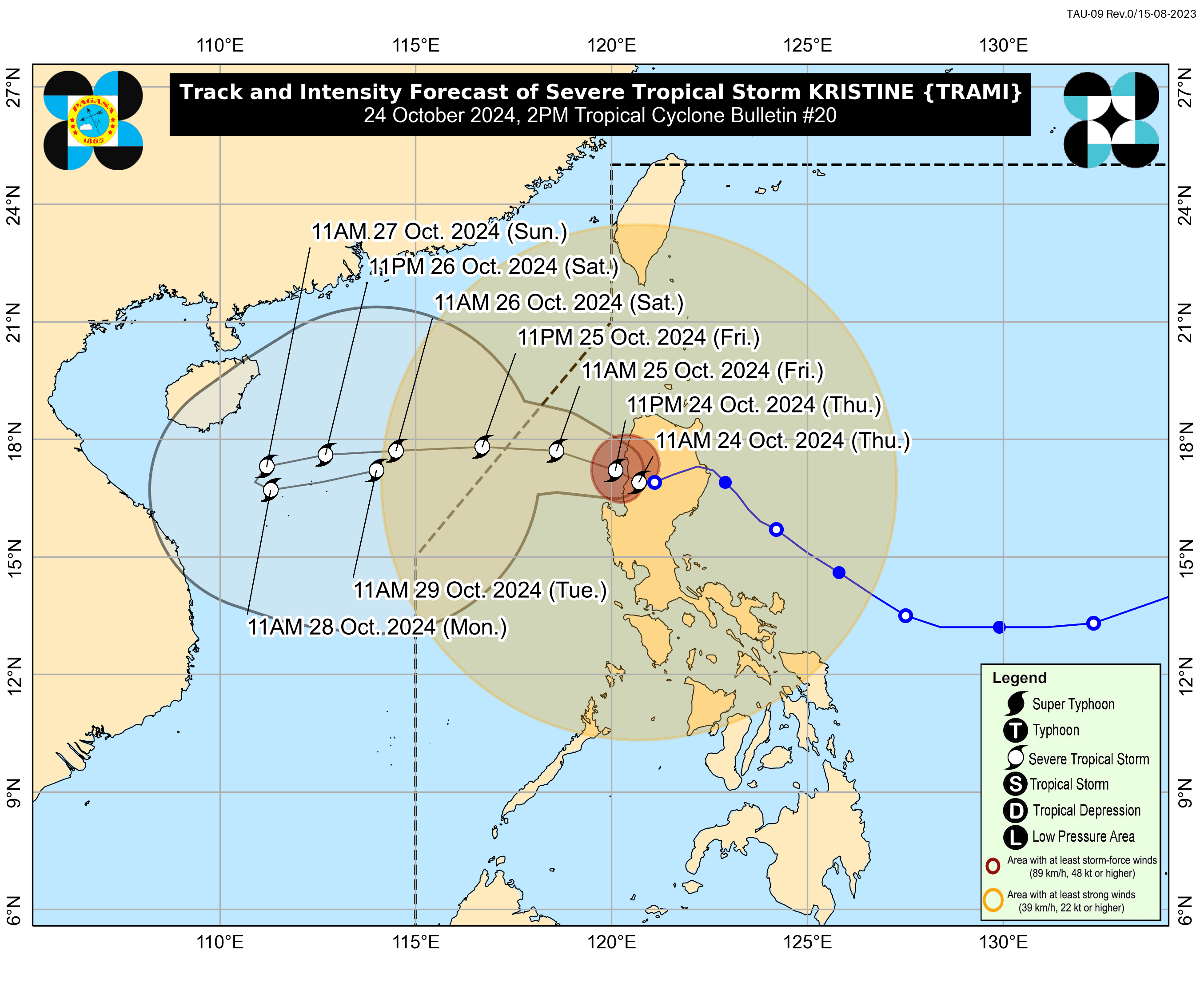
Severe Tropical Storm “Kristine” (international name “Trami”) exited the country via Ilocos Sur as it headed toward the West Philippine Sea on Thursday afternoon, Oct. 24, said the Philippine Atmospheric, Geophysical and Astronomical Services Administration (PAGASA).
Kristine made landfall in Divilacan, Isabela at 12:30 a.m. on Thursday and crossed the Cordillera Administrative Region (CAR) before exiting the landmass.
As of 2 p.m., the center of the severe tropical storm was over the coastal waters of Santa Cruz, Ilocos Sur. It maintained maximum sustained winds of 95 kilometers per hour (kph) near the center and gusts reaching up to 115 kph.
Despite its exit, the effects of Kristine are still being felt. Wind Signal No. 3 is still in effect in Benguet, Ilocos Sur, La Union, and Pangasinan.
Meanwhile, Signal No. 2 remains in place in Metro Manila, Batanes, Cagayan including Babuyan Islands, Isabela, Quirino, Nueva Vizcaya, Apayao, Kalinga, Abra, Ifugao, Mountain Province, Aurora, Nueva Ecija, Tarlac, Zambales, Bataan, Pampanga, Bulacan, Rizal, Cavite, western portion of Batangas (Nasugbu, Lian), northern portion of Quezon (General Nakar, Infanta, including Polillo Islands), and Lubang Islands.
Signal No. 1 is also up in Laguna, the rest of Batangas, the rest of Quezon, the rest of Occidental Mindoro, Oriental Mindoro, Marinduque, Romblon, northern portion of mainland Palawan (El Nido, Taytay, Araceli, San Vicente, Dumaran, Roxas, including Calamian Islands, Cuyo, and Kalayaan Islands), Camarines Norte, Camarines Sur, Catanduanes, Albay, Sorsogon, Masbate (including Ticao and Burias Islands), Aklan, Capiz, Antique (including Caluya Islands), Iloilo, Bantayan Islands, Northern Samar, and northern portion of Samar (Santa Margarita, Almagro, Tagapul-An, Calbayog City, Santo Nino, Gandara, Matuguinao).
From Thursday afternoon to Friday afternoon, Oct. 25, intense to torrential rainfall (over 200 millimeters) may persist in Pangasinan, Zambales, La Union, and Occidental Mindoro.
Heavy to intense rainfall (100 to 200 millimeters) may continue in Metro Manila, Cagayan Valley, CAR, the rest of Ilocos Region, Tarlac, Pampanga, Bataan, Cavite, Batangas, and Calamian Islands.
Meanwhile, moderate to heavy rainfall (50 to 100 millimeters) may prevail over Bulacan, Nueva Ecija, Aurora, Laguna, Rizal, Quezon, Oriental Mindoro, Marinduque, Romblon, Antique, Aklan, Negros Occidental, and Palawan.
From Friday afternoon to Saturday afternoon, Oct. 26, Pangasinan, Zambales, and La Union may continue to experience heavy to intense rainfall, while moderate to heavy rainfall may persist in the rest of Ilocos Region, CAR, and Bataan.
PAGASA warned that these conditions could lead to flooding and landslides, particularly in areas already vulnerable to previous rainfall.
Kristine will likely exit the Philippine Area of Responsibility (PAR) by Friday afternoon.
However, PAGASA said the storm may loop over the West Philippine Sea from Sunday to Monday, Oct. 27 to 28, and move eastward or east-northwestward towards the PAR, depending on the behavior of a developing weather disturbance east of the PAR.
The weather disturbance, which is currently a low-pressure area, is expected to develop into a tropical depression within the next 24 hours.
While Kristine is likely to remain a severe tropical storm over the next five days, there remains a possibility it could be upgraded to a typhoon, PAGASA said.