


 Philippines
National
59 areas placed under tropical cyclone wind signals due to 'Kristine'
Philippines
National
59 areas placed under tropical cyclone wind signals due to 'Kristine'
59 areas placed under tropical cyclone wind signals due to 'Kristine'


At A Glance
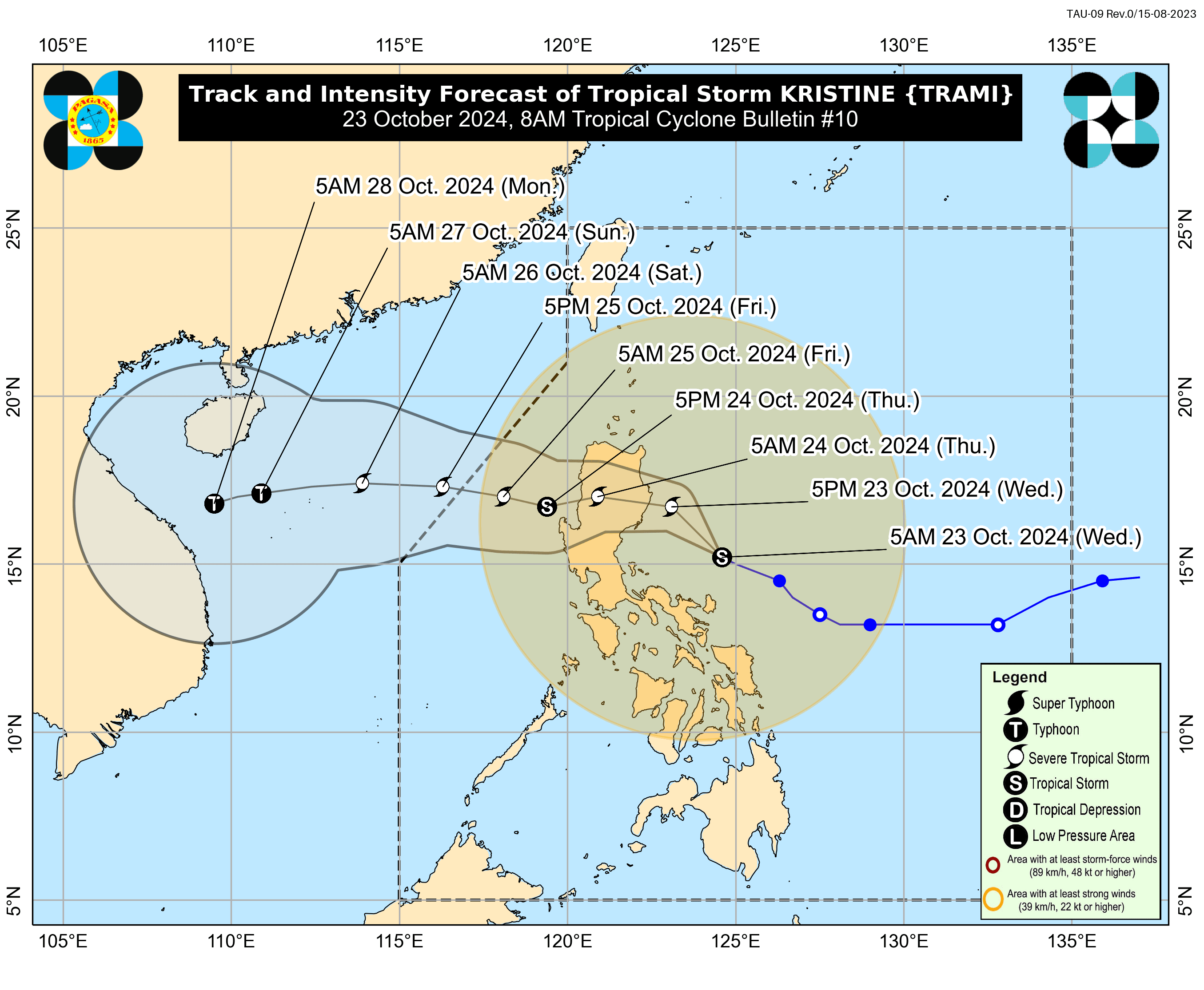
- Kristine could make landfall in Isabela or northern Aurora on Wednesday evening, Oct. 23, or Thursday morning, Oct. 24, potentially as a severe tropical storm.
- Nearly the entire country is expected to experience rainfall in the next 24 hours due to the vast circulation of Tropical Storm Kristine.
- Kristine may exit the Philippine Area of Responsibility on Friday, Oct. 25.
Twenty-six areas have been placed under tropical cyclone wind Signal No. 2 and 33 areas under Signal No. 1 as Tropical Storm “Kristine” (international name “Trami”) approaches Luzon on Wednesday, Oct. 23, said the Philippine Atmospheric, Geophysical and Astronomical Services Administration (PAGASA).
In the PAGASA’s 8 a.m. bulletin, Signal No. 2 was raised in Ilocos Norte, Ilocos Sur, La Union, Pangasinan, Apayao, Abra, Kalinga, Mountain Province, Ifugao, Benguet, mainland Cagayan, Isabela, Quirino, Nueva Vizcaya, Aurora, Nueva Ecija, Bulacan, Tarlac, Pampanga, Zambales, northern and eastern portions of Quezon (Infanta, General Nakar, Real, Mauban, Perez, Alabat, Quezon, Calauag, Tagkawayan, Guinayangan), including Polillo Islands, Camarines Norte, Camarines Sur, Catanduanes, Albay, and northeastern portion of Sorsogon (Prieto Diaz, City of Sorsogon).
Areas under Signal No. 1 include Metro Manila, Batanes, Babuyan Islands, Bataan, Rizal, Cavite, Laguna, Batangas, the rest of Quezon, Occidental Mindoro including Lubang Islands, Oriental Mindoro, Marinduque, Romblon, Calamian Islands, the rest of Sorsogon, Masbate (including Ticao and Burias Islands), Aklan, Capiz, Antique (including Caluya Islands), Iloilo, Guimaras, northern portion of Negros Occidental (Pontevedra, La Castellana, Moises Padilla, Bago City, La Carlota City, Valladolid, Pulupandan, Bacolod City, San Enrique, Murcia, Silay City, City of Talisay, Enrique B. Magalona, Manapla, City of Victorias, Cadiz City, Sagay City, City of Escalante, Toboso, Calatrava, Salvador Benedicto, San Carlos City), northern portion of Negros Oriental (Vallehermoso, Canlaon City, City of Guihulngan), northern and central portions of Cebu (Alcantara, Argao, Dumanjug, Sibonga, Pinamungahan, Ronda, Liloan, Cebu City, Moalboal, Consolacion, Danao City, Borbon, Carmen, Daanbantayan, Tuburan, City of Bogo, Tabogon, City of Naga, Lapu-Lapu City, City of Carcar, Mandaue City, Catmon, Minglanilla, Toledo City, Cordova, Compostela, San Remigio, Balamban, Aloguinsan, San Fernando, Asturias, Barili, Medellin, Sogod, Tabuelan, City of Talisay), including Bantayan Islands and Camotes Islands, Bohol, the rest of Eastern Samar, the rest of Northern Samar, Samar, Leyte, Biliran, Southern Leyte, Dinagat Islands, and Surigao del Norte (including Siargao-Bucas Grande Group).
Kristine has maximum sustained winds of 85 kilometers per hour (kph) near the center and gusts reaching up to 105 kph.
The storm’s center was located 310 kilometers east of Baler, Aurora, and is expected to move west-northwestward at 15 kph.
PAGASA said Kristine could make landfall in Isabela or northern Aurora on Wednesday evening, or Thursday morning, Oct. 24, potentially as a severe tropical storm.
Heavy rainfall forecast
Nearly the entire country is expected to experience rainfall in the next 24 hours due to the vast circulation of Tropical Storm Kristine.
PAGASA warned of intense to torrential rainfall in Ilocos Region, Cordillera Administrative Region, Central Luzon, Bicol Region, mainland Cagayan, Isabela, Quirino, Nueva Vizcaya, and Quezon.
Moderate to, at times, intense rainfall is also expected in Metro Manila, the rest of Luzon, Visayas, Dinagat Islands, and Surigao del Norte.
The trough or extension of Kristine may also bring moderate to, at times, heavy rains to Zamboanga Peninsula, Northern Mindanao, Bangsamoro Autonomous Region in Muslim Mindanao, and Soccsksargen.
The rest of Mindanao is likely to experience isolated rain showers or thunderstorms due to Kristine’s trough.
PAGASA warned that these conditions may lead to flooding and landslides, especially in areas identified as highly or very highly susceptible to these hazards on hazard maps, and in areas with significant antecedent rainfall.
Kristine may exit the Philippine Area of Responsibility on Friday, Oct. 25.