


Tropical cyclone Aghon tracker


12 noon, May 29
Typhoon “Aghon” (international name: Ewiniar) left the Philippine area of responsibility.
5 p.m., May 28
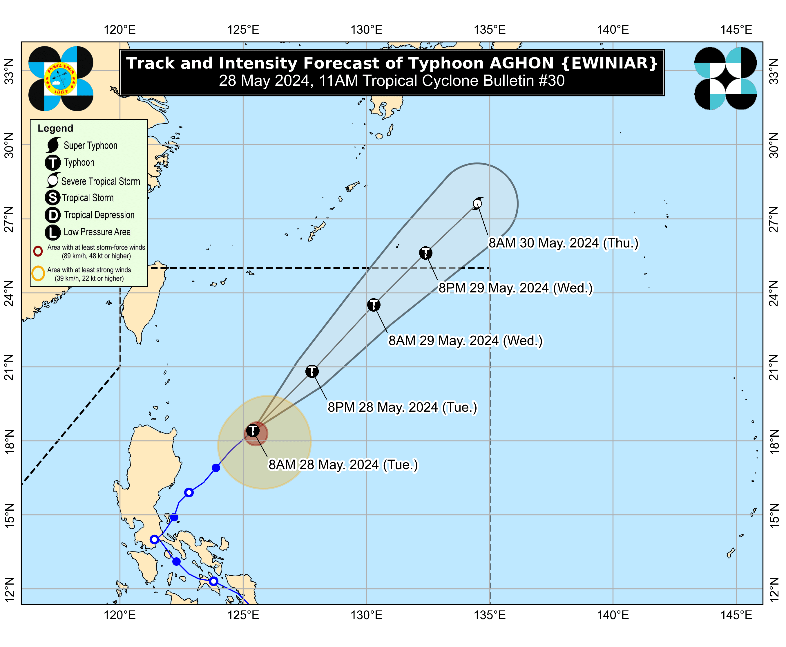
The center of the eye of Typhoon “Aghon” (international name: Ewiniar) was estimated 535 kilometers east of Basco, Batanes.
Aghon has no more direct effect on any part of the country, PAGASA said.
It is expected to continue to move northeastward over the Philippine Sea until it leaves the country’s area of responsibility by Wednesday afternoon, May 29.
5 a.m., May 28
The center of the eye of Typhoon “Aghon” (international name: Ewiniar) was estimated 335 kilometers east of Tuguegarao City, Cagayan.
As it moves away, PAGASA said no more areas are under tropical cyclone wind warnings as potential impacts from its severe winds are no longer expected.
It is expected to continue to move northeastward over the Philippine Sea until it leaves the country’s area of responsibility by Wednesday afternoon or evening, May 29.
11 p.m., May 27
The center of the eye of Typhoon Aghon was estimated 240 kilometers east-northeast of Casiguran, Aurora.
The typhoon is moving at a northeastward direction at a speed of 15 kilometers per hour.
It is still expected to exit the country’s area of responsibility by Wednesday afternoon or evening, May 29.
5 p.m., May 27
Typhoon Aghon was last located 155 kilometers east of Casiguran, Aurora and maintained its maximum sustained winds of 140 kilometers per hour (kph) near the center and gusts of up to 170 kph.
It is expected to move at a northeastward direction over the Philippine Sea until it leaves the country’s area of responsibility on Wednesday afternoon or evening, May 29.
11 a.m., May 27
The center of the eye of Typhoon Aghon was located 100 kilometers east-southeast of Casiguran, Aurora.
The typhoon is moving northeastward at 10 kilometers per hour.
It is expected to exit the Philippine area of responsibility on Wednesday afternoon or evening, May 29.
8 a.m., May 27
The center of the eye of Typhoon Aghon was located over the coastal waters of Casiguran, Aurora.
The typhoon is moving north-northeastward at 10 kilometers per hour.
It is still expected to exit the Philippine area of responsibility by Wednesday, May 29.
5 a.m., May 27
PAGASA estimated the location of the center of the eye of Typhoon “Aghon” 105 kilometers east of Baler, Aurora, at 5 a.m., moving in a north-northwestward direction at a speed of 10 kilometers per hour (kph).
It has slightly intensified with maximum sustained winds of 140 kph near the center and gusts of up to 170 kph.
Aghon is expected to exit the country’s area of responsibility by Wednesday, May 29.
2 a.m., May 27
The center of the eye of Typhoon “Aghon” was estimated 90 kilometers east-southeast of Baler, Aurora.
It is moving north-northeastward at 10 kilometers per hour.
11 p.m., May 26
PAGASA said Aghon was located over the coastal waters of Burdeos, Quezon, moving in a northeastward direction at a speed of 15 kph.
It has been lingering over Quezon province since 4 a.m. on Sunday.
As it continues to linger over Quezon province, tropical cyclone Aghon rapidly intensified into a typhoon on Sunday evening.
8 p.m., May 26
Severe tropical storm Aghon (international name: Ewiniar) made another landfall over Patnanungan, Quezon.
It was moving northeastward slowly while maintaining its maximum sustained winds of 100 kilometers per hour (kph) near the center and gusts of up to 150 kph.
5 p.m., May 26
The PAGASA said on Sunday, May 26, that "Aghon" has intensified into a Severe Tropical Storm (STS) while moving over the coastal waters of Mauban, Quezon.
In a 5 p.m. weather update, PAGASA located STS Aghon, internationally known as "Ewiniar," over the coastal waters of Mauban, Quezon, moving northeastward "slowly."
At 4 p.m., "Aghon" had maximum sustained winds of 95 kilometers per hour (kph) and gusts of up to 130 kph.
2 p.m., May 26
Tropical Storm "Aghon" is slowly moving northwestward and is currently “in the vicinity of Mauban, Quezon.”
Over the next 12 hours, PAGASA said Aghon will traverse mainland Quezon and Polillo Islands.
By Sunday evening, it is projected to be located over the waters off the east coast of Quezon province.
11 a.m., May 26
The Philippine Atmospheric, Geophysical and Astronomical Services Administration (PAGASA) located the center of tropical storm Aghon “in the vicinity of Sariaya, Quezon,” moving at a northwestward direction at a speed of 10 kph.
From 65 kilometers per hour (kph) maximum sustained winds and 90 kph of gusts, Aghon now has maximum sustained winds of 75 kph and gusts of up to 125 kph.
8 a.m., May 26
The center of tropical storm “Aghon” was near Dolores, Quezon, moving in a northwestward direction at a speed of 15 kilometers per hour (kph).
It is expected to move across the landmass of mainland Calabarzon (Cavite, Laguna, Batangas, Rizal, Quezon) and Polillo Islands within the next 12 hours, and over the waters off the east coast of Quezon or Aurora by Sunday evening or early Monday morning.
5 a.m., May 26
The center of Aghon was over the coastal waters of Lucena City, Quezon as of 4 a.m., moving in a northwestward direction at a speed of 10 kilometers per hour (kph).
Based on its track forecast, PAGASA anticipates Aghon to make landfall in Quezon province within the next three hours.
Weather Specialist Daniel James Villamil said the tropical cyclone has already made landfall seven times—in Homonhon Island and Giporlos in Eastern Samar (11:20 p.m., May 24 and 12:40 a.m., May 25, respectively); Basiao and Cagduyong Island in Catbalogan, Samar (4 a.m. and 5 a.m., May 25, respectively); Batuan and Masbate City in Masbate province (10:20 a.m. and 10:45 a.m., May 25, respectively); and Torrijos, Marinduque (10 p.m., May 25).
2 a.m., May 26
The center of Aghon was located “in the vicinity of Santa Cruz, Marinduque,” moving in a north-northwestward direction at a speed of 10 kilometers per hour (kph), while maintaining maximum sustained winds of 55 kph near the center and gusts of up to 90 kph.
Based on its track forecast, PAGASA anticipates Aghon to move northwestward or north-northwestward and make another landfall in mainland Quezon within the next 12 hours.
The tropical cyclone has already made landfall seven times—in Homonhon Island and Giporlos in Eastern Samar; Basiao and Cagduyong Island in Catbalogan, Samar; Batuan and Masbate City in Masbate province; and Torrijos, Marinduque.
11 p.m., May 25
Tropical Depression Aghon slightly intensified as it made its seventh landfall over Torrijos, Marinduque, the PAGASA said on Saturday, May 25.
In the 11 p.m. bulletin, PAGASA said TD Aghon's maximum sustained winds had slightly increased to 55 kilometers per hour (kph) near the center, up from 45 kph in the 7 p.m. monitoring.
At 10 p.m., PAGASA sighted the location of "Aghon" over the vicinity of Torrijos, Marinduque, moving northwestward at 15 kph with gusts of up to 75 kph.
8 p.m., May 25
The center of the eye of Tropical Depression Aghon is over the coastal waters of San Francisco, Quezon.
At 8 p.m., it maintained its maximum sustained winds of 45 kilometers per hour (kph) near the center and gusts of up to 70 kph.
From Marinduque, where it was forecasted to make landfall within the next 12 hours, it may continue making another landfall over Batangas or Quezon before traversing the Cavite, Laguna, Batangas, Rizal, and Quezon (CALABARZON) area.
5 p.m., May 25
Stormy weather conditions over parts of Luzon, including Metro Manila, are expected in the next 24 hours due to Tropical Depression Aghon, said the PAGASA on Saturday, May 25.
At 4 p.m., PAGASA monitored the location of "Aghon" over the coastal waters of Sibuyan Island, maintaining its maximum sustained winds of 45 kilometers per hour (kph) near the center and gusts of up to 70 kph.
Based on its bulletin, "Aghon" was moving west-northwestward at 20 kph.
2 p.m., May 25
Tropical Depression Aghon slightly weakened after its sixth landfall over Masbate City.
As of 2 p.m., Aghon” has maximum sustained winds of 45 to 155 kilometers per hour (kph) near the center and gusts of up to 70 kph.
While moving west-northwestward over Sibuyan Sea and Tayabas Bay, it may make landfall over Marinduque within the next 12 hours.
11 a.m., May 25
Tropical Depression Aghon might make landfall on Ticao Island, making it the fifth landfall location.
As of 11 a.m., Aghon is currently over the coastal waters of San Vicente, Northern Samar.
It is forecasted that "Aghon" will continue to move over the coastal waters of Burias Island between this afternoon and evening.
8 a.m., May 25
Tropical Depression Aghon continues to move over the coastal waters of Calbayog City, Samar.
As of 7 a.m., "Aghon" has maintained its maximum sustained winds of 55 kilometers per hour (kph) near the center and gusts of up to 85 kph.
Its center was located over the coastal waters of Calbayog City, Samar, moving northwestward at 30 kph.
5 a.m., May 25
Tropical Depression Aghon maintains its strength over the coastal waters of Catbalogan City, Samar.
As of 4 a.m., "Aghon" has maintained its maximum sustained winds of 55 kilometers per hour (kph) near the center and gusts of up to 90 kph.
Its center was located over the coastal waters of Catbalogan City, Samar, moving northwestward at 30 kph.
2 a.m., May 25
Tropical depression Aghon made landfall over Giporlos, Eastern Samar.
In the next few hours, Aghon is expected to traverse Samar Island and emerge over the Samar Sea-San Bernardino Strait area.
It will then continue northwestward, crossing the Bicol Peninsula between Saturday afternoon and Sunday early morning, May 26.
11 p.m., May 24
Tropical depression Aghon was located 145 kilometers east of Surigao City, Surigao del Norte, moving northwest at 20 kilometers per hour (kph).
PAGASA said Aghon will continue to move northwestward and is expected to make landfall as a tropical depression near Eastern Samar in the next 12 hours, most likely by Saturday early morning, May 25.
However, due to the westward shift in the track forecast, there is an increasing possibility of landfall in the vicinity of Leyte and/or Dinagat Islands within the next 12 hours.
Aghon has maintained its maximum sustained winds of 55 kph near the center and gusts of up to 70 kph.
8 p.m., May 24
PAGASA said "Aghon" continues to move west-northwestward over the sea east of Mindanao.
The center of the tropical depression was located 145 km east of Surigao City, Surigao del Norte, moving northwestward at 20 kilometers per hour (kph).
Aghon has maintained its maximum sustained winds of 55 kilometers per hour (kph) near the center and gusts of up to 70 kph.
5 p.m., May 24
The center of tropical depression “Aghon” was located 135 kilometers (km) northeast of Hinatuan, Surigao del Sur or 185 km east-southeast of Surigao City, Surigao del Norte, moving west-northwest at 30 kilometers per hour (kph).
It is expected to cross Eastern Samar or Dinagat Islands on Saturday morning, before moving over Samar Island or Northern Samar on Saturday afternoon.
Aghon has maintained its maximum sustained winds of 55 kilometers per hour (kph) near the center and gusts of up to 70 kph, but it may intensify into a tropical storm before its landfall.
2 p.m., May 24
Based on its track forecast, PAGASA said Aghon is still expected to make a “close approach or landfall” over Eastern Visayas on Saturday morning, May 25.
As of 1 p.m., the center of tropical depression Aghon was located 135 kilometers east-northeast of Hinatuan, Surigao del Sur, moving west-northwestward at 25 kilometers per hour (kph).
It has slightly intensified with maximum sustained winds of 55 kph near the center and gusts of up to 70 kph.
11 a.m., May 24
As of 10 a.m., the center of tropical depression Aghon was located 240 kilometers east of Hinatuan, Surigao del Sur, moving west-northwestward at 10 kilometers per hour (kph).
It has maintained its maximum sustained winds of 45 kph near the center and gusts of up to 55 kph.
Based on its track forecast, PAGASA said Aghon may make a “close approach or landfall” over Eastern Visayas on Saturday morning, May 25.
5 a.m., May 24
The Philippine Atmospheric, Geophysical and Astronomical Services Administration (PAGASA) said Aghon was located 340 kilometers east of Hinatuan, Surigao del Sur, moving west-northwestward at 30 kilometers per hour (kph).
It has maximum sustained winds of 45 kph near the center and gusts of up to 55 kph.
Based on its track forecast, PAGASA said Aghon may “make a close approach or make landfall” over Eastern Samar on Saturday morning, May 25, while remaining a tropical depression.
2 a.m., May 24
The low pressure area (LPA) east of Mindanao developed into a tropical depression at 2 a.m. on Friday, May 24, and was given the name “Aghon,” the Philippines’ first tropical cyclone for 2024.