


Tropical cyclone Goring tracker


11 p.m., Aug. 30
Super typhoon Goring (international name: Saola) left the country’s area of responsibility Wednesday evening, Aug. 30, prompting the lifting of all tropical cyclone wind signals in Northern Luzon.
PAGASA last located the center of the eye of Goring 265 kilometers west of Itbayat, Batanes.
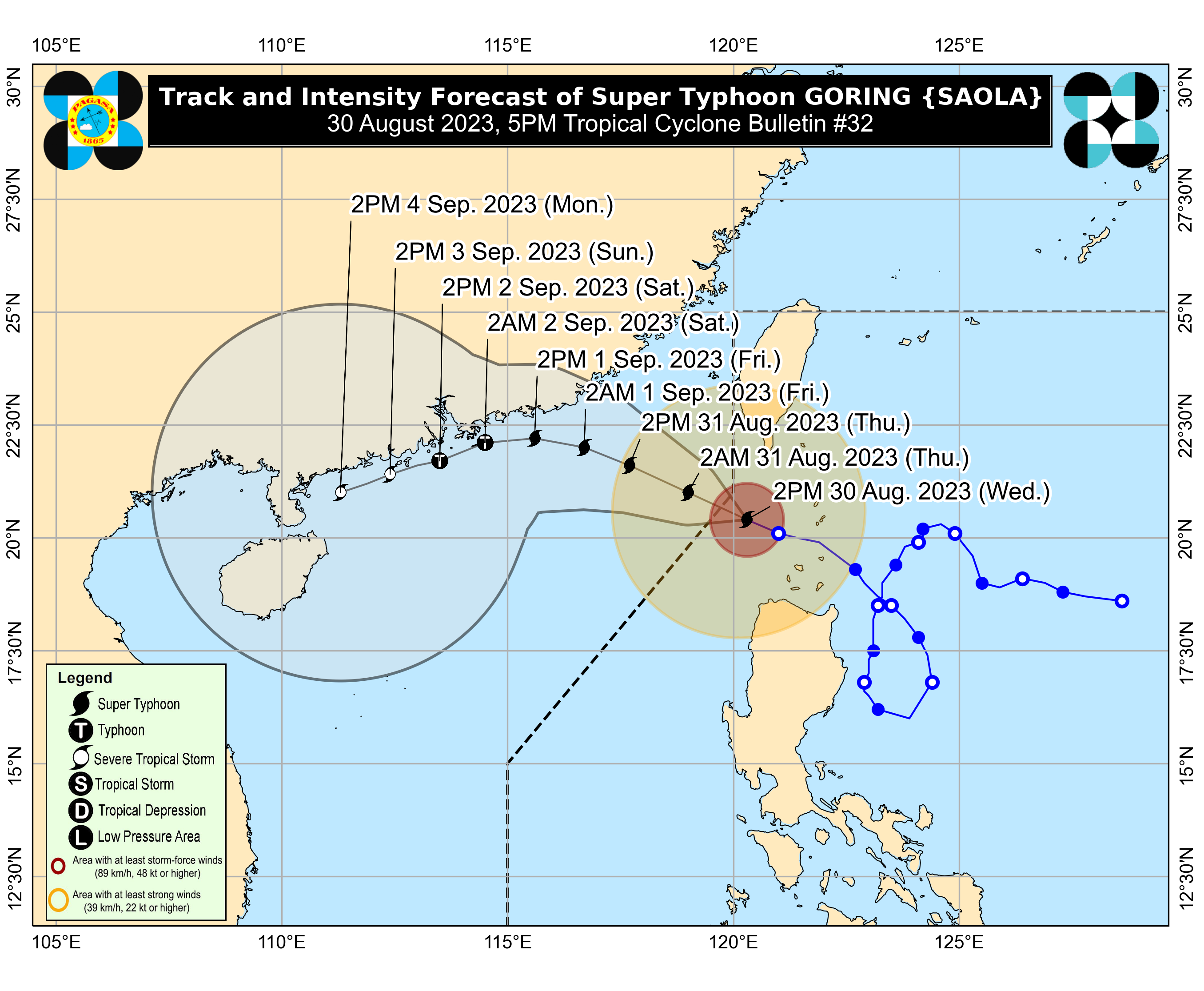
5 p.m., Aug. 30
PAGASA last located Goring 185 kilometers west of Itbayat, Batanes.
It is moving west-northwestward at 15 kilometers per hour (kph) with maximum sustained winds of 195 kph near the center and gusts of up to 240 kph.
Goring may leave the Philippine area of responsibility Wednesday evening, Aug. 30 or Thursday morning, Aug. 31.
11 a.m., Aug. 30
PAGASA said Goring was last spotted 125 kilometers west-southwest of Basco, Batanes, and was moving west-northwest at a speed of 15 kilometers per hour (kph) toward the West Philippine Sea.
It may leave the country’s area of responsibility by Wednesday evening or Thursday morning.
8 a.m., Aug. 30
PAGASA said the center of the eye of Goring was last located 90 kilometers west-southwest of Basco, Batanes.
The super typhoon is currently moving west-northwestward at 15 kilometers per hour (kph), with maximum sustained winds of 195 kph near the center and gusts of up to 240 kph.
PAGASA said Goring may leave the Philippine area of responsibility Wednesday evening or Thursday morning, Aug. 31.
5 a.m., Aug. 30
Super typhoon Goring was last located over the coastal waters of Sabtang, Batanes.
It was moving northwestward at 20 kilometers per hour.
2 a.m., Aug. 30
PAGASA said super typhoon Goring was last spotted over the coastal waters of Calayan, Babuyan Island, Cagayan, moving northwestward at 15 kph.
It may continue to move northwestward or west-northwestward over the Luzon Strait until it leaves the Philippine area of responsibility (PAR) Wednesday evening or Thursday morning, Aug. 31.
“The latest track forecast indicates that the super typhoon will pass over the Balintang Channel in the next six hours, close to Babuyan Island and Batan-Sabtang Islands. The super typhoon will be passing through the region at or near its peak intensity,” PAGASA said.
11 p.m., Aug. 29
“Goring” re-intensified into a super typhoon, with maximum sustained winds of 185 kilometers per hour (kph) near the center and gusts of up to 230 kph.
It is moving northwestward at 10 kph, and was last spotted over the coastal waters of Calayan, Babuyan Island, Cagayan.
PAGASA said Goring may pass very close or make landfall in the vicinity of Babuyan Island in Cagayan province and Batan-Sabtang Islands in Batanes between Tuesday evening, Aug. 29 and Wednesday afternoon, Aug. 30
8 p.m., Aug. 29
PAGASA said Goring was spotted 140 kilometers east of Calayan, Cagayan, moving northwestward at 10 kilometers per hour (kph).
“The latest track forecast indicates that the typhoon may pass very close or make landfall in the vicinity of Babuyan Island tonight (Aug. 29) or tomorrow early morning (Aug. 30),” PAGASA said.
However, it noted that a slight northward shift in the track forecast may bring the eye and eyewall region of Goring to the southern portion of Batanes.
5 p.m., Aug. 29
Typhoon Goring is currently moving west-northwestward at 10 kph, and was last spotted 165 kilometers east of Calayan, Cagayan.
PAGASA said Goring will cross the Luzon Strait as it moves northwestward or west-northwestward from Tuesday until it leaves the Philippine area of responsibility (PAR) on Wednesday evening or Thursday morning, Aug. 30 or 31.
The typhoon may pass very close or make landfall in the vicinity of Babuyan Islands between Tuesday evening and early Wednesday morning, it pointed out.
However, a slight northward shift in the track forecast may bring the eye and eyewall region of Goring to the southern portion of Batanes, it added.
2 p.m., Aug. 29
The center of the eye of typhoon Goring was last located 175 kilometers east-northeast of Aparri, Cagayan or 190 kilometers east-southeast of Calayan, Cagayan.
It is still expected to pass very close or make landfall in the vicinity of Batanes between Wednesday morning and afternoon, Aug. 30.
However, a slight southward shift in the track forecast may bring the eye and eyewall region of Goring to the northern portion of Babuyan Islands, PAGASA pointed out.
11 a.m., Aug. 29
PAGASA said the center of the eye of typhoon Goring was located 180 kilometers east of Aparri, Cagayan.
It is moving northwestward slowly while maintaining maximum sustained winds of 155 kilometers per hour (kph) near the center and gusts of up to 190 kph.
The typhoon may pass very close or make landfall in the vicinity of Batanes between Wednesday morning and afternoon, Aug. 30.
However, a slight southward shift in the track forecast may bring the eye and eyewall region of Goring to the northern portion of Babuyan Islands, PAGASA pointed out.
5 a.m., Aug. 29
The Philippine Atmospheric, Geophysical and Astronomical Services Administration (PAGASA) projected that typhoon Goring (international name: Saola) may pass very close or make landfall in the vicinity of Batanes by Wednesday, Aug. 30.
However, PAGASA noted that a slight shift in the typhoon’s track forecast may bring the eye and eyewall of Goring to the northern part of Babuyan Islands.
The center of the eye of Goring was last located 220 kilometers east of Aparri, Cagayan.
11 p.m., Aug. 28
PAGASA said the center of the eye of typhoon Goring was last located 240 kilometers east of Tuguegarao City, Cagayan.
It has maintained its maximum sustained winds of 155 kilometers per hour (kph) near the center and gusts of up to 190 kph, while moving north-northwestward at 10 kph.
Based on the latest forecast track, the typhoon may make a close approach or landfall in the vicinity of Batanes Wednesday morning or afternoon, Aug. 30.
5 p.m., Aug. 28
The center of the eye of typhoon Goring was last located 260 kilometers east of Tuguegarao City, Cagayan.
Based on the latest forecast track, the typhoon will make a close approach to Batanes between Wednesday morning and evening, Aug. 30, with a landfall scenario not ruled out, before moving to the southern portion of Taiwan between Wednesday evening and Thursday morning, Aug. 31.
It may exit the Philippine area of responsibility (PAR) by Thursday morning or afternoon.
11 a.m., Aug. 28
Typhoon Goring continues to weaken but maintained its typhoon strength.
It has maximum sustained winds of 155 kilometers per hour (kph) near the center and gusts of up to 190 kph.
It was last spotted 245 kilometers east-northeast of Casiguran, Aurora, moving north-northeastward at 15 kph.
5 a.m., Aug. 28
Typhoon Goring was last seen 210 kilometers east of Casiguran, Aurora, moving east-southeastward at 15 kilometers per hour (kph).
PAGASA said that due to its looping track, Goring may continue to move northeastward and northward, then northwestward on Tuesday, Aug. 29 towards the Bashi Channel and the vicinity of Batanes.
Based on the latest forecast track, the typhoon will make a close approach to Batanes between Wednesday morning and evening, Aug. 30, with a possible landfall scenario not ruled out, before moving to the southern portion of Taiwan between Wednesday evening and Thursday morning, Aug. 31.
Goring was downgraded into a typhoon, packing maximum sustained winds of 175 kph near the center and gusts of up to 215 kph.
11 p.m., Aug. 27
The state weather bureau lowered the wind signal for the eastern portion of Isabela to TCWS No. 2, marking the last area under Signal No. 3.
At 11 p.m. PAGASA's update, 'Goring' has maximum sustained winds of 185 kilometers per hour (kph) near the center and gustiness of up to 230 kph.
The super typhoon was spotted 125 km east of Casiguran, Aurora, while moving at 10 kph.
PAGASA also forecasts that STY Goring will exit the Philippine Area of Responsibility (PAR) between the afternoon or evening of Thursday, Aug. 31.
5 p.m. Aug. 27
PAGASA said super typhoon Goring maintained its maximum sustained winds of 185 kilometers per hour (kph) near the center and gustiness of up to 230 kph.
The super typhoon was spotted 95 kilometers (km) east of Casiguran, Aurora, and was moving "slowly" in a southeastward direction.
2 p.m., Aug. 27
Super Typhoon Goring has maintained its strength while moving southward to the east-northeast of Casiguran, Aurora on Sunday, Aug. 27
"Goring" has maximum sustained winds of 185 kilometers per hour (kph) near the center and gustiness of up to 230 kph.
It continues to move "slowly" and was spotted 90 kilometers (km) east northeast of Casiguran, Aurora.
11 a.m. Aug. 27
As of Sunday morning, STY Goring has maximum sustained winds of 185 kilometers per hour (kph) near the center and gustiness of up to 230 kph.
PAGASA said it continues to move south-southwestward and was last located 95 kilometers (km) east-northeast of Casiguran, Aurora.
5 a.m., Aug. 27
"Goring" intensified into super typhoon (STY) on Sunday, Aug. 27
STY Goring was spotted over the coastal waters of Palanan, Isabela while moving south southwestward "slowly."
PAGASA said "Goring" has now maximum sustained winds of 185 kilometers per hour (kph) and gustiness of up to 230 kph.
11 p.m., Aug. 26
As per the latest report at 11 p.m., PAGASA said "Goring" has maximum sustained winds of 175 kilometers per hour (kph) near the center, and gustiness of up to 215 kph.
Meanwhile, PAGASA monitored the center eye of the typhoon 135 kilometers (km) east-southeast of Tuguegarao City, Cagayan, while moving at 10 kilometers per hour (kph).
5 p.m., Aug. 26
PAGASA said Goring was last spotted 145 kilometers (km) East Northeast of Tuguegarao City, Cagayan.
It has maximum sustained winds of 155 kilometers per hour (kph) and gusts up to 190 kph.
11 a.m., Aug. 26
PAGASA said "Goring" has maintained its strength as it continues to move northeastern, eastern of Luzon.
Typhoon Goring was spotted 155 kilometers (km) East of Aparri, Cagayan, traveling at 10 kilometers per hour (kph).
It has a maximum sustained winds of 150 kph near the center and gustiness of up to 185 kph.
5 a.m. Aug. 26
PAGASA spotted Typhoon Goring 185 kilometers (km) east-northeast of Aparri, Cagayan.
It was moving at 10 kilometers per hour (kph) southwestward with maximum sustained winds of 140 kph and gustiness of up to 170 kph near the center.
11 p.m., Aug. 25
PAGASA said “Goring” turned into a typhoon on Friday evening, only a few hours after it became a severe tropical storm.
It has maximum sustained winds of 120 kilometers per hour (kph) near the center and gusts of up to 150 kph, up from 110 kph winds and 135 kph gusts on Friday afternoon.
Goring was moving south-southwestward at 10 kph and was last located 205 kilometers (km) east of Calayan, Cagayan.
Signal No. 2 was raised over the northeastern portion of mainland Cagayan.
5 p.m., Aug. 25
Tropical cyclone Goring (international name: Saola) continues to intensify, reaching severe tropical storm status on Friday afternoon.
PAGASA said Goring has maximum sustained winds of 110 kilometers per hour (kph) near the center and gusts of up to 135 kph.
It also continues to move slowly southeastward and was last located 260 kilometers (km) east of Calayan, Cagayan.
11 a.m., Aug. 25
Tropical storm Goring (international name: Saola) continues to move slowly south-southwestward and was last located 225 km east-southeast of Basco, Batanes or 270 km east of Calayan, Cagayan.
It further intensified packing maximum sustained winds of 85 kph near the center and gusts of up to 105 kph.
Signal No. 1 was hoisted over Batanes and the eastern portions of Babuyan Islands, mainland Cagayan, and Isabela due to the anticipated strong winds from Goring.
5 a.m., Aug. 25
Tropical storm Goring continues to move slowly southwestward and was last located 220 kilometers (km) east-southeast of Basco, Batanes.
It has maximum sustained winds of 75 kph near the center and gusts of up to 90 kph.
Signal No. 1 was hoisted over Batanes, the eastern portion of Babuyan Islands, eastern portion of mainland Cagayan, and northeastern portion of Isabela due to the anticipated strong winds from Goring.
11 p.m., Aug. 24
Tropical storm Goring (international name: Saola) is slowly moving westward and was last seen 235 kilometers (km) east of Basco, Batanes.
It has maximum sustained winds of 65 kilometers per hour (kph) near the center and gusts of up to 80 kph.
Signal No. 1 was raised over Santa Ana, Cagayan in anticipation of Goring’s strong winds.
5 p.m., Aug. 24
Cyclone Goring (international name: Saola) has intensified into a tropical storm Thursday afternoon, Aug. 24, said the Philippine Atmospheric, Geophysical and Astronomical Services Administration (PAGASA).
In its 5 p.m. bulletin, PAGASA said Goring was last located 265 kilometers (km) east of Basco, Batanes.
It is moving northwestward at 10 kilometers per hour (kph), while packing maximum sustained winds of 75 kph near the center and gusts of up to 90 kph.
11 a.m., Aug. 24
PAGASA said Goring was last located 355 kilometers (km) east-northeast of Calayan, Cagayan or 300 km east of Basco, Batanes.
It is moving north-northwestward at 15 kilometers per hour (kph) with maximum sustained winds of 55 kph near the center and gusts of up to 70 kph.
5 a.m., Aug. 24
PAGASA said the low-pressure area (LPA) spotted near Cagayan province has intensified into a tropical depression and was named “Goring.”
It was last located 400 kilometers (km) east-northeast of Aparri, Cagayan, or 405 km east of Calayan, Cagayan.
It has maximum sustained winds of 55 kilometers per hour (kph) near the center and gusts of up to 70 kph as it moves slowly west-northwestward.
Goring is the country’s seventh tropical cyclone this year and the first in August.