


 Philippines
National
Signal No. 5 raised as 'Goring' re-intensifies into super typhoon
Philippines
National
Signal No. 5 raised as 'Goring' re-intensifies into super typhoon
Signal No. 5 raised as 'Goring' re-intensifies into super typhoon


At A Glance
- PAGASA said Goring may pass very close or make landfall in the vicinity of Babuyan Island in Cagayan province and Batan-Sabtang Islands in Batanes between Tuesday evening, Aug. 29 and Wednesday afternoon, Aug. 30.
- Heavy rains due to Goring and the southwest monsoon, or "habagat" may prevail over parts of the country in the next few days.
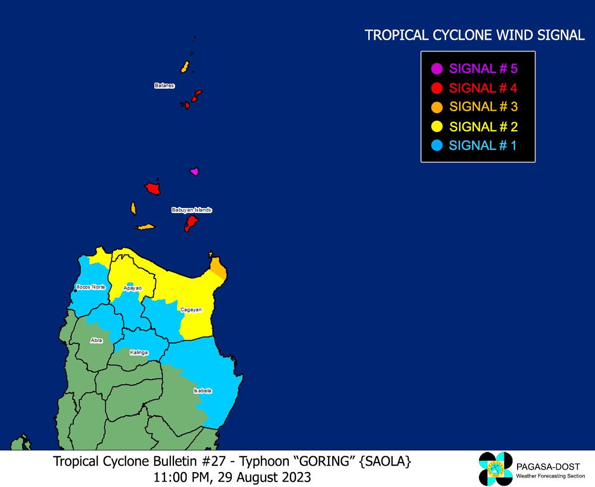
Tropical cyclone wind signal number 5 was raised over the northeastern part of Babuyan Islands as “Goring” (international name: Saola) re-intensified into a super typhoon on Tuesday evening, Aug. 29.
“Violent [and] life-threatening conditions now prevail over portions of Babuyan Islands as Goring intensifies into a super typhoon,” PAGASA said in its 11 p.m. bulletin.
Signal No. 4 was also hoisted over the southern portion of Batanes and the northwestern and southeastern portions of Babuyan Islands.
Signal No. 3 was also in effect in the rest of Batanes, the rest of Babuyan Islands, and the extreme northeastern portion of mainland Cagayan; Signal No. 2 in the northern and eastern portions of mainland Cagayan, northern portion of Ilocos Norte, and the northern portion of Apayao; and Signal No. 1 in the northern and eastern portions of Isabela, the rest of Ilocos Norte, the rest of Cagayan, the rest of Apayao, northern portion of Abra, and the northern portion of Kalinga.
As of 10 p.m., super typhoon Goring has maximum sustained winds of 185 kilometers per hour (kph) near the center and gusts of up to 230 kph.
It is currently moving northwestward at 10 kph, and was last spotted over the coastal waters of Calayan, Babuyan Island, Cagayan.
Landfall possible
PAGASA said Goring may pass very close or make landfall in the vicinity of Babuyan Island in Cagayan province and Batan-Sabtang Islands in Batanes between Tuesday evening and Wednesday afternoon, Aug. 30.
“Regardless of landfall or close approach point, Goring will bring typhoon-force conditions over most of Batanes and Babuyan Islands between tonight (Aug. 29) and tomorrow afternoon (Aug. 30). The super typhoon will be passing through the region at or near its peak intensity,” it pointed out.
“Goring is forecast to follow a mainly northwestward or west-northwestward path across the Luzon Strait from today (Aug. 29) until it exits the Philippine area of responsibility (PAR) tomorrow evening (Aug. 30) or on Thursday morning (Aug. 31),” it added.
Heavy rains
PAGASA said heavy rains due to Goring and the southwest monsoon, or “habagat” may continue to affect parts of the country in the next few days.
Until Wednesday evening, Babuyan Islands and Batanes may experience torrential rains (more than 200 millimeters), while Ilocos Norte, the northern portion of Apayao, and northwestern portion of mainland Cagayan may receive intense rains (100-200 millimeters).
Meanwhile, heavy rains (50-100 millimeters) may affect the northeastern portion of mainland Cagayan, Abra, Ilocos Sur, and the rest of Apayao.
The enhanced habagat may also bring occasional or monsoon rains over the western portions of Central and Southern Luzon and Visayas over the next three days.
“Under these conditions, flooding and rain-induced landslides are expected especially in areas that are highly or very highly susceptible to these hazards as identified in hazard maps and in localities that experienced considerable amounts of rainfall for the past several days,” PAGASA said.