ADVERTISEMENT

Signal No. 3 raised over parts of Batanes, Babuyan Islands as 'Goring' moves closer to extreme Northern Luzon

Published Aug 29, 2023 03:32 am
IMG_3209.jpeg
(PAGASA)

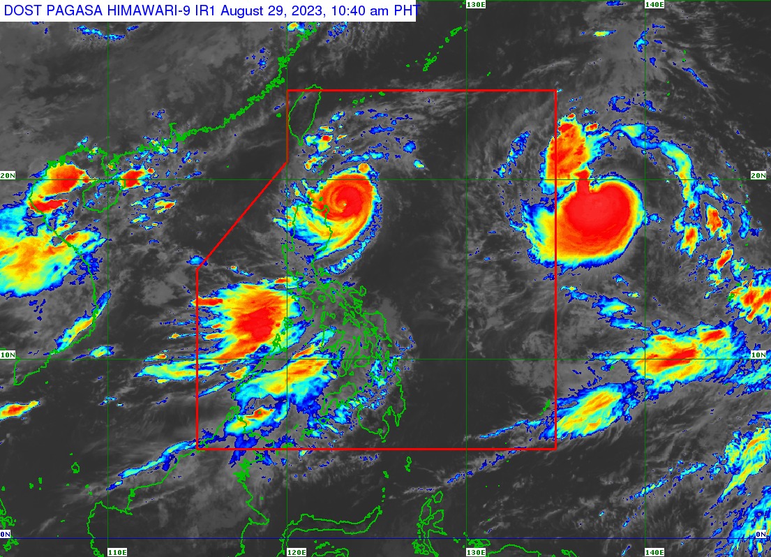
The Philippine Atmospheric, Geophysical, and Astronomical Services Administration (PAGASA) raised tropical cyclone wind signal number 3 over the southern portion of Batanes and the northeastern portion of Babuyan Islands on Tuesday, Aug. 29, as typhoon Goring (international name: Saola) moved closer to extreme Northern Luzon.

Signal No. 2 was also raised over the rest of Batanes and Babuyan Islands, and the extreme northeastern portion of mainland Cagayan, while Signal No. 1 was hoisted over the northern and eastern portions of mainland Cagayan, eastern portion of Isabela, northern portion of Apayao, and the northern portion of Ilocos Norte.

In its 11 a.m. bulletin, PAGASA said the center of the eye of typhoon Goring was located 180 kilometers east of Aparri, Cagayan.

It is moving northwestward slowly while maintaining maximum sustained winds of 155 kilometers per hour (kph) near the center and gusts of up to 190 kph.

PAGASA said that Goring may bring heavy to torrential rains to some areas of Cagayan Valley, Cordillera Administrative Region, and Ilocos Region over the next two days.

Likewise, the southwest monsoon, or “habagat,” enhanced by Goring may bring heavy rains over the western parts of Central and Southern Luzon and Visayas over the next three days.

READ MORE: https://mb.com.ph/2023/8/29/goring-may-pass-very-close-or-make-landfall-in-batanes-on-aug-30-pagasa

Landfall possible

PAGASA said Goring will cross the Luzon Strait as it moves northwestward or west-northwestward from Tuesday until it leaves the Philippine area of responsibility (PAR) on Wednesday evening or Thursday morning, Aug. 30 or 31.

The typhoon may pass very close or make landfall in the vicinity of Batanes between Wednesday morning and afternoon, PAGASA pointed out.

However, a slight southward shift in the track forecast may bring the eye and eyewall region of Goring to the northern portion of Babuyan Islands, it added.

“During this period, the typhoon is forecast to persist in strength by the time it passes very close or over Batanes, although gradual re-intensifying and reaching into a super typhoon category is not ruled out,” PAGASA said.

Related Tags

Super Typhoon Goring
ADVERTISEMENT
.most-popular .layout-ratio{ padding-bottom: 79.13%; } @media (min-width: 768px) and (max-width: 1024px) { .widget-title { font-size: 15px !important; } }

{{ articles_filter_1561_widget.title }}

.most-popular .layout-ratio{ padding-bottom: 79.13%; } @media (min-width: 768px) and (max-width: 1024px) { .widget-title { font-size: 15px !important; } }

{{ articles_filter_1562_widget.title }}

.most-popular .layout-ratio{ padding-bottom: 79.13%; } @media (min-width: 768px) and (max-width: 1024px) { .widget-title { font-size: 15px !important; } }

{{ articles_filter_1563_widget.title }}

{{ articles_filter_1564_widget.title }}

.mb-article-details { position: relative; } .mb-article-details .article-body-preview, .mb-article-details .article-body-summary{ font-size: 17px; line-height: 30px; font-family: "Libre Caslon Text", serif; color: #000; } .mb-article-details .article-body-preview iframe , .mb-article-details .article-body-summary iframe{ width: 100%; margin: auto; } .read-more-background { background: linear-gradient(180deg, color(display-p3 1.000 1.000 1.000 / 0) 13.75%, color(display-p3 1.000 1.000 1.000 / 0.8) 30.79%, color(display-p3 1.000 1.000 1.000) 72.5%); position: absolute; height: 200px; width: 100%; bottom: 0; display: flex; justify-content: center; align-items: center; padding: 0; } .read-more-background a{ color: #000; } .read-more-btn { padding: 17px 45px; font-family: Inter; font-weight: 700; font-size: 18px; line-height: 16px; text-align: center; vertical-align: middle; border: 1px solid black; background-color: white; } .hidden { display: none; }
function initializeAllSwipers() { // Get all hidden inputs with cms_article_id document.querySelectorAll('[id^="cms_article_id_"]').forEach(function (input) { const cmsArticleId = input.value; const articleSelector = '#article-' + cmsArticleId + ' .body_images'; const swiperElement = document.querySelector(articleSelector); if (swiperElement && !swiperElement.classList.contains('swiper-initialized')) { new Swiper(articleSelector, { loop: true, pagination: false, navigation: { nextEl: '#article-' + cmsArticleId + ' .swiper-button-next', prevEl: '#article-' + cmsArticleId + ' .swiper-button-prev', }, }); } }); } setTimeout(initializeAllSwipers, 3000); const intersectionObserver = new IntersectionObserver( (entries) => { entries.forEach((entry) => { if (entry.isIntersecting) { const newUrl = entry.target.getAttribute("data-url"); if (newUrl) { history.pushState(null, null, newUrl); let article = entry.target; // Extract metadata const author = article.querySelector('.author-section').textContent.replace('By', '').trim(); const section = article.querySelector('.section-info ').textContent.replace(' ', ' '); const title = article.querySelector('.article-title h1').textContent; // Parse URL for Chartbeat path format const parsedUrl = new URL(newUrl, window.location.origin); const cleanUrl = parsedUrl.host + parsedUrl.pathname; // Update Chartbeat configuration if (typeof window._sf_async_config !== 'undefined') { window._sf_async_config.path = cleanUrl; window._sf_async_config.sections = section; window._sf_async_config.authors = author; } // Track virtual page view with Chartbeat if (typeof pSUPERFLY !== 'undefined' && typeof pSUPERFLY.virtualPage === 'function') { try { pSUPERFLY.virtualPage({ path: cleanUrl, title: title, sections: section, authors: author }); } catch (error) { console.error('ping error', error); } } // Optional: Update document title if (title && title !== document.title) { document.title = title; } } } }); }, { threshold: 0.1 } ); function showArticleBody(button) { const article = button.closest("article"); const summary = article.querySelector(".article-body-summary"); const body = article.querySelector(".article-body-preview"); const readMoreSection = article.querySelector(".read-more-background"); // Hide summary and read-more section summary.style.display = "none"; readMoreSection.style.display = "none"; // Show the full article body body.classList.remove("hidden"); } document.addEventListener("DOMContentLoaded", () => { let loadCount = 0; // Track how many times articles are loaded const offset = [1, 2, 3, 4, 5, 6, 7, 8, 9, 10]; // Offset values const currentUrl = window.location.pathname.substring(1); let isLoading = false; // Prevent multiple calls if (!currentUrl) { console.log("Current URL is invalid."); return; } const sentinel = document.getElementById("load-more-sentinel"); if (!sentinel) { console.log("Sentinel element not found."); return; } function isSentinelVisible() { const rect = sentinel.getBoundingClientRect(); return ( rect.top < window.innerHeight && rect.bottom >= 0 ); } function onScroll() { if (isLoading) return; if (isSentinelVisible()) { if (loadCount >= offset.length) { console.log("Maximum load attempts reached."); window.removeEventListener("scroll", onScroll); return; } isLoading = true; const currentOffset = offset[loadCount]; window.loadMoreItems().then(() => { let article = document.querySelector('#widget_1690 > div:nth-last-of-type(2) article'); intersectionObserver.observe(article) loadCount++; }).catch(error => { console.error("Error loading more items:", error); }).finally(() => { isLoading = false; }); } } window.addEventListener("scroll", onScroll); });

Sign up by email to receive news.