


 Philippines
National
'Goring' may pass very close or make landfall in Batanes by Aug. 30 — PAGASA
Philippines
National
'Goring' may pass very close or make landfall in Batanes by Aug. 30 — PAGASA
'Goring' may pass very close or make landfall in Batanes by Aug. 30 — PAGASA
Signal No. 3 up


At A Glance
- Due to the anticipated strong winds from Goring, PAGASA once again raised tropical cyclone wind signal number 3 over the northeastern portion of Babuyan Islands.
- The highest possible warning that may be hoisted over extreme Northern Luzon is Signal No. 4.
- Meanwhile, the tropical storm with the international name "Haikui" may enter the PAR on Wednesday, Aug. 30.
- The new tropical storm will be given a local name "Hanna" once inside the PAR.
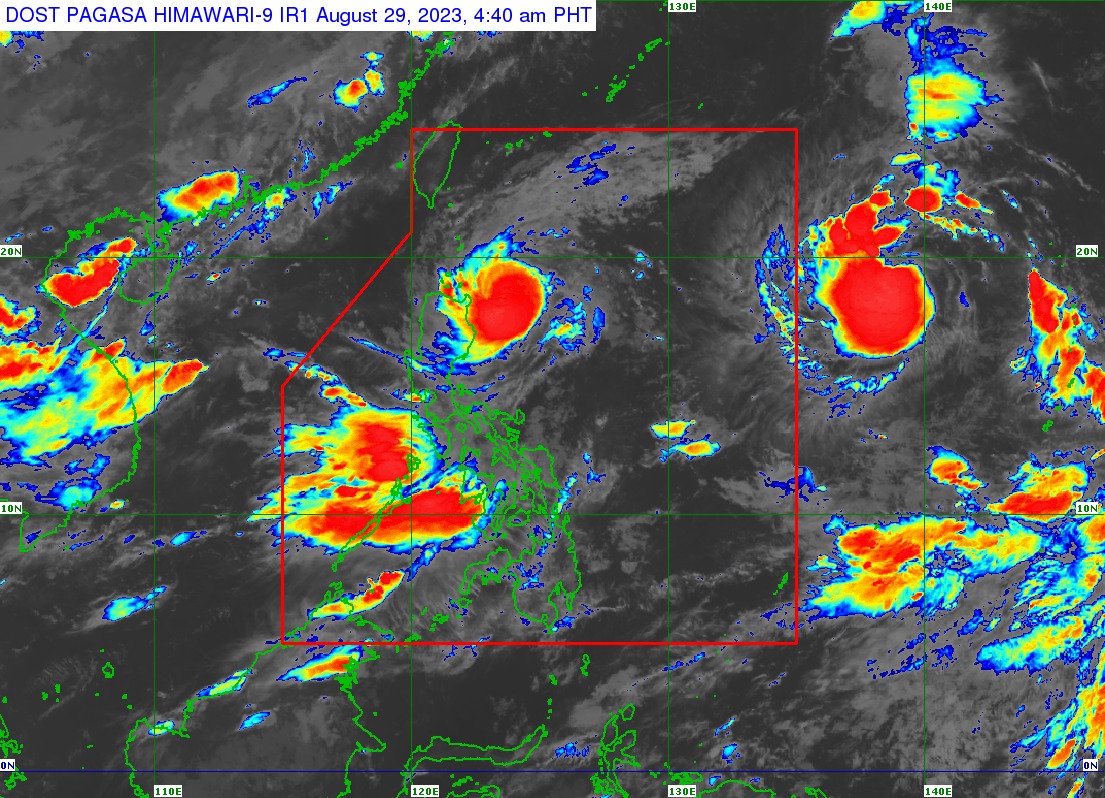
The Philippine Atmospheric, Geophysical and Astronomical Services Administration (PAGASA) on Tuesday, Aug. 29 projected that typhoon Goring (international name: Saola) may pass very close or make landfall in the vicinity of Batanes by Wednesday, Aug. 30.
However, PAGASA noted that a slight shift in the typhoon’s track forecast may bring the eye and eyewall of Goring to the northern part of Babuyan Islands.
As of 5 a.m., Tuesday, the center of the eye of Goring was located 220 kilometers east of Aparri, Cagayan.
It has maintained its maximum sustained winds of 155 kilometers per hour (kph) near the center and gusts of up to 190 kph, while moving north-northwestward at 10 kph.
Wind warnings still in effect
Due to the anticipated strong winds from Goring, PAGASA once again raised tropical cyclone wind signal number 3 over the northeastern portion of Babuyan Islands.
Meanwhile, Batanes, the rest of Babuyan Islands, and the extreme northeastern portion of mainland Cagayan are under Signal No. 2, while the northern and eastern portions of mainland Cagayan, eastern portion of Isabela, and the northern portions of Apayao and Ilocos Norte are under Signal No. 1.
PAGASA said Goring may re-intensify and peak at a near-super typhoon strength by the time it passes very close or over Batanes.
The highest possible warning that may be hoisted over extreme Northern Luzon is Signal No. 4.
Heavy rains to persist
On Tuesday, Goring may continue to bring intense rains (100-200 millimeters) to the northeastern part of Babuyan Islands, and heavy rains (50-100 millimeters) over Batanes, Babuyan Islands, Ilocos Norte, the northern portions of Abra and Apayao, and the northern and eastern portions of mainland Cagayan.
By Wednesday, Batanes and Babuyan Islands may experience torrential rains (more than 200 millimeters), while the northern portion of Ilocos Norte and the northwestern portion of Cagayan may receive intense rains.
Heavy rains may also affect Apayao, Abra, the northern portion of Ilocos Sur, northeastern portion of mainland Cagayan, and the rest of Ilocos Norte.
The southwest monsoon, or “habagat” enhanced by Goring may also bring heavy rains to Occidental Mindoro, Zambales, Bataan, Cavite, Batangas, the northern portion of Palawan, including Calamian and Cuyo Islands, Antique, the southwestern portion of Iloilo, and the northwestern portion of Aklan on Tuesday.
By Wednesday, heavy monsoon rains may prevail over Occidental Mindoro, Zambales, Bataan, Cavite, Batangas, the northern portion of Palawan, including Calamian and Cuyo Islands, Oriental Mindoro, and Antique.
By Thursday, heavy rains may affect Zambales, Bataan, Occidental Mindoro, Metro Manila, Rizal, Bulacan, Cavite, Batangas, and Pangasinan.
Goring may leave the Philippine area of responsibility (PAR) by Thursday, Aug. 31.
Tropical storm ‘Haikui’
Meanwhile, the tropical storm with the international name “Haikui” remains outside the PAR as of Tuesday morning.
Haikui was last spotted 1,885 kilometers east of Northern Luzon, moving westward at 20 kph.
It has maximum sustained winds of 65 kph near the center and gusts of up to 80 kph.
The tropical storm will be given a local name “Hanna” once inside the PAR by Wednesday.
“Haikui is forecast to steadily intensify over the next five days. It may reach severe tropical storm category within 48 hours—either prior or after entering PAR—and become a typhoon over the northeastern PAR region,” PAGASA said.
“The current forecast scenario suggests that Haikui is less likely to directly affect the country. However, it may enhance the southwest monsoon beginning on Wednesday or Thursday. This may result in the continuation of occasional or monsoon rains over the western portion of Luzon and Visayas throughout this week,” it added.