


 Philippines
National
'Habagat' enhanced by STY Goring to bring occasional heavy rains over Metro Manila, parts of Luzon
Philippines
National
'Habagat' enhanced by STY Goring to bring occasional heavy rains over Metro Manila, parts of Luzon
'Habagat' enhanced by STY Goring to bring occasional heavy rains over Metro Manila, parts of Luzon


At A Glance
- Due to "habagat" enhanced by Super Typhoon Goring, PAGASA said light to moderate with occasional heavy rains may be expected over Metro Manila, Rizal, Quezon, and Cavite as well as in Tarlac, Nueva Ecija, Zambales, Bataan, Pampanga, Bulacan, Laguna, and Batangas.
- In its latest bulletin, PAGASA said STY Goring continues to "maintain its strength" as it moves southward east northeast of Casiguran, Aurora.
Metro Manila and its neighboring provinces—Rizal, Quezon, and Cavite—can anticipate “light to moderate rains with occasional heavy rains” on Sunday, Aug. 27, due to the southwest monsoon or “habagat,” intensified by Super Typhoon Goring (international name: Saola).
In an advisory issued by the Philippine Atmospheric, Geophysical and Astronomical Services Administration (PAGASA) at 2:20 p.m., the agency said that the “habagat” which is intensified by “Goring” is also expected to light to moderate with occasional heavy rains in Tarlac, Nueva Ecija, Zambales, Bataan, Pampanga, Bulacan, Laguna, and Batangas.

PAGASA advised the public and the Disaster Risk Reduction and Management Offices concerned to continuously “monitor the weather condition.”
"Goring" maintains strength
In its 2 p.m. Tropical Cyclone bulletin, PAGASA said STY Goring continues to “maintain its strength” as it moves southward east northeast of Casiguran, Aurora.
Moving southward slowly, PAGASA said the STY Goring has maximum sustained winds of 185 km/h near the center and gustiness of up to 230 km/h.
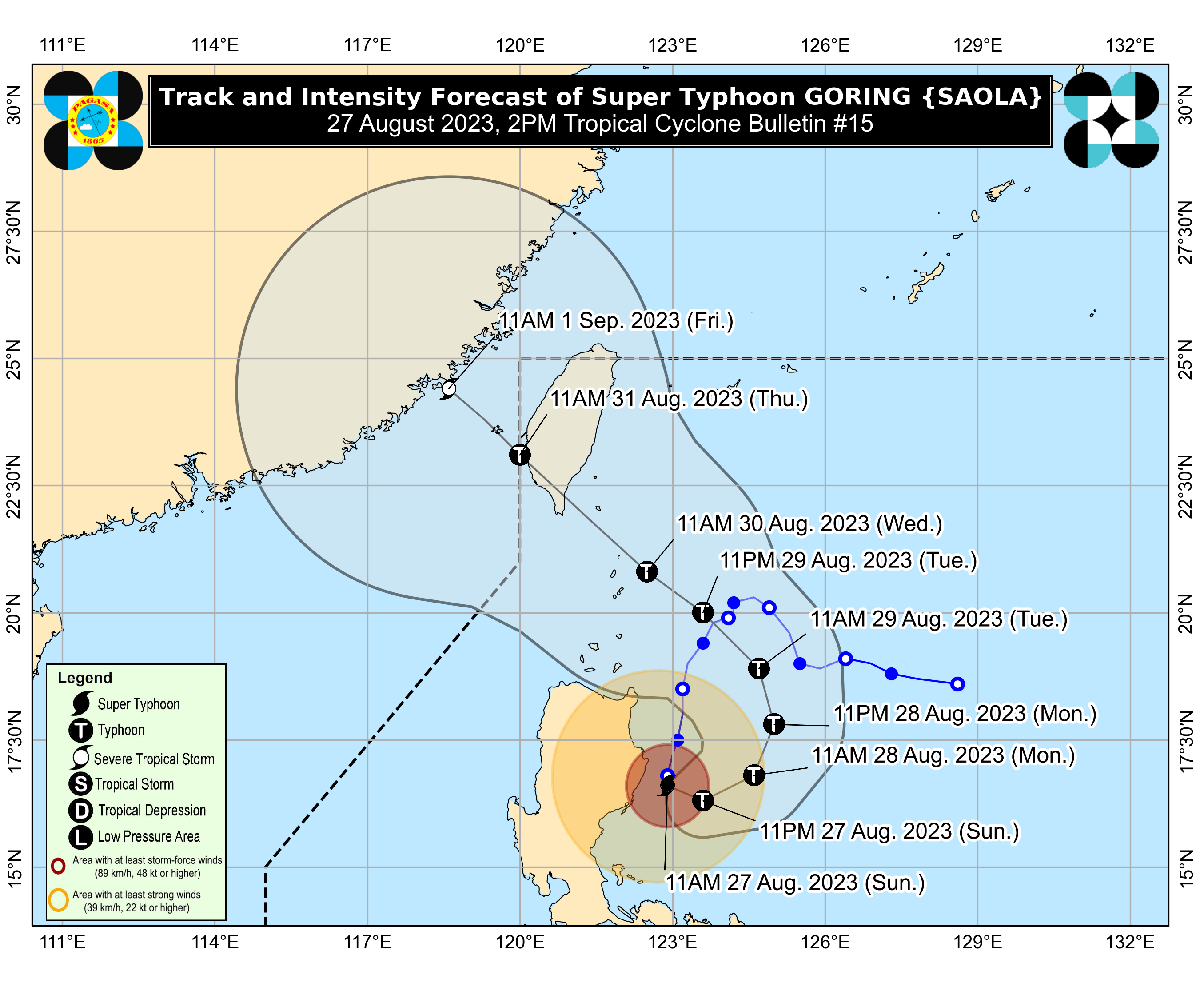
PAGASA said “Goring” is also expected to “remain at super typhoon category” until it makes landfall over southern Taiwan.
“It is likely that Goring will emerge over the Taiwan Strait and exit the PAR [Philippine Area of Responsibility] region on Friday as a severe tropical storm or a typhoon in its lowest limit,” PAGASA added.
Affected areas with TCWS Signal
PAGASA said the eastern portion of Isabela (Divilacan, Palanan, Dinapigue, Ilagan City, San Mariano) are still under Tropical Cyclone Wind Signal No. 3.
The areas under Signal No. 2 include the eastern portion of mainland Cagayan (Peñablanca, Baggao, Gattaran, Lal-Lo, Gonzaga, Santa Teresita, Buguey, Santa Ana, Enrile, Tuguegarao City), the northern and central portion of Isabela (Maconacon, Cabagan, Tumauini, San Pablo, Benito Soliven, San Guillermo, Jones, Echague, San Agustin, Angadanan, City of Cauayan, Naguilian, Gamu, Santa Maria, Santo Tomas, Delfin Albano, Quirino, Burgos, Reina Mercedes, Alicia, Luna, Quezon, Mallig, Roxas, San Manuel, Aurora, Cabatuan, San Mateo, San Isidro), the extreme northern portion of Aurora (Casiguran, Dinalungan, Dilasag), and the eastern portion of Quirino (Maddela).
Batanes, the rest of Cagayan including Babuyan Islands, the rest of Aurora, the rest of Quirino, the rest of Isabela, Apayao, Nueva Vizcaya, Ifugao, Mountain Province, Kalinga, Abra, the eastern portion of Ilocos Norte (Pagudpud, Adams, Vintar, Carasi, Nueva Era, Banna, Marcos, Dingras, Solsona, Piddig, Dumalneg, Bangui), Pollilo Islands, eastern portion of Benguet (Bokod, Buguias, Kabayan, Mankayan), eastern portion of Nueva Ecija (Carranglan, Pantabangan, Bongabon, Gabaldon, Laur, Rizal), and Calaguas Islands are under Signal No. 1.