


 Philippines
National
UP physicists utilize 300-year-old mathematical solution to bolster PH's disaster response
Philippines
National
UP physicists utilize 300-year-old mathematical solution to bolster PH's disaster response
UP physicists utilize 300-year-old mathematical solution to bolster PH's disaster response
By Sonny Daanoy


Physicists at the University of the Philippines Diliman (UPD) have introduced "network science" to help with faster and more efficient relief operations in the aftermath of typhoons in the country.
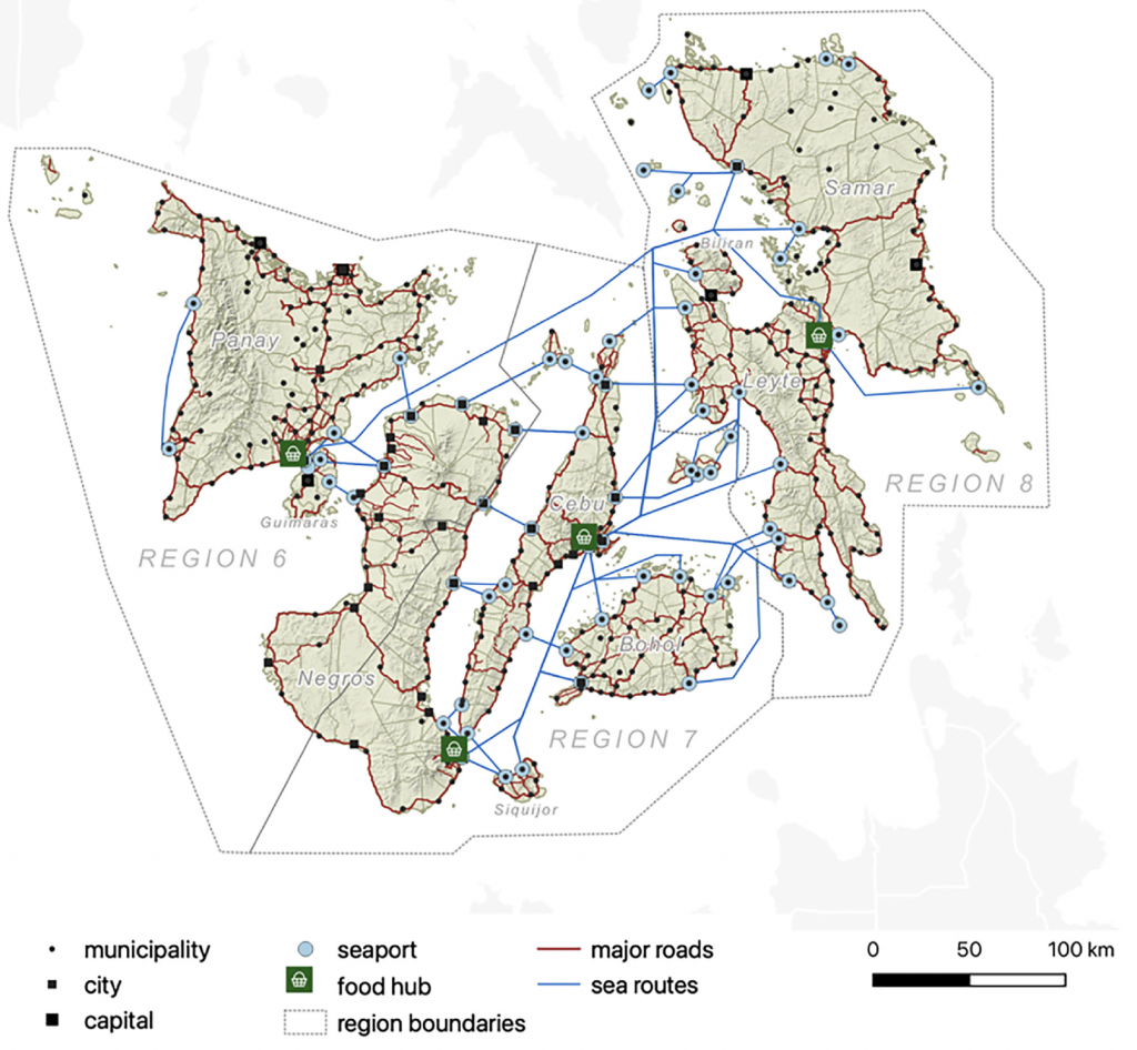
This solution was developed by May T. Lim and Reinabelle C. Reyes of the UPD-National Institute of Physics (UPD-NIP), along with independent researcher JC Albert C. Peralta, to conceptualize and model transportation networks for calculating the optimal ways to distribute relief goods.
It represented roads and sea routes as "edges" (lines connecting two points) and identified the intersections between roads and sea routes as "nodes" (points where lines intersect).
"Together, edges and nodes make up a graph, which can be applied to a variety of modeling applications, including disaster relief," UPD said in a statement.
"Network science was formally introduced by Swiss mathematician and physicist Leonhard Euler in the early 1700s.
It was also known as the "traveling salesman problem (TSP)," which was applied to determine the most efficient way to visit a set of destinations.
To model the progression of relief operations across various towns and districts, the researchers identified the key regional food hubs where relief packages are initially received.
"They then simulated the relief packages moving outwards from these hubs to the edges and nodes, like water flowing through a network of pipes," UPD said.
"As part of their model, they also assigned each edge with a travel time or the time it takes for a vehicle to traverse the road segment or sea route," it added.
Using this process, researchers can calculate how long it would take for relief to reach different destinations.
Actual application
The TSP was applied to determine the optimal route in the Visayas transport network system in the event of natural disasters. The researchers utilized geographic data from Google Maps, OpenStreetMap, and other publicly accessible databases.
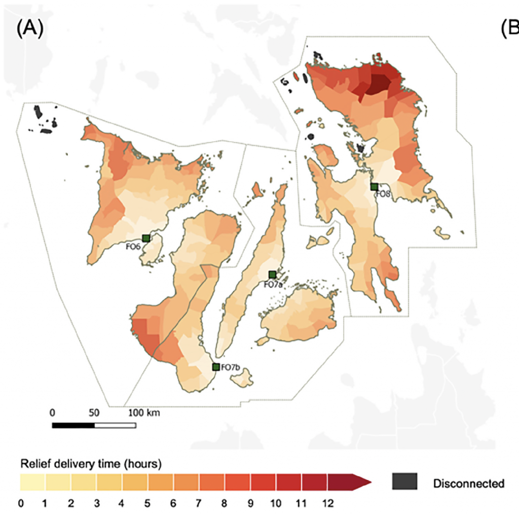
In this application, researchers concluded that Region 8, particularly Northern and Eastern Samar, is the most vulnerable to delays in relief delivery, with the journey taking as much as 12 hours for relief packages to reach these districts from the food hubs.
After drafting the nodes and edges, the physicists then eradicated nodes to mimic affected roads.
"Using the path of Typhoon Yolanda (Haiyan) as example, when even just one percent of the total nodes became inaccessible, 30 out of 251 towns became disconnected from the main network," UPD said.
"More worryingly, almost all towns in the region became inaccessible when only just five percent of all nodes were shut down," it added.
The experiment on the Visayas transport network exposed the extent of its vulnerability.
"We emphasize the need for a more decentralized and proactive form of relief logistics such as prepositioning relief goods, especially in or nearer to towns most vulnerable to disconnection," the researchers said.
Potential use across PH network systems
While the mathematical solution was explicitly tested on the Visayas transport network system, researchers emphasized its potential application to all network systems in the Philippines.
"Currently, only the Visayas network system is available, but more transport networks are expected to be available as more data is brought into the model," UPD said.
"They also said that the model's accuracy and usefulness could be improved by using data based on actual rather than hypothetical damage," it added.
Meanwhile, to showcase its utility, researchers developed a prototype app that provides a "user-friendly" interface for the public.
"It is our hope that policymakers will harness this potential for informed decision-making, strategic cost-benefit analysis for infrastructure investments, and effective data-driven transportation planning to enhance resilience in the face of future disasters," the researchers said.