


 Philippines
National
Typhoon Yolanda aftermath: Improvements in forecasting extreme weather events
Philippines
National
Typhoon Yolanda aftermath: Improvements in forecasting extreme weather events
Typhoon Yolanda aftermath: Improvements in forecasting extreme weather events


In 2013, one of the most powerful cyclones ever recorded hit the Philippines, leading to significant improvements in the country’s weather forecasting.
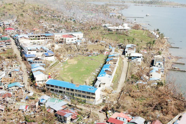
In commemoration of the 10th anniversary of Super Typhoon Yolanda’s occurrence, the Philippine Atmospheric Geophysical and Astronomical Services Administration (PAGASA) highlighted the “improvements” in forecasting and monitoring tropical cyclones and climate phenomena, as well as the actions that should be taken in preparation for future extreme weather events.
In an interview with the Manila Bulletin, PAGASA Assistant Weather Services Chief and spokesperson Chris Perez said being prepared for extreme weather events, such as typhoons, should be a “collective” effort.
“There should always be a collective effort, hindi lamang PAGASA ang dapat mag-adjust o magkaroon ng improvements kundi lahat tayo even ‘yung mga kababayan natin (There should always be a collective effort, not only PAGASA should adjust or should improve but all of us, even our countrymen),” Perez said.
He pointed out that PAGASA issues meteorological warnings, while partner agencies such as the National Disaster Risk Reduction and Management Council mobilize people at the local level before tropical cyclones strike.
Relying on ‘credible’ info
Perez said it is important that the public must rely on “legitimate” sources of information, such as PAGASA, for weather and climate updates.
“Lalo na ngayon na marami na tayong information na madaling makuha, but we have to be wary of the information kung authoritative ba ‘yung pinanggalingan o ito ba ay credible (Especially now that we can easily access information, but we still have to be wary of the information if it is authoritative or credible),” said Perez.
“Gamitin lang ‘yung information galing sa PAGASA at iwasan magpost ng mga bagay na not officially released by PAGASA kasi napakalaking bagay ang nagagawa ng social media para maiwasan ang confusion at comparison (Use only information from PAGASA and avoid posting matters, which are not officially released by PAGASA—as the social media brings so much effect to the lives of people—to avoid confusion and comparison),” he added.
Perez said people should only rely on PAGASA’s information and advisories and obey the authority to avoid “regretting” their decisions.
PAGASA also said one factor to be considered when issuing warnings is providing historical background to the country’s previous experiences with natural disasters.
Although PAGASA has provided advisories and details on storm surges, floods, and landslides, among other threats, Perez pointed out that “there is a need for a more developed information and education campaign.”
Improving weather forecasts
Perez said there is currently a program called “Project Maghanda,” which was launched in 2022, and “Project Handa,” which was unveiled in 2023, to educate the public about the dangers of natural disasters like typhoons.
“Through these programs, we provide hydrometeorological hazards information, as well as the associated effects and adjustments that can be made, just to name a few,” he added.
Perez also explained that after Yolanda, PAGASA now releases a three-hourly forecast when the tropical cyclone is about to make landfall, as opposed to the six-hourly forecast when the tropical cyclone is still far from the country.
The continuous upgrade of equipment and acquisition of new technology is also maintained, he said.
“We have radars before Yolanda pero mas dinagdagan natin ngayon (We have radars before Yolanda but we increased its number now),” Perez said.
Before Yolanda, there was also hazard mapping, which is scheduled to be updated, and PAGASA has been coordinating with partner agencies in terms of disaster preparedness and mitigation, he pointed out.
Storm Signal No. 5, ‘super typhoon’ officially used
In 2015, PAGASA officially added Tropical Cyclone Wind Signal No. 5 to its original four-tier public storm signal warnings due to the increased severity of typhoons that have been hitting the country in the past decade.
PAGASA’s Public Storm Warning Signal or PSWS System was changed to Tropical Cyclone Wind Signal or TCSW System.
The revision was made along with the introduction of the super typhoon category.
“Under the new Tropical Cyclone Wind Signal System, TCWS No. 5 was introduced to warn the public with strong winds of more than 220 kilometers per hour (i.e., for tropical cyclones classified as super typhoon) roughly 12 hours before the onset of such conditions,” PAGASA said.
It modified its tropical cyclone wind signal system once again in 2022.
“After almost seven years of implementation, PAGASA decided to modify several changes to the TCWS pending the completion of the sunset review of its warning system for Tropical Cyclone (TC) winds,” PAGASA said.
The changes are based on the adoption of best practices from other tropical cyclone warning centers and regionally accepted operational standards, developments in objective guidance for tropical cyclone wind swaths, operational experiences and challenges encountered by typhoon forecasters, and feedback from end-users and stakeholders.
As of 2022, the updated warning system is as follows:
* Tropical Depression — with maximum winds of 39-62 kilometers per hour (kph)
Highest tropical cyclone wind signal that will be raised — Signal No. 1
* Tropical Storm — with maximum winds of 62-88 kph
Highest tropical cyclone wind signal — Signal No. 2
* Severe tropical storm — with maximum winds of 89-117 kph
Highest tropical cyclone wind signal — Signal No. 3
* Typhoon — with maximum winds of 118-184 kph
Highest tropical cyclone wind signal — Signal No. 4
* Super Typhoon — with maximum winds of 185 kph or higher
Highest tropical cyclone wind signal — Signal No. 5
Storm surge warning system
The term “storm surge,” which PAGASA defined as the “abnormal increase in sea water level associated with the passage of a tropical storm or typhoon,” was also highlighted.
During the observance of the post-effects of Yolanda PAGASA said that further efforts could have been put into elaborating to the citizens and government the extent of a storm surge.
In 2019, PAGASA upgraded its storm surge warning systems by launching a much more detailed guide.
PAGASA included the storm surge height forecast and related effects in the color-guided design where the public can base their actions during a storm surge.
Storm surges of between 0.5 and 1 meter height are considered possible under a yellow warning; storm surges of between 1.1 and 3 meters height are considered possible under an orange warning.
Meanwhile, a three-meter-tall storm surge is possible under a red warning. It denotes a “catastrophic” situation requiring evacuation.
Moreover, PAGASA modified the warning scheme into two classifications—storm surge watch, which monitors moderate to high-risk storm sur