


Tropical cyclone 'Jenny' tracker


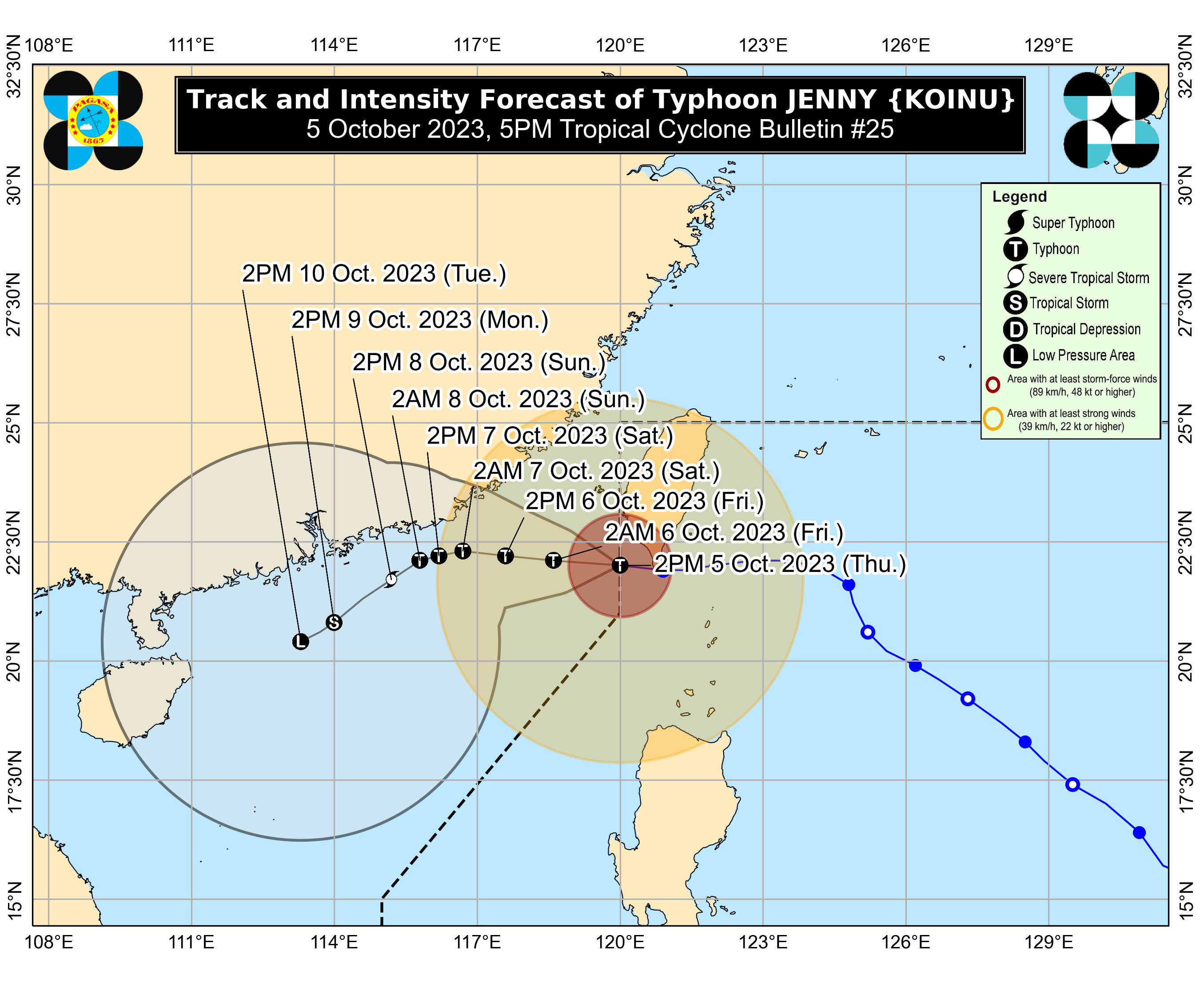
5 p.m., Oct. 5
Typhoon Jenny (international name: Koinu) further weakened and now outside the Philippine area of responsibility (PAR), said PAGASA.
Typhoon Jenny has maximum sustained winds of 140 kilometers per hour (kph) near the center and gusts of up to 170 kph, moving westward at 15 kph.
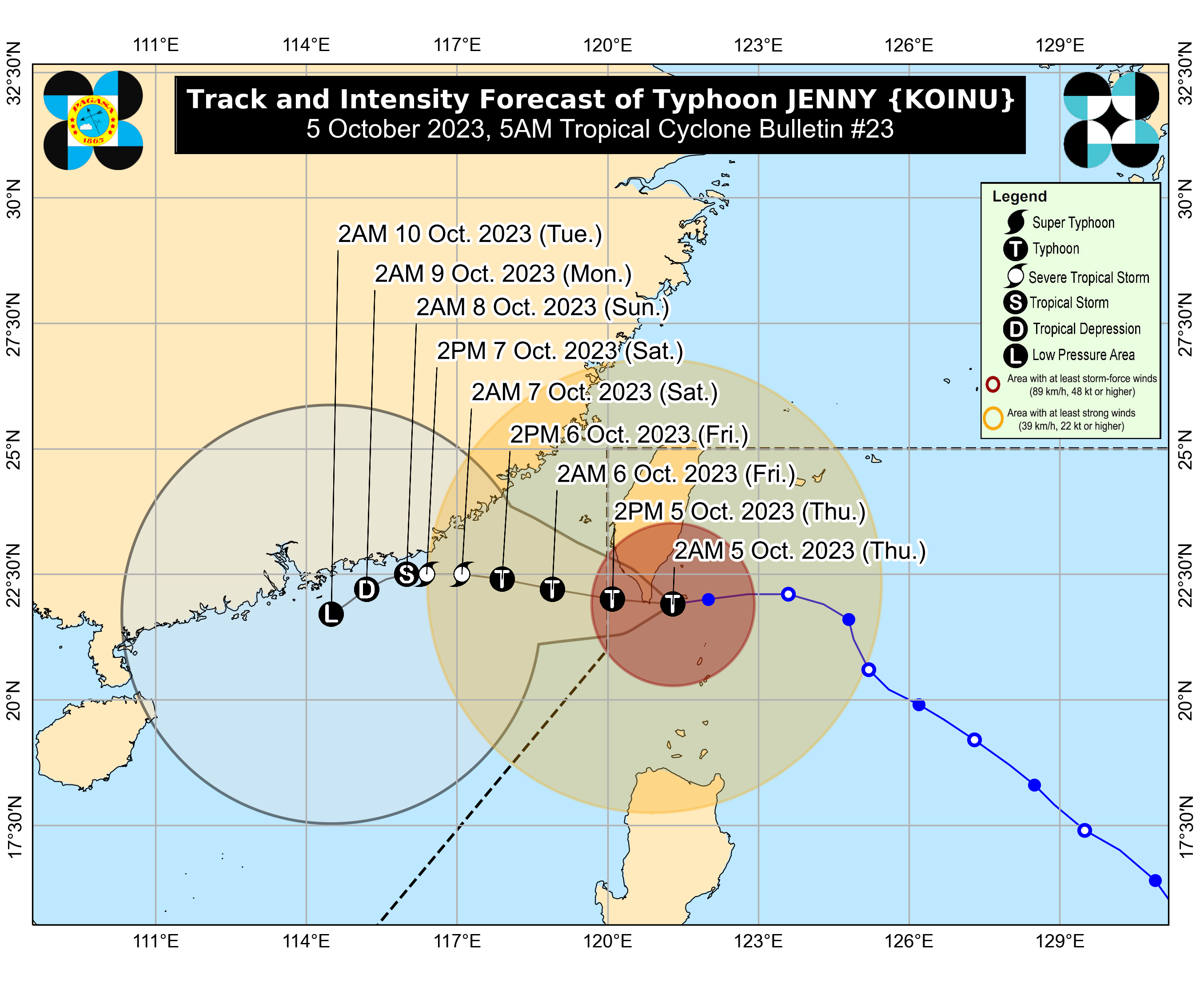
5 a.m., Oct. 5
PAGASA located the center of the eye of typhoon Jenny 140 kilometers north-northwest of Itbayat, Batanes.
It was moving westward at 10 kilometers per hour (kph)
It may exit the country’s area of responsibility on Thursday afternoon or evening, PAGASA said.
11 p.m., Oct. 4
The Philippine Atmospheric, Geophysical and Astronomical Services Administration (PAGASA) on Wednesday, Oct. 4, said typhoon Jenny (international name: Koinu) intensified while passing north of Batanes Province toward Southern Taiwan.
"Jenny' was seen 125 kilometers (km) north of Itbayat, Batanes, while moving 15 kilometers per hour (kph).
It has maximum sustained winds of 165 kph and gustiness of up to 205 kph.

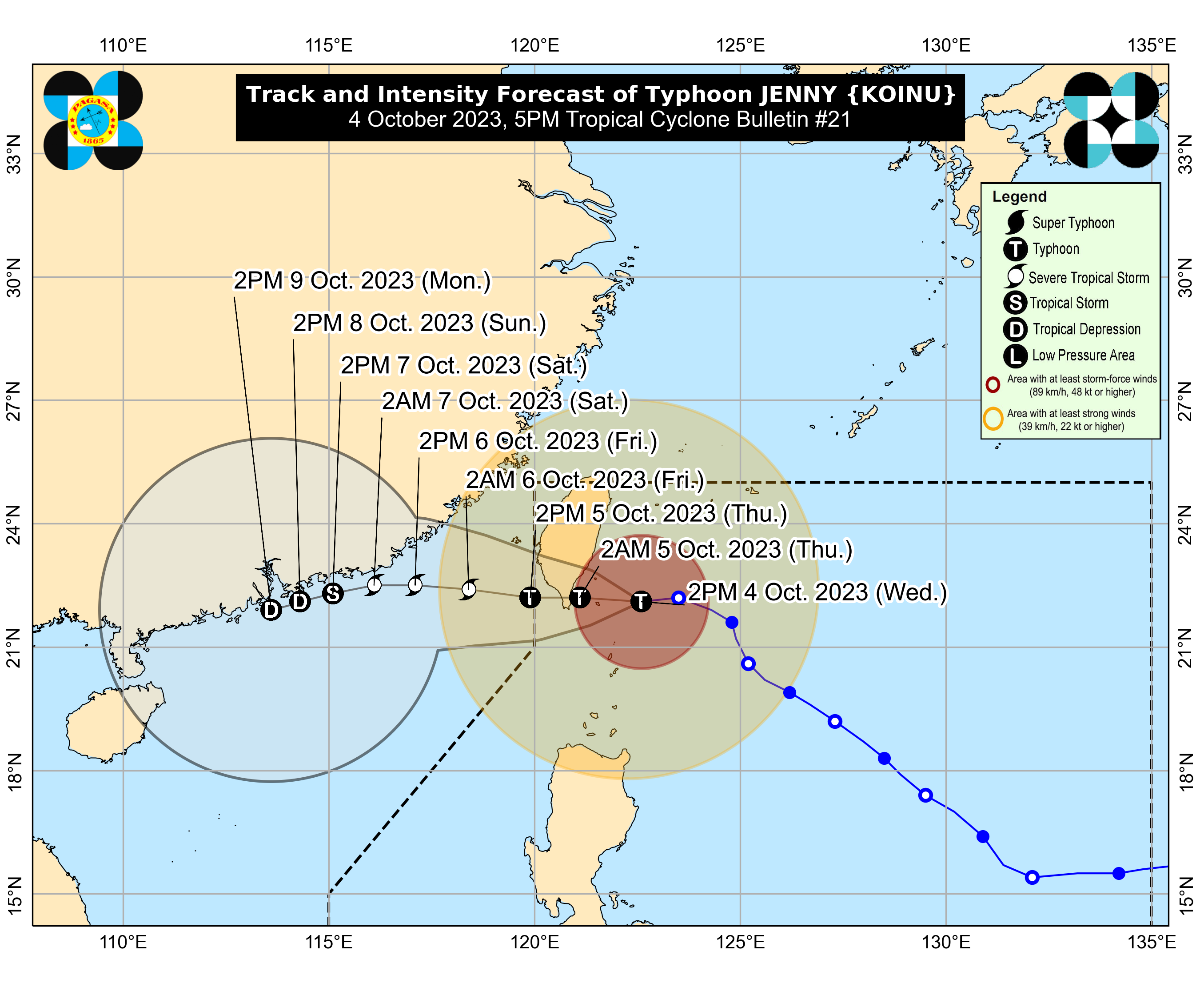
5 p.m., Oct. 4
The state weather bureau on Wednesday, Oct. 4, reported the slight intensification of typhoon Jenny (international name: Koinu) as it moved westward toward southern Taiwan.
"Jenny' was seen in north, northeast of Itbayat, Batanes, while moving 15 kilometers per hour (kph).
It has maximum sustained winds of 155 kph and gustiness of up to 190 kph.
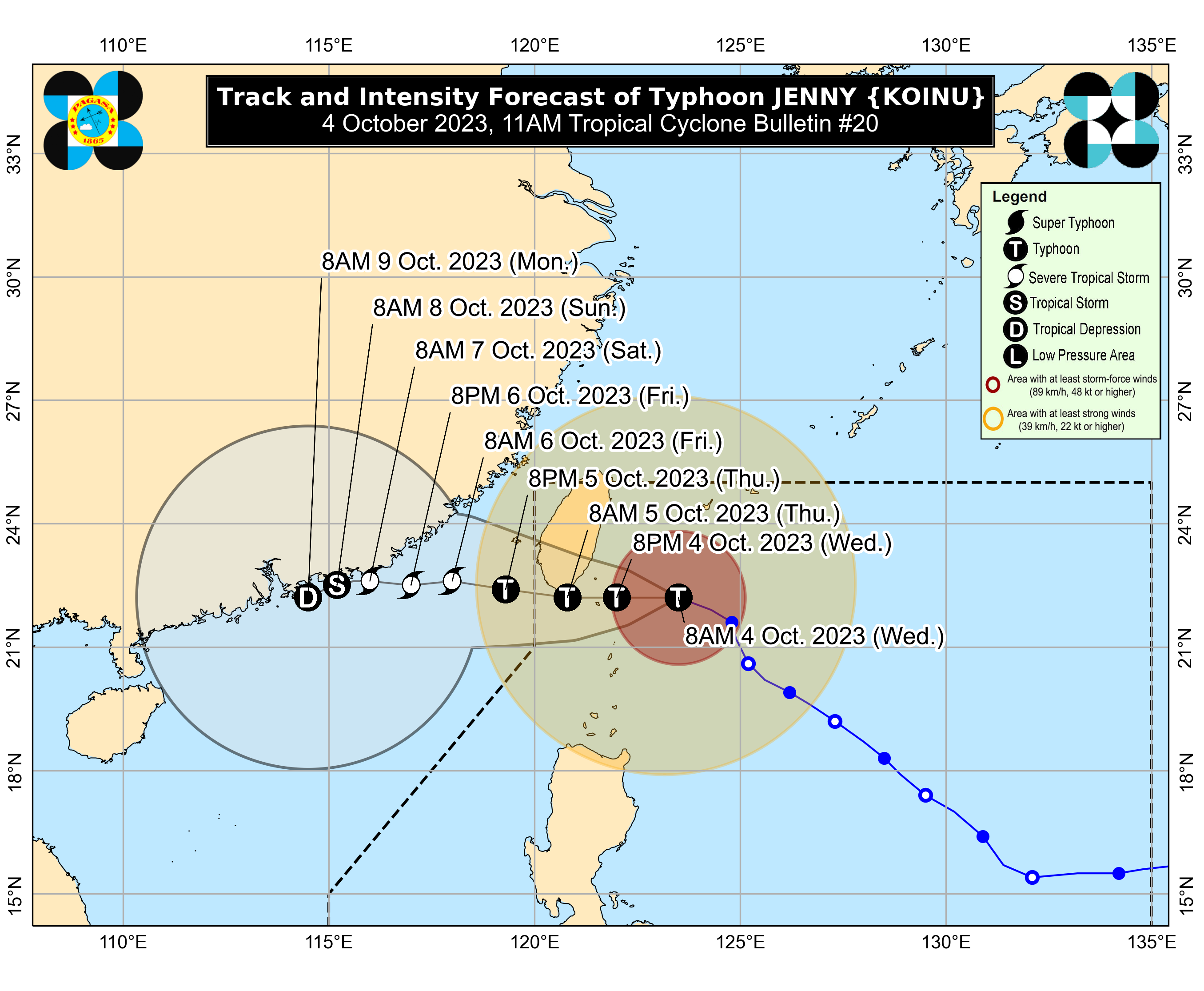
11 a.m., Oct. 4
Typhoon Jenny (international name: Koinu) maintained its strength as it accelerated at 15 kilometers per hour (kph) west-northwest toward Taiwan, PAGASA said.
The center of the eye of the typhoon was located 210 kilometers northeast of Itbayat, Batanes.
It has maximum sustained winds of 150 kph near the center and gusts of up to 185 kph.

5 a.m. Oct.4
Typhoon Jenny slightly weakened as it started to turn west-northwest at 10 kilometers per hour (kph) toward southern Taiwan, PAGASA said.
The center of the eye of the typhoon was located 270 kilometers east-northeast of Itbayat, Batanes.
It has maximum sustained winds of 150 kph near the center and gusts of up to 185 kph.
Jenny may move west-northwestward in the next 12 hours, then westward before making landfall over the southern portion of Taiwan on Thursday morning, Oct. 5, and exit the Philippine area of responsibility (PAR) in the afternoon or evening.
11 p.m., Oct. 3
Itbayat, Batanes is under Tropical Cyclone Wind Signal (TCWS) No. 3, while typhoon Jenny maintains its strength, said PAGASA on Tuesday, Oct. 3.
"Jenny" is moving north-northwestward at 10 kilometers per hour (kph) while its center was seen at 305 kilometers east-northeast of Itbayat, Batanes.
Typhoon Jenny has maximum sustained winds of 155 kph near the center and gustiness of up to 190 kph.
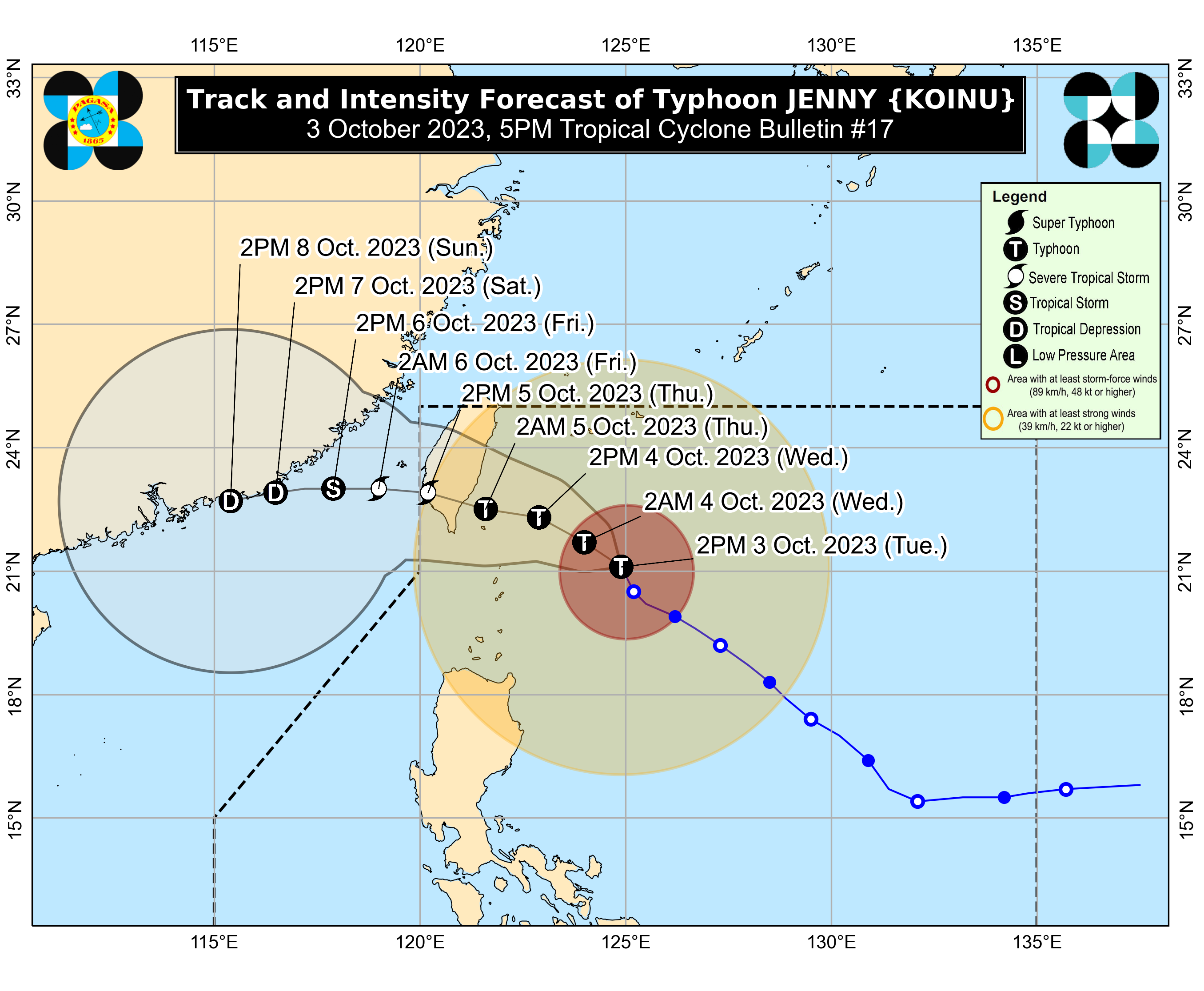
5 p.m., Oct. 3
Typhoon Jenny maintained its strength as it moved north-northwestward at 10 kilometers per hour (kph) over the Philippine Sea, said PAGASA on Tuesday, Oct. 3.
The center of Typhoon Jenny was observed at 325 kilometers east-northeast of Itbayat, Batanes and has maximum sustained winds of 155 kph near the center and gustiness of up to 190 kph.
Based on track forecast of PAGASA, "Jenny" will make landfall over the southern portion of Taiwan between Wednesday late evening or Thursday morning then exit the Philippine Area of Responsibility (PAR) between Thursday morning and afternoon. 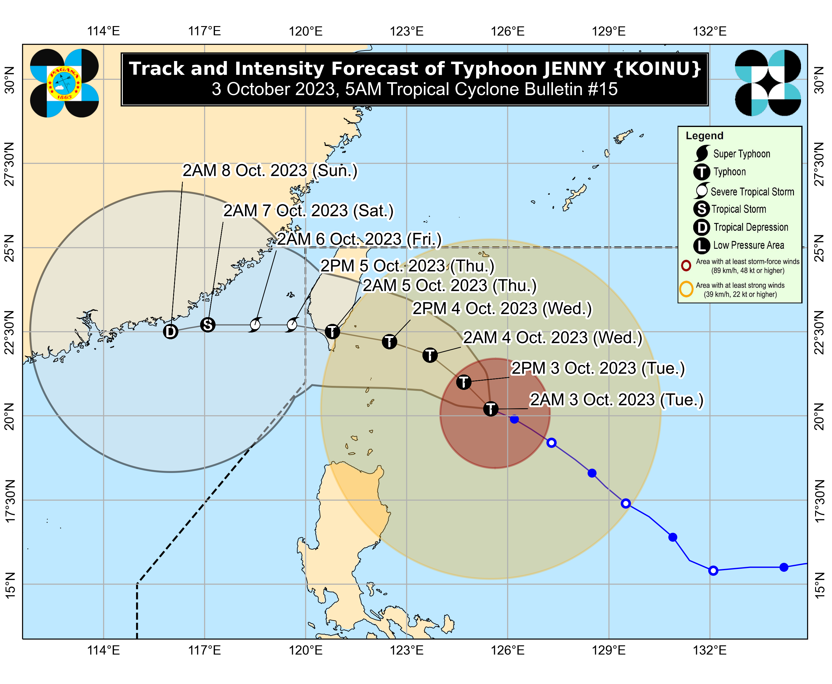
5 a.m., Oct. 3
PAGASA said the center of the eye of typhoon Jenny was located 350 kilometers east of Basco, Batanes.
Jenny is moving west-northwestward at 15 kph.
It is no longer expected to make landfall in the country, but it is still close enough to bring strong winds and rains to some parts of Northern Luzon.
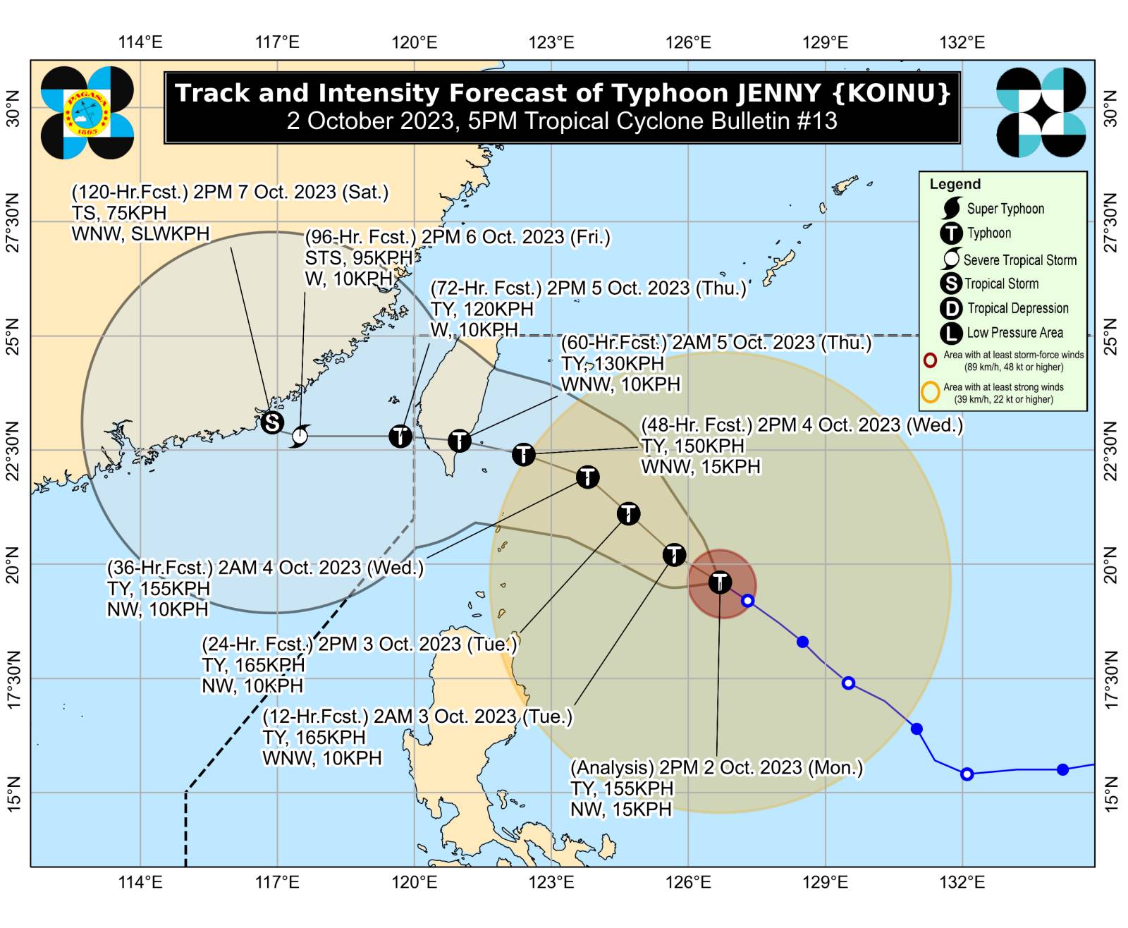
11 p.m., Oct. 2
The state weather bureau on Monday, Oct. 2, raised Tropical Cyclone Wind Signal (TCWS) No. 2 over Batanes as Typhoon Jenny continued to intensify while moving northwestward.
Typhoon Jenny was last spotted 410 km East of Basco, Batanes, moving 10 kilometers per hour (kph).
It has a maximum sustained winds of 165 kph and gustiness of up to 205 kph.
5 p.m. Oct. 2
The Philippine Atmospheric, Geophysical Astronomical and Services Administration (PAGASA) on Monday, Oct. 2 said Tropical Cyclone Wind Signal (TCWS) number 1 was raised over parts of Northern Luzon.
"Jenny" steadily intensified at maximum sustained winds of 155 kph near the center with gustiness of up to 190kph, moving northwestward at 15kph, said PAGASA.
The center of the eye of Typhoon Jenny was last observed at 485 kilometers East of Basco, Batanes.
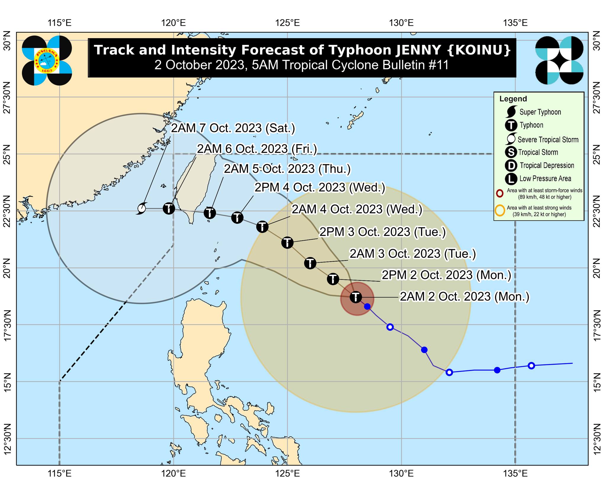
5 a.m., Oct. 2
Typhoon Jenny was last spotted 655 kilometers east of Aparri, Cagayan, and is moving northwestward at 10 kph.
“On the track forecast, Jenny will make landfall over the southern portion of Taiwan on Thursday afternoon or evening (Oct. 5), then exit the Philippine area of responsibility (PAR) over the Taiwan Strait between Thursday evening or Friday morning (Oct. 6),” PAGASA said.
“A landfall or close approach scenario over the Batanes area is still not ruled out, although the likelihood is decreasing,” it pointed out.
11p.m., Oct. 1
Severe Tropical Storm (STS) Jenny intensified further and is nearing typhoon category, said the Philippine Atmospheric, Geophysical and Astronomical Services Administration (PAGASA) on Sunday evening, Oct. 1.
“Jenny” was last spotted 715 km east of Aparri, Cagayan, moving northwestward at 10 kilometers per hour (kph).
It has maximum sustained winds of 110 kph near the center and gustiness of up to 135 kph.
5 p.m., Oct. 1
The Philippine Atmospheric, Geophysical and Astronomical Services Administration (PAGASA), at the 5 p.m. weather update on Sunday, Oct. 1 raised tropical storm wind signal (TCWS) number 1 over Batanes.
Severe Tropical Storm (STS) Jenny was last spotted 760 kilometers (km) east of Aparri, Cagayan, moving 15 kilometers per hour (kph).
It has a maximum sustained winds of 100 kph and gustiness of up to 125 kph.
11 a.m., Oct. 1
PAGASA last spotted severe tropical storm Jenny 790 kilometers east of Tuguegarao City, Cagayan, and is moving west-northwestward at 15 kph.
It said Jenny may continue to move northwestward until Monday, before turning west-northwestward on Tuesday towards the Luzon Strait, and westward on Thursday, (Oct. 5).
“On the track forecast, Jenny will pass over the Bashi Channel between Batanes and the southern portion of Taiwan between Wednesday evening and Thursday morning,” it said.
“However, a landfall or close approach scenario over extreme Northern Luzon is still not ruled out since these scenarios are within the forecast confidence cone,” it pointed out.
5 a.m., Oct. 1
Tropical storm Jenny was last located 835 kilometers east of Central Luzon, moving northwestward at 20 kph.
PAGASA said it may continue to move northwestward until Monday, Oct. 2, then turn west-northwestward on Tuesday, Oct. 3 toward the Luzon Strait.
It may move westward on Wednesday, Oct. 4, then pass over the Bashi Channel between Batanes and the southern portion of Taiwan between Wednesday evening and Thursday morning, Oct. 4 and 5.
“However, a landfall or close approach scenario over extreme Northern Luzon is still not ruled out since these scenarios are within the forecast confidence cone,” PAGASA said.
11 p.m., Sept. 30
The Philippine Atmospheric, Geophysical and Astronomical Services Administration (PAGASA) reported the slight intensification of Tropical Storm (TS) Jenny as it moved northwestward over the Philippine Sea on Saturday evening, Sept. 30.
PAGASA spotted the tropical storm 915 km East of Central Luzon, moving northwestward at 15 kilometers per hour (kph).
It has a maximum sustained winds of 75 kph near the center and gustiness of up to 90 kph.
5 p.m., Sept. 30
PAGASA said “Jenny” decelerates as it moves northwestward over the Philippine Sea.
At this time, Tropical Storm Jenny is “not directly affecting the country” but heavy rainfall may be experienced over Batanes and Babuyan Islands due to its proximity.
As of 4 p.m., tropical storm Jenny’s center was located 995 km east of Central Luzon.
PAGASA said that “Jenny” would steadily intensify throughout the forecast period and might become a “severe tropical storm” on Sunday, Oct. 1.
11:00 a.m., Sept. 30
PAGASA said that "Jenny" is accelerating west-southwestward over the Philippine Sea while maintaining its strength.
Its center was located at 11 a.m. at 1,025 kilometers East of Central Luzon, while still having maximum sustained winds of 65 km/h near the center, gustiness of up to 80 km/h, and a central pressure of 1000 hPa according to the report.
Strong to gale-force winds extend outwards up to 330 km from the storm's center, said PAGASA.
PAGASA said "Jenny" is moving west-southwestward at 35 kilometers per hour.
No wind signal hoisted at this time, said PAGASA.
5 a.m., Sept 30
"Jenny" is expected to move west-northwestward, on Sept. 30, while northwestward or north-northwestward on Sunday to Monday.
PAGASA said that "Jenny" may be under the Severe Tropical Storm category on Sunday, Oct. 1.
"A west northwestward turn towards Luzon Strait-Southern Taiwan area may take place on Tuesday," said PAGASA.
"A landfall or close approach scenario over Extreme Northern Luzon or northeastern mainland Cagayan is not ruled out since these scenarios are within the forecast confidence cone," it added.
PAGASA also said that "Jenny" may reach typhoon category on late Monday or on Tuesday.
11 p.m., Sept. 29
Tropical depression Jenny was last spotted 1,240 kilometers east of Central Luzon, moving westward at 15 kph, PAGASA said.
It may move west-northwestward on Saturday, Sept. 30, then northwestward or north-northwestward on Sunday, Oct. 1, and Monday, Oct. 2.
“A landfall or close approach scenario over extreme Northern Luzon or northeastern mainland Cagayan is not ruled out since these scenarios are within the forecast confidence cone,” PAGASA said.
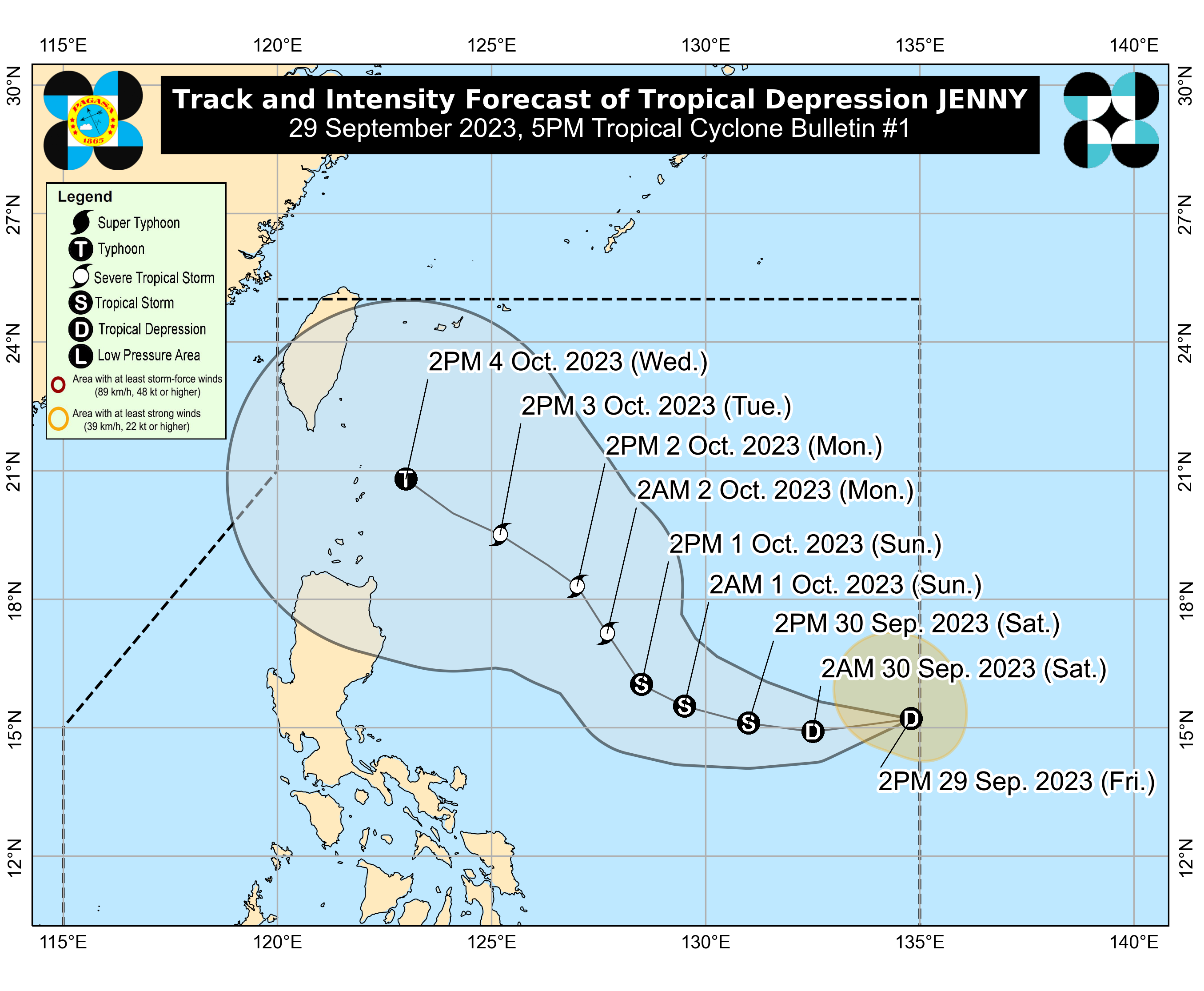
5 p.m., Sept. 29
PAGASA said Jenny was located 1,400 kilometers east of southeastern Luzon, moving westward at 20 kilometers per hour (kph).
“Jenny is forecast to track generally westward or west-northwestward until Saturday (Sept. 30) before turning further north over the Philippine Sea east of Northern and Central Luzon,” PAGASA said.
“On the forecast track, [Jenny will have] a close approach over the Batanes area by Wednesday (Oct. 4). A landfall scenario over Batanes-Babuyan or northeastern mainland Cagayan is not ruled out since this is within the forecast confidence cone,” it pointed out.
2 p.m., Sept. 29
The low pressure area east of Central Luzon developed into a tropical depression, and was named “Jenny.”
Jenny is the 10th tropical cyclone for 2023 and second for September.