ADVERTISEMENT

'Jenny' intensifies into severe tropical storm; heavy rains likely over parts of PH

Published Oct 1, 2023 04:43 am
IMG_3339.jpeg
Satellite image of Severe Tropical Storm Jenny (international name: Koinu) (PAGASA)

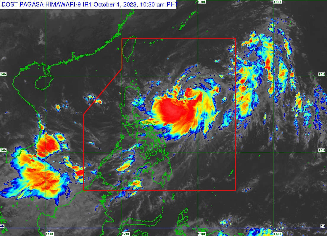
Tropical cyclone “Jenny” (international name: Koinu) continued to strengthen and is now a severe tropical storm, said the Philippine Atmospheric, Geophysical and Astronomical Services Administration (PAGASA) on Sunday, Oct. 1.

In its 11 a.m. bulletin, PAGASA said Jenny had maximum sustained winds of 95 kilometers per hour (kph) near the center and gusts of up to 115 kph.

It was last spotted 790 kilometers east of Tuguegarao City, Cagayan, and is moving west-northwestward at 15 kph.

Heavy rains

Brace for heavy rains as Jenny may bring moderate to heavy rains over mainland Cagayan, Isabela, Quezon including Polillo Islands, Camarines Norte, Camarines Sur, Catanduanes, Albay, Sorsogon, Northern Samar, and Eastern Samar in the next few hours.

On Tuesday, Oct. 2, heavy rains may also prevail over Batanes, Babuyan Islands, mainland Cagayan, and Isabela, and on Wednesday, Oct. 3 in Batanes, Babuyan Islands, mainland Cagayan, Isabela, Ilocos Norte, and Apayao.

PAGASA said Jenny may also enhance the effect of the southwest monsoon, or “habagat,” and bring occasional to monsoon rains over the western portions of Central and Southern Luzon, Visayas, and Mindanao in the next three days.

Wind warnings

PAGASA said current forecast scenario shows that tropical cyclone wind signals may be hoisted over extreme Northern Luzon on Sunday afternoon or evening in anticipation of the onset of Jenny’s severe winds. 

Meanwhile, the enhancement of the southwest monsoon will bring gusty conditions to some areas that are currently not under wind warnings over the next three days.

Gusty conditions may be experienced in Oriental Mindoro, Occidental Mindoro, Marinduque, Romblon, Palawan, and Western Visayas on Monday; and Western Visayas, Oriental Mindoro, Occidental Mindoro, Marinduque, Romblon, Palawan, Cavite, Laguna, Batangas, Rizal, Quezon, and Bicol Region on Tuesday.

Landfall still possible

PAGASA projected Jenny to continue to move northwestward until Monday, before turning west-northwestward on Tuesday towards the Luzon Strait, and westward on Thursday, (Oct. 5).

“On the track forecast, Jenny will pass over the Bashi Channel between Batanes and the southern portion of Taiwan between Wednesday evening and Thursday morning,” it said.

“However, a landfall or close approach scenario over extreme Northern Luzon is still not ruled out since these scenarios are within the forecast confidence cone,” it pointed out.

PAGASA also said Jenny may intensify steadily throughout the forecast period.

It may reach typhoon status on Monday and reach a peak intensity of 150 kph by Tuesday.

Related Tags

Jenny JennyPH PAGASA
ADVERTISEMENT
.most-popular .layout-ratio{ padding-bottom: 79.13%; } @media (min-width: 768px) and (max-width: 1024px) { .widget-title { font-size: 15px !important; } }

{{ articles_filter_1561_widget.title }}

.most-popular .layout-ratio{ padding-bottom: 79.13%; } @media (min-width: 768px) and (max-width: 1024px) { .widget-title { font-size: 15px !important; } }

{{ articles_filter_1562_widget.title }}

.most-popular .layout-ratio{ padding-bottom: 79.13%; } @media (min-width: 768px) and (max-width: 1024px) { .widget-title { font-size: 15px !important; } }

{{ articles_filter_1563_widget.title }}

{{ articles_filter_1564_widget.title }}

.mb-article-details { position: relative; } .mb-article-details .article-body-preview, .mb-article-details .article-body-summary{ font-size: 17px; line-height: 30px; font-family: "Libre Caslon Text", serif; color: #000; } .mb-article-details .article-body-preview iframe , .mb-article-details .article-body-summary iframe{ width: 100%; margin: auto; } .read-more-background { background: linear-gradient(180deg, color(display-p3 1.000 1.000 1.000 / 0) 13.75%, color(display-p3 1.000 1.000 1.000 / 0.8) 30.79%, color(display-p3 1.000 1.000 1.000) 72.5%); position: absolute; height: 200px; width: 100%; bottom: 0; display: flex; justify-content: center; align-items: center; padding: 0; } .read-more-background a{ color: #000; } .read-more-btn { padding: 17px 45px; font-family: Inter; font-weight: 700; font-size: 18px; line-height: 16px; text-align: center; vertical-align: middle; border: 1px solid black; background-color: white; } .hidden { display: none; }
function initializeAllSwipers() { // Get all hidden inputs with cms_article_id document.querySelectorAll('[id^="cms_article_id_"]').forEach(function (input) { const cmsArticleId = input.value; const articleSelector = '#article-' + cmsArticleId + ' .body_images'; const swiperElement = document.querySelector(articleSelector); if (swiperElement && !swiperElement.classList.contains('swiper-initialized')) { new Swiper(articleSelector, { loop: true, pagination: false, navigation: { nextEl: '#article-' + cmsArticleId + ' .swiper-button-next', prevEl: '#article-' + cmsArticleId + ' .swiper-button-prev', }, }); } }); } setTimeout(initializeAllSwipers, 3000); const intersectionObserver = new IntersectionObserver( (entries) => { entries.forEach((entry) => { if (entry.isIntersecting) { const newUrl = entry.target.getAttribute("data-url"); if (newUrl) { history.pushState(null, null, newUrl); let article = entry.target; // Extract metadata const author = article.querySelector('.author-section').textContent.replace('By', '').trim(); const section = article.querySelector('.section-info ').textContent.replace(' ', ' '); const title = article.querySelector('.article-title h1').textContent; // Parse URL for Chartbeat path format const parsedUrl = new URL(newUrl, window.location.origin); const cleanUrl = parsedUrl.host + parsedUrl.pathname; // Update Chartbeat configuration if (typeof window._sf_async_config !== 'undefined') { window._sf_async_config.path = cleanUrl; window._sf_async_config.sections = section; window._sf_async_config.authors = author; } // Track virtual page view with Chartbeat if (typeof pSUPERFLY !== 'undefined' && typeof pSUPERFLY.virtualPage === 'function') { try { pSUPERFLY.virtualPage({ path: cleanUrl, title: title, sections: section, authors: author }); } catch (error) { console.error('ping error', error); } } // Optional: Update document title if (title && title !== document.title) { document.title = title; } } } }); }, { threshold: 0.1 } ); function showArticleBody(button) { const article = button.closest("article"); const summary = article.querySelector(".article-body-summary"); const body = article.querySelector(".article-body-preview"); const readMoreSection = article.querySelector(".read-more-background"); // Hide summary and read-more section summary.style.display = "none"; readMoreSection.style.display = "none"; // Show the full article body body.classList.remove("hidden"); } document.addEventListener("DOMContentLoaded", () => { let loadCount = 0; // Track how many times articles are loaded const offset = [1, 2, 3, 4, 5, 6, 7, 8, 9, 10]; // Offset values const currentUrl = window.location.pathname.substring(1); let isLoading = false; // Prevent multiple calls if (!currentUrl) { console.log("Current URL is invalid."); return; } const sentinel = document.getElementById("load-more-sentinel"); if (!sentinel) { console.log("Sentinel element not found."); return; } function isSentinelVisible() { const rect = sentinel.getBoundingClientRect(); return ( rect.top < window.innerHeight && rect.bottom >= 0 ); } function onScroll() { if (isLoading) return; if (isSentinelVisible()) { if (loadCount >= offset.length) { console.log("Maximum load attempts reached."); window.removeEventListener("scroll", onScroll); return; } isLoading = true; const currentOffset = offset[loadCount]; window.loadMoreItems().then(() => { let article = document.querySelector('#widget_1690 > div:nth-last-of-type(2) article'); intersectionObserver.observe(article) loadCount++; }).catch(error => { console.error("Error loading more items:", error); }).finally(() => { isLoading = false; }); } } window.addEventListener("scroll", onScroll); });

Sign up by email to receive news.