


 Philippines
National
Philippines' first tropical cyclone of 2024 may develop on May 24
Philippines
National
Philippines' first tropical cyclone of 2024 may develop on May 24
Philippines' first tropical cyclone of 2024 may develop on May 24


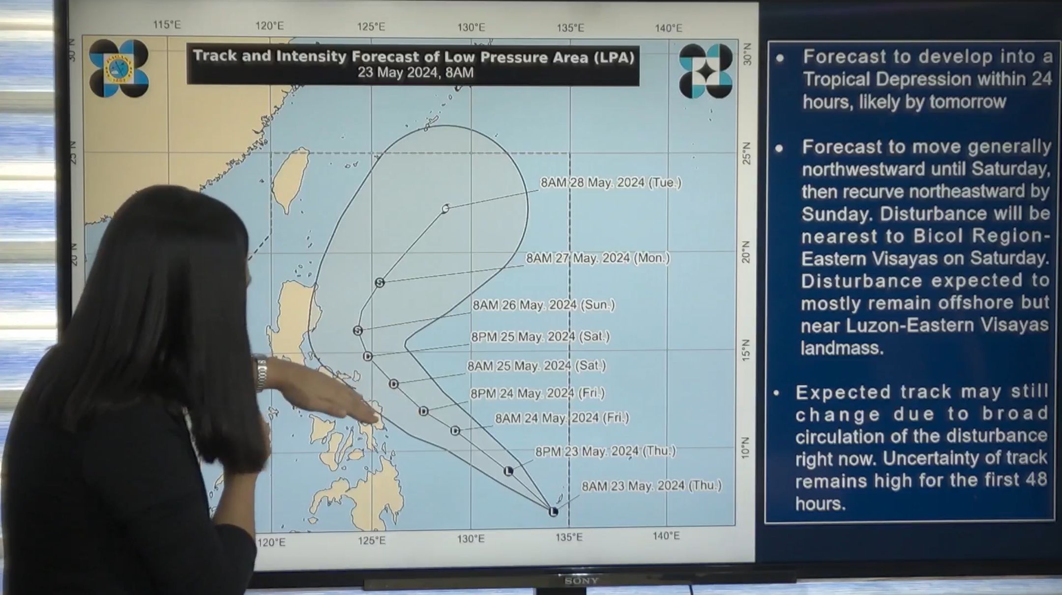
The Philippine Atmospheric, Geophysical and Astronomical Services Administration (PAGASA) said the low pressure area (LPA) east of Mindanao has a high likelihood of developing into the country’s first tropical cyclone of 2024.
During a press briefing on Thursday, May 23, PAGASA Weather Specialist Ana Clauren-Jorda said the LPA may develop into a tropical depression by Friday, May 24, at which point PAGASA will assign it the local name “Aghon.”
The LPA entered the Philippine area of responsibility (PAR) at 5 a.m. on Thursday, and was located 870 kilometers east of southeastern Mindanao around 10 a.m.
Clauren-Jorda said the weather disturbance may move northwestward until Saturday, May 25, then “recurve” northeastward by Sunday, May 26.
While a landfall scenario is not anticipated, the disturbance is projected to move near the Bicol Region-Eastern Visayas area by Saturday.
Although the disturbance is expected to mostly remain offshore but close to the Luzon-Eastern Visayas landmass, Clauren-Jorda said the current track may still change due to its broad circulation.
She added that uncertainty regarding its track remains high over the next 48 hours.
She also pointed out the possibility of hoisting tropical cyclone wind signals over portions of the Bicol Region and Eastern Visayas by the initial issuance of a tropical cyclone bulletin on Friday.
Rainfall forecast
Clauren-Jorda said the trough or extension of the LPA may begin to affect the northeastern part of Mindanao, bringing “light to moderate with at times heavy rains” over Surigao del Norte, Surigao del Sur, and Dinagat Islands.
By Friday, she said rains from the potential cyclone will be moderate to heavy over Eastern Samar and Northern Samar, while light to moderate rains may prevail over the Bicol Region, the rest of Caraga, and the rest of Eastern Visayas.
She pointed out that by Saturday, moderate to heavy to, at times, intense rains are possible over Catanduanes, Camarines Sur, and Northern Samar, while light to moderate rains are likely over Quezon, including Polillo Islands, the rest of Bicol Region, and the rest of Eastern Visayas.
Residents in these areas are advised to remain vigilant against potential flash floods or landslides.
Moreover, Clauren-Jorda said the weather disturbance may continue to intensify as it starts to veer away from the country by Saturday.
It could reach the tropical storm category and even severe tropical storm while moving away from the country on Sunday.
Angat Dam
Despite the anticipated rainfall in parts of the eastern Philippines, it may not substantially affect the water level of the Angat Dam in Bulacan.
PAGASA’s Hydro-Meteorology Division Weather Services Chief Roy Badilla noted the current downward trend in the Angat Dam’s water level, which is considered “normal” for this period.
“What we expect, according to our database, is that the water level will begin to rise in July and August,” Badilla said.
As of 6 a.m., the water level at Angat Dam measured 179.68 meters, 0.39 meters lower than the previous day’s level of 180.07 meters.
Angat Dam is currently 32.32 meters below its normal high water level of 212 meters.
PAGASA’s projection indicates that Angat Dam’s water level may further decrease to 171.38 meters by June 30.
However, Badilla said the dam may not reach the 160-meter critical water level as it may start to recover between July and August.
He also highlighted the significance of rains from the northeast monsoon or “amihan,” which occurs in the last quarter of the year and is more beneficial for the Angat Dam due to its location.