PAGASA warns of storm Leon's potential impact on Northern Luzon leading up to 'Undas'
'Leon' now a severe tropical storm

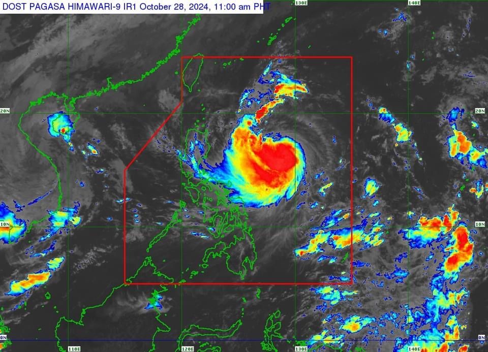
The Philippine Atmospheric, Geophysical and Astronomical Services Administration (PAGASA) on Monday, Oct. 28 warned that Severe Tropical Storm “Leon” (international name: Kong-rey) may impact the northern portion of Luzon in the days leading up to All Saints’ and All Souls’ Days.
In a press conference, PAGASA Administrator Nathaniel Servando advised travelers to prepare and exercise caution, as the storm is expected to impact parts of Luzon in the coming days.
He noted that, unlike Severe Tropical Storm Kristine (Trami), Leon has a higher trajectory, but it will still bring heavy rains and strong winds to Northern Luzon.
PAGASA Assistant Weather Services Chief Chris Perez said Leon intensified from a tropical storm to severe tropical storm on Monday morning, with maximum sustained winds of 95 kilometers per hour (kph) near the center and gustiness reaching 115 kph.
Perez said Leon may reach typhoon status within the next 24 hours and there is a possibility it could become a super typhoon before its close approach or landfall over Batanes between Wednesday and Thursday, Oct. 30 and 31.
As of 10 a.m., the center of the severe tropical storm was located 735 kilometers east of Casiguran, Aurora, or 780 kilometers east of Echague, Isabela, moving westward at 20 kph.
In anticipation of Leon’s strong winds, PAGASA raised Signal No. 1 in Batanes, Cagayan (including Babuyan Islands), Isabela, Ilocos Norte, Abra, Apayao, Kalinga, eastern portion of Mountain Province (Natonin, Paracelis), eastern portion of Ifugao (Aguinaldo, Alfonso Lista), eastern portion of Quirino (Maddela), northern portion of Aurora (Dilasag, Casiguran, Dinalungan), and northern portion of Catanduanes (Pandan, Bagamanoc, Panganiban, Viga, Gigmoto).
The highest wind signal that may be hoisted during Leon’s occurrence is Signal No. 3 or 4, particularly in the extremeNorthern Luzon.
However, Perez said if Leon becomes a super typhoon, Signal No. 5 may be raised.
Heavy rainfall forecast
Perez said rains brought by Leon will likely begin on Tuesday afternoon, Oct. 29, and may continue until Friday or Saturday, Nov. 1 or 2.
Based on PAGASA’s heavy rainfall outlook, from Monday to Tuesday noon, the trough or extension of Leon may bring heavy to intense rainfall (100 to 200 millimeters) to Antique, while moderate to heavy rainfall (50 to 100 millimeters) may affect Cagayan, Occidental Mindoro, Negros Occidental, and Palawan.
From Tuesday noon to Wednesday noon, Oct. 30, intense to torrential rainfall (over 200 millimeters) may be experienced in Antique.
Heavy to intense rainfall is expected in Occidental Mindoro, Cagayan, Batanes, and Babuyan Islands, while moderate to heavy rainfall may prevail over Ilocos Norte, Ilocos Sur, Apayao, Negros Occidental, Aklan, Cavite, and Palawan.
From Wednesday noon to Thursday noon, Oct. 31, heavy to intense rains may be recorded in Batanes, Babuyan Islands, Occidental Mindoro, and Cavite, while moderate to heavy rainfall is expected in Ilocos Region, Antique, Palawan, Zambales, Bataan, and Batangas.
The rest of the country will be partly cloudy to cloudy with isolated rain showers due to localized thunderstorms.
In addition, Perez said PAGASA may issue gale warnings for the northern and eastern sections of Luzon as early as Monday afternoon. He advised travelers to expect disruptions in sea travel in these areas.
Meanwhile, no other weather systems are expected to affect the country, including the anticipated return of Severe Tropical Storm Kristine, which is no longer expected to re-enter the Philippine Area of Responsibility.