


Signal No. 1 may be raised due to tropical storm 'Leon'


The Philippine Atmospheric, Geophysical and Astronomical Services Administration (PAGASA) is likely to issue Wind Signal No. 1 over parts of Cagayan Valley and Bicol Region by Sunday evening, Oct. 27, following the entry of Tropical Storm “Leon” (international name: Kong-rey) into the Philippine Area of Responsibility (PAR) on Saturday evening, Oct. 26.
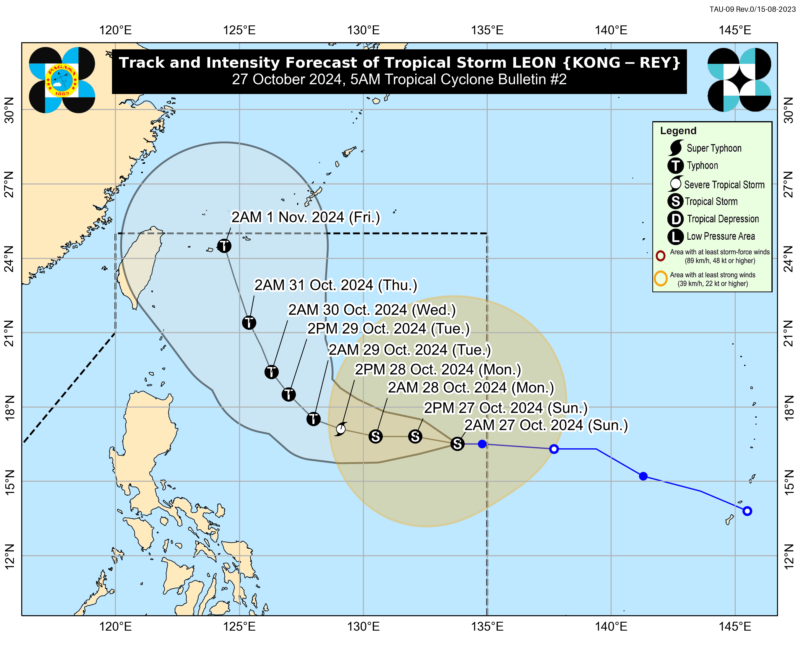
In its 5 a.m. bulletin on Sunday, PAGASA said the highest wind signal that may be raised as Leon approaches is Signal No. 2, depending on how much the storm’s forecast track shifts westward.
While it is unlikely to directly impact the country’s weather in the next few days, Leon’s outer rainbands may affect extreme Northern Luzon, depending on its proximity during its "recurvature" over the Philippine Sea.
The storm may also enhance the southwesterly wind flow, initially triggered by Severe Tropical Storm “Trami” (formerly Kristine), which could affect the western sections of Southern Luzon, Visayas, and Mindanao.
Cloudy skies with scattered rains and thunderstorms are expected in Western Visayas, Negros Island Region, Zamboanga Peninsula, Bangsamoro Autonomous Region in Muslim Mindanao, Occidental Mindoro, and Palawan due to the southwesterly wind flow.
Meanwhile, Metro Manila and the rest of the country will experience partly cloudy to cloudy conditions with isolated rain showers from localized thunderstorms.
PAGASA warned of possible flash floods and landslides throughout the archipelago.
Forecast track, intensity
As of 5 a.m., PAGASA said the center of Leon was located 1,195 kilometers east of Central Luzon, with maximum sustained winds of 65 kilometers per hour (kph) near the center and gustiness reaching 80 kph. It was moving westward at 20 kph.
Leon is expected to continue moving westward until early Monday morning to early Tuesday morning, Oct. 28 to 29.
After that, it may turn northwestward to north northwestward and make landfall over the Ryukyu Islands in Okinawa, Japan, early Friday morning, Nov. 1.
Although Leon is seen to remain far from the Philippine landmass, PAGASA has not ruled out a potential shift in the storm’s track further westward, particularly in the fourth and fifth days of the forecast.
The storm is expected to intensify over the next 24 hours gradually and may reach severe tropical storm strength by early Monday morning.
PAGASA said Leon could experience rapid intensification from Monday to Wednesday, potentially reaching typhoon strength by Monday evening or early Tuesday morning.