Why China is deploying its coast guard ships close to Zambales

Zambales is feared to become the newest flashpoint in the South China Sea as China Coast Guard (CCG) has consistently maintained its presence in the area in what the Philippine Coast Guard (PCG) sees as an attempt to “alter the status quo”.
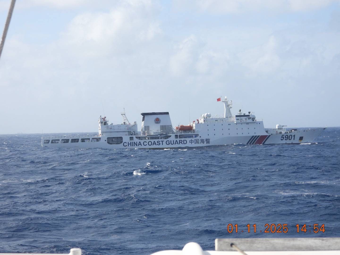
The PCG said CCG-5901, nicknamed “The Monster”, attempted to return to the coast of Zambales on Saturday, Jan. 11, but was blocked by multi-role response vessel BRP Teresa Magbanua (MRRV-9701), the flagship vessel of the PCG.
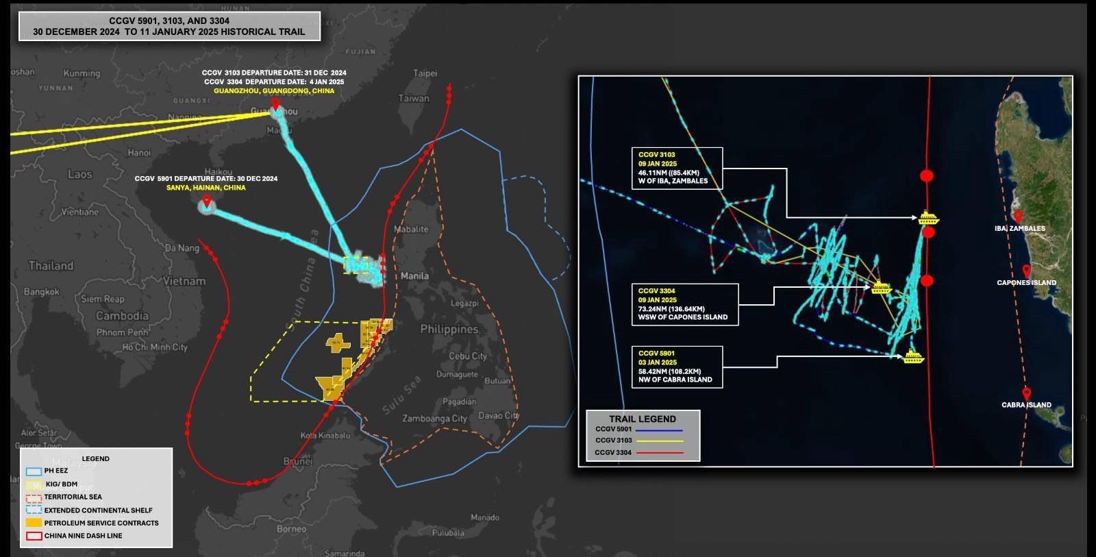
The cat-and-mouse situation at sea arose when BRP Teresa Magbanua “gradually pushed away” another Chinese ship, CCG-3304, which had been monitored around 70 to 80 nautical miles from the coast of Zambales since Jan. 9.
The monster ship, on the other hand, was first monitored in the area on Jan. 4, according to the PCG. It left on Jan. 8, but was replaced by other Chinese ships.
“The PCG vessel, BRP Teresa Magbanua, has proven to be a formidable asset in ensuring that the China Coast Guard vessel 3304 is gradually pushed away from the coastline of Zambales, achieving a remarkable distance of up to 97 nautical miles offshore,” said Commodore Jay Tarriela, PCG spokesperson for West Philippine Sea (WPS).
"This strategic maneuvering by the BRP Teresa Magbanua has prompted the People’s Republic of China to deploy the China Coast Guard 5901 'monster ship,'" he added.
Tarriela said that BRP Teresa Magbanua “boldly approached” the starboard (right) side of China’s monster ship at a close range, effectively hindering the latter’s attempts to move towards the Zambales coastline. In comparison, the 12,000-ton monster ship measures 165 meters long, almost double when compared to the 97-meter-long BRP Teresa Magbanua.
The monster ship was last located at 97 nautical miles off the coast of Zambales as of Saturday.

On Sunday, Jan. 12, the PCG said it analyzed a satellite imagery overlaid with the estimated grid coordinates of China’s so-called 10-dash line, which, Tarriela said, has been used as a justification by the PRC in maintaining the CCG vessels’ presence near Zambales.
The 10-dash line (formerly nine-dash line) is a set of imaginary lines shaped as letter “U” in the South China Sea. It is used by China to assert its claims over the majority of South China Sea, including parts located within the Philippines’ 200-nautical mile exclusive economic zone (EEZ), although an arbitral ruling has already invalidated Beijing’s claims in 2016.
Tarriela said that China is using the 10-dash line as the basis of the deployment of Chinese ships close to Zambales, as the fourth dash in the imaginary lines is approximately 60 to 80 nautical miles from the protruding landmass of Luzon and other nearby islands.
“Their goal is to normalize such deployments, and if these actions go unnoticed and unchallenged, it will enable them to alter the existing status quo,” Tarriela said.
The PCG commodore further explained that the “strategy of normalization” might soon be followed by the consistent presence of Chinese ships in Zambales to change the normal situation and operationalize their “illegal narrative”.
He said this has consistently been part of the “Chinese playbook”.
“This is why it is important for the Philippine Coast Guard to actively expose these unlawful deployments of Chinese vessels to the global community, ensuring that such actions are not normalized and that this bullying behavior does not succeed,” Tarriela said.