


 Philippines
National
Fujiwhara effect: PAGASA explains possibility of Kristine's return
Philippines
National
Fujiwhara effect: PAGASA explains possibility of Kristine's return
Fujiwhara effect: PAGASA explains possibility of Kristine's return


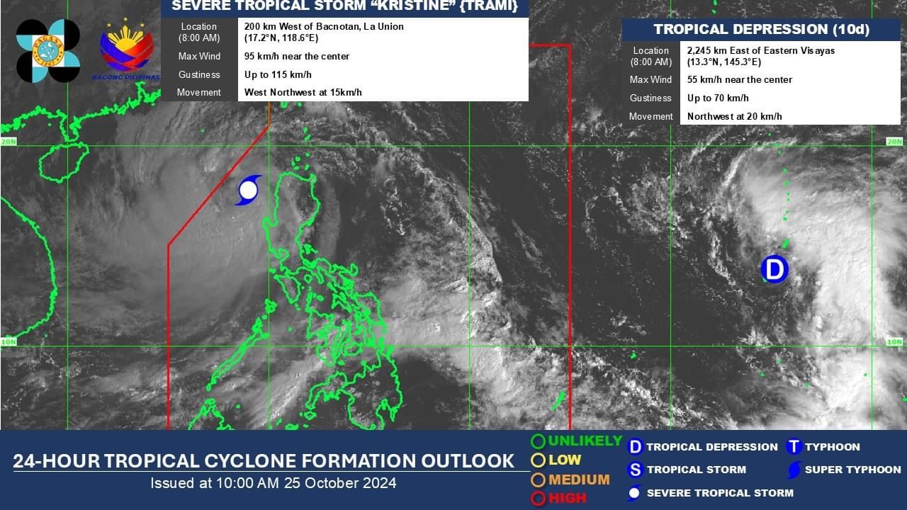
Severe Tropical Storm “Kristine” (international name “Trami”) may be on track to return to Luzon after exiting the Philippine Area of Responsibility (PAR) due to a potential interaction with an approaching tropical depression, which could trigger the Fujiwhara effect.
Philippine Atmospheric, Geophysical and Astronomical Services Administration (PAGASA) Weather Specialist Benison Estareja explained on Friday, Oct. 25 that the Fujiwhara effect occurs when two cyclones, each with at least tropical storm strength, come within approximately 1,400 kilometers of each other and begin to influence one another's movement and intensity.
As of 8 a.m. on Friday, the tropical depression was located 2,245 kilometers east of Eastern Visayas, with maximum sustained winds of 55 kilometers per hour (kph) and gusts reaching 70 kph. It is moving northwestward at a speed of 20 kph.
Meanwhile, the center of Kristine was located 200 kilometers west of Bacnotan, La Union, maintaining maximum sustained winds of 95 kph near the center and gusts of up to 115 kph. It is moving west-northwestward at 15 kph.
Estareja said the tropical depression is expected to gradually strengthen and enter the Philippine Area of Responsibility (PAR) on Sunday, Oct. 27, where it will be named “Leon.”
By then, it is projected to have developed into a tropical storm or a severe tropical storm, he added.
It is expected to move west-northwestward and reach the northern part of the Philippine Sea by early next week.
From Wednesday, Oct. 30, through the following weekend, it may slow down east of extreme Northern Luzon before “recurving” east of Taiwan.
At this stage, Estareja said the Fujiwhara effect may come into play, as the approach of potential tropical cyclone Leon could significantly impact the possible return or looping of Kristine, which was expected to have exited the PAR on Friday, Oct. 25.
Estareja said the looping of Kristine may lead to its reentry into the PAR and possible effects on the western coast of the country.
By the end of the first week of November, the tropical depression is expected to exit the PAR, while Kristine will likely weaken and finally move away from the Philippines, he added.
Estareja advised the public to continue monitoring PAGASA updates regarding the implications of Kristine’s possible return.